<< Our Photo Pages >> Corlick Hill Cairn - Cairn in Scotland in Inverclyde
Submitted by AstroGeologist on Monday, 27 May 2019 Page Views: 556
Neolithic and Bronze AgeSite Name: Corlick Hill Cairn Alternative Name: Corlick CairnCountry: Scotland County: Inverclyde Type: Cairn
Nearest Town: Greenock Nearest Village: Kilmacolm
Map Ref: NS2904872850
Latitude: 55.918268N Longitude: 4.73714W
Condition:
| 5 | Perfect |
| 4 | Almost Perfect |
| 3 | Reasonable but with some damage |
| 2 | Ruined but still recognisable as an ancient site |
| 1 | Pretty much destroyed, possibly visible as crop marks |
| 0 | No data. |
| -1 | Completely destroyed |
| 5 | Superb |
| 4 | Good |
| 3 | Ordinary |
| 2 | Not Good |
| 1 | Awful |
| 0 | No data. |
| 5 | Can be driven to, probably with disabled access |
| 4 | Short walk on a footpath |
| 3 | Requiring a bit more of a walk |
| 2 | A long walk |
| 1 | In the middle of nowhere, a nightmare to find |
| 0 | No data. |
| 5 | co-ordinates taken by GPS or official recorded co-ordinates |
| 4 | co-ordinates scaled from a detailed map |
| 3 | co-ordinates scaled from a bad map |
| 2 | co-ordinates of the nearest village |
| 1 | co-ordinates of the nearest town |
| 0 | no data |
Internal Links:
External Links:
")
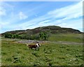
A stony, Grass covered Cairn on the North Greenock Moors.
First documented as a Cairn after the site received a visited by RCAHMS in 1954.
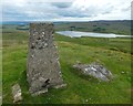
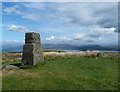
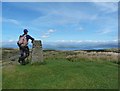
It measures about 12m in diameter, and over part of its surface natural rock protrudes through the turf. The presence of a few boulders set along the perimeter give the appearance of a denuded Cairn. There is a modern concrete post now set on the middle of the Cairn.
Located on the summit of Corlick Hill (The highest peak on the Moors North of Loch Thom & Gryffe Reservoir) the Cairn sits about 303m above sea level. Surrounded by rough uneven Moors now used for grazing Sheep, the hill is covered in rocky outcrops and boulders. Looking across the Clyde to the NW you can see the Holy Loch in Cowal, and parts of Loch Long and the Gare Loch on either side of the Rosneath Peninsula.
You have fantastic views of Arrochar Alps to the West and North, with the top of Ben Lomond visible 31km away. Upriver to the East you have great views of Carman Hill and Dumbarton Rock. Over 40km away to the SW, the tops of the Arran Mountains are visible above the hills on the Greenock Moors.
The whole area surrounding Corlick Hill is littered with Hut Circle Remains, and two Hut Circles were discovered not too long ago, on the lowers slopes of Corlick Hill overlooking Gryffe reservoir #2 (With a Cup Mark not far from one of them)
For more information : Canmore ID 331456
You may be viewing yesterday's version of this page. To see the most up to date information please register for a free account.
")
")
")
Do not use the above information on other web sites or publications without permission of the contributor.
Nearby Images from Geograph Britain and Ireland:
©2017(licence)
©2017(licence)
©2017(licence)
©2017(licence)

©2023(licence)
The above images may not be of the site on this page, they are loaded from Geograph.
Please Submit an Image of this site or go out and take one for us!
Click here to see more info for this site
Nearby sites
Key: Red: member's photo, Blue: 3rd party photo, Yellow: other image, Green: no photo - please go there and take one, Grey: site destroyed
Download sites to:
KML (Google Earth)
GPX (GPS waypoints)
CSV (Garmin/Navman)
CSV (Excel)
To unlock full downloads you need to sign up as a Contributory Member. Otherwise downloads are limited to 50 sites.
Turn off the page maps and other distractions
Nearby sites listing. In the following links * = Image available
276m SW 215° Corlick Hill Cup Mark Rock Art (NS28887263)
1.3km W 262° Darndaff Moor Cairn(s)* Cairn (NS2770772714)
1.5km WNW 294° Whitelees Moor Cairn Cairn (NS2770573526)
1.5km WNW 296° Whitelees Moor 2 Rock Art (NS2769173585)
1.6km SSW 204° Gryffe Cup Marks Rock Art (NS2834271413)
1.6km SSW 211° Greenock Moors* Ancient Village or Settlement (NS2816071511)
1.8km SSW 213° Gryffe Cairn A Cairn (NS2802271427)
1.9km SW 228° Darneme 1 Rock Art (NS27597166)
1.9km SW 229° Darneme 2 Rock Art (NS2753471644)
1.9km SW 230° Darneme 3 Rock Art (NS27517166)
1.9km SW 218° Gryffe Cairn B Cairn (NS2780071359)
2.0km WSW 246° Gall Moss 1 Rock Art (NS2720072101)
2.0km W 259° Gall Moss 3 Rock Art (NS2703472547)
2.2km WNW 294° Whitelees Moor 1 Rock Art (NS2710573824)
2.3km WSW 254° Gall Moss 2 Rock Art (NS2680972308)
2.5km E 86° Harelaw Cairn Cairn (NS3155572939)
2.5km ESE 124° Devol 3 Rock Art (NS3110071370)
2.5km NW 323° Whinhill Cup Marks Rock Art (NS2759074923)
2.6km SSW 202° Brewfield Cairn Cairn (NS2799370496)
2.9km ESE 117° Devol 2 Rock Art (NS31547144)
3.0km WSW 245° Goat Craig 2 Rock Art (NS2630071701)
3.0km WSW 246° Goat Craig 1 Rock Art (NS2627271734)
3.0km WSW 241° Goat Craigs Cairn (Loch Thom) Cairn (NS2633371487)
3.1km S 176° Green Water Cup Mark Rock Art (NS2913469705)
3.2km WSW 246° Goat Craig 9 Rock Art (NS2606271679)
View more nearby sites and additional images


 We would like to know more about this location. Please feel free to add a brief description and any relevant information in your own language.
 Wir möchten mehr über diese Stätte erfahren. Bitte zögern Sie nicht, eine kurze Beschreibung und relevante Informationen in Deutsch hinzuzufügen.
 Nous aimerions en savoir encore un peu sur les lieux. S'il vous plaît n'hesitez pas à ajouter une courte description et tous les renseignements pertinents dans votre propre langue.
 Quisieramos informarnos un poco más de las lugares. No dude en añadir una breve descripción y otros datos relevantes en su propio idioma.