<< Our Photo Pages >> Lanteglos Stone - Early Christian Sculptured Stone in England in Cornwall
Submitted by Thorgrim on Thursday, 03 June 2004 Page Views: 4069
Early Medieval (Dark Age)Site Name: Lanteglos StoneCountry: England
NOTE: This site is 1.034 km away from the location you searched for.
County: Cornwall Type: Early Christian Sculptured Stone
Nearest Town: Camelford Nearest Village: Lanteglos
Map Ref: SX088823 Landranger Map Number: 200
Latitude: 50.609006N Longitude: 4.703656W
Condition:
| 5 | Perfect |
| 4 | Almost Perfect |
| 3 | Reasonable but with some damage |
| 2 | Ruined but still recognisable as an ancient site |
| 1 | Pretty much destroyed, possibly visible as crop marks |
| 0 | No data. |
| -1 | Completely destroyed |
| 5 | Superb |
| 4 | Good |
| 3 | Ordinary |
| 2 | Not Good |
| 1 | Awful |
| 0 | No data. |
| 5 | Can be driven to, probably with disabled access |
| 4 | Short walk on a footpath |
| 3 | Requiring a bit more of a walk |
| 2 | A long walk |
| 1 | In the middle of nowhere, a nightmare to find |
| 0 | No data. |
| 5 | co-ordinates taken by GPS or official recorded co-ordinates |
| 4 | co-ordinates scaled from a detailed map |
| 3 | co-ordinates scaled from a bad map |
| 2 | co-ordinates of the nearest village |
| 1 | co-ordinates of the nearest town |
| 0 | no data |
Internal Links:
External Links:
I have visited· I would like to visit
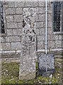
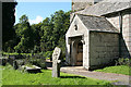
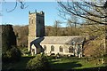
Theenchantednomads visited on 1st Jul 2023 - their rating: Cond: 3 Amb: 4 Access: 5 After a pilgrimage to St Juliots Well we walked by the stunning church of Lanteglos. Beautiful old crosses and this Longstone stood beside them.
lucasn visited - their rating: Cond: 5 Amb: 3 Access: 5
Average ratings for this site from all visit loggers: Condition: 4 Ambience: 3.5 Access: 5
")
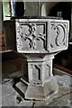
Rescued from a barn at Castle Goff farm, this stone is 10th century and very unusual in that the inscription is in Anglo-Saxon.
You may be viewing yesterday's version of this page. To see the most up to date information please register for a free account.
Do not use the above information on other web sites or publications without permission of the contributor.
Nearby Images from Geograph Britain and Ireland:
©2018(licence)
©2018(licence)
©2020(licence)
©2008(licence)
©2017(licence)
The above images may not be of the site on this page, they are loaded from Geograph.
Please Submit an Image of this site or go out and take one for us!
Click here to see more info for this site
Nearby sites
Key: Red: member's photo, Blue: 3rd party photo, Yellow: other image, Green: no photo - please go there and take one, Grey: site destroyed
Download sites to:
KML (Google Earth)
GPX (GPS waypoints)
CSV (Garmin/Navman)
CSV (Excel)
To unlock full downloads you need to sign up as a Contributory Member. Otherwise downloads are limited to 50 sites.
Turn off the page maps and other distractions
Nearby sites listing. In the following links * = Image available
141m NW 313° Lanteglos Crosses* Ancient Cross (SX087824)
573m WNW 299° Castle Goff* Ancient Village or Settlement (SX08318260)
780m NE 38° St Julitta's Well* Holy Well or Sacred Spring (SX093829)
988m NW 313° Delinuth Camp* Ancient Village or Settlement (SX081830)
1.7km NW 319° Delabole Quarry Stone Circle* Modern Stone Circle etc (SX0771783632)
1.8km NE 47° Camelford Cross* Ancient Cross (SX10128346)
2.0km ESE 120° Tresinney Cross* Ancient Cross (SX10518123)
2.5km N 0° Trethern Camp* Ancient Village or Settlement (SX089848)
2.6km E 96° Moorgate menhir* Standing Stone (Menhir) (SX11348196)
2.6km NE 48° Trefrew Road Spring/Well* Holy Well or Sacred Spring (SX1082083956)
2.8km NE 56° Tregoodwell Cross* Ancient Cross (SX11228380)
2.8km S 188° Helbury Castle* Hillfort (SX083795)
2.9km SW 233° St Teath Cross* Ancient Cross (SX0637980639)
3.1km E 93° Moorgate quartz cairns.* Barrow Cemetery (SX119820)
3.5km S 190° Michaelstow Cross* Ancient Cross (SX081789)
3.6km S 189° St Michael's Well (Michaelstow)* Holy Well or Sacred Spring (SX081788)
3.8km NNE 30° Slaughterbridge Enclosure Misc. Earthwork (SX108855)
3.9km NNE 30° King Arthur Stone* Early Christian Sculptured Stone (SX109856)
4.0km E 88° Roughtor Cairn Cairn (SX128823)
4.0km E 87° Advent Ring Cairn Ring Cairn (SX12858235)
4.0km ENE 78° Higher Parkwalls Tumulus Round Barrow(s) (SX128830)
4.3km ESE 119° Stannon stone setting* Standing Stones (SX12518007)
4.3km S 189° Trevenning Early Christian Sculptured Stone (SX07937806)
4.4km ESE 119° Stannon circle* Stone Circle (SX12578002)
4.4km SE 126° Dinnever Hill Cairn* Cairn (SX12297961)
View more nearby sites and additional images


 We would like to know more about this location. Please feel free to add a brief description and any relevant information in your own language.
 Wir möchten mehr über diese Stätte erfahren. Bitte zögern Sie nicht, eine kurze Beschreibung und relevante Informationen in Deutsch hinzuzufügen.
 Nous aimerions en savoir encore un peu sur les lieux. S'il vous plaît n'hesitez pas à ajouter une courte description et tous les renseignements pertinents dans votre propre langue.
 Quisieramos informarnos un poco más de las lugares. No dude en añadir una breve descripción y otros datos relevantes en su propio idioma.