<< Our Photo Pages >> Stonefield Park, Ayr - Standing Stone (Menhir) in Scotland in South Ayrshire
Submitted by markj99 on Saturday, 06 February 2021 Page Views: 1608
Neolithic and Bronze AgeSite Name: Stonefield Park, Ayr Alternative Name: Stonefield Park Road, DoonfootCountry: Scotland
NOTE: This site is 2.784 km away from the location you searched for.
County: South Ayrshire Type: Standing Stone (Menhir)
Nearest Town: Ayr
Map Ref: NS32271869
Latitude: 55.433295N Longitude: 4.652523W
Condition:
| 5 | Perfect |
| 4 | Almost Perfect |
| 3 | Reasonable but with some damage |
| 2 | Ruined but still recognisable as an ancient site |
| 1 | Pretty much destroyed, possibly visible as crop marks |
| 0 | No data. |
| -1 | Completely destroyed |
| 5 | Superb |
| 4 | Good |
| 3 | Ordinary |
| 2 | Not Good |
| 1 | Awful |
| 0 | No data. |
| 5 | Can be driven to, probably with disabled access |
| 4 | Short walk on a footpath |
| 3 | Requiring a bit more of a walk |
| 2 | A long walk |
| 1 | In the middle of nowhere, a nightmare to find |
| 0 | No data. |
| 5 | co-ordinates taken by GPS or official recorded co-ordinates |
| 4 | co-ordinates scaled from a detailed map |
| 3 | co-ordinates scaled from a bad map |
| 2 | co-ordinates of the nearest village |
| 1 | co-ordinates of the nearest town |
| 0 | no data |
Internal Links:
External Links:
")
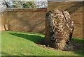
According to Canmore ID 41621 it once stood on Burton Farm land but it has now been subsumed by suburbia. The stone has not moved but its surroundings have changed from rural to urban. Its survival against the odds is something to be celebrated.
You may be viewing yesterday's version of this page. To see the most up to date information please register for a free account.
")
")
")
Do not use the above information on other web sites or publications without permission of the contributor.
Nearby Images from Geograph Britain and Ireland:
©2009(licence)

©2014(licence)
©2014(licence)
©2014(licence)
©2014(licence)
The above images may not be of the site on this page, they are loaded from Geograph.
Please Submit an Image of this site or go out and take one for us!
Click here to see more info for this site
Nearby sites
Key: Red: member's photo, Blue: 3rd party photo, Yellow: other image, Green: no photo - please go there and take one, Grey: site destroyed
Download sites to:
KML (Google Earth)
GPX (GPS waypoints)
CSV (Garmin/Navman)
CSV (Excel)
To unlock full downloads you need to sign up as a Contributory Member. Otherwise downloads are limited to 50 sites.
Turn off the page maps and other distractions
Nearby sites listing. In the following links * = Image available
2.3km SSE 154° Wallace's Stone (Blairstone Mains)* Early Christian Sculptured Stone (NS3321416579)
6.3km SE 133° Barbieston Farm cist* Cist (NS36751417)
6.6km NNE 19° Bruce's Well (Prestwick)* Holy Well or Sacred Spring (NS3467624801)
8.2km SSW 211° Howmoor* Stone Fort or Dun (NS2770711809)
8.4km S 187° Lyonston Stone* Standing Stone (Menhir) (NS30991039)
9.7km NNE 19° The Muckle Stane (Monkton)* Natural Stone / Erratic / Other Natural Feature (NS3578027790)
9.9km SW 219° Balchriston* Stone Fort or Dun (NS2572911176)
11.5km S 190° Kildoon Hillfort* Hillfort (NS29860738)
13.5km NE 50° Tarbolton Cist* Cist (NS4327)
14.3km NNE 13° Harpercroft Hillfort Hillfort (NS36003252)
14.5km ENE 56° Coilsfield (Tarbolton) Rock Art (NS44692624)
14.5km ENE 56° Tarbolton Tumulus Cairn (NS4469926247)
14.5km NNE 12° Wardlaw Hill Fort Hillfort (NS35923276)
15.3km N 10° Kemp Law* Stone Fort or Dun (NS35583364)
15.3km SW 220° Shanter Knowe* Artificial Mound (NS21890738)
15.6km SSW 192° Captain's Bridge (Drummochreen) W* Hillfort (NS28510356)
15.6km SSW 192° Captain's Bridge (Drummochreen) SE* Stone Fort or Dun (NS28530351)
15.9km SW 224° Bains Hill* Standing Stone (Menhir) (NS20750773)
15.9km SSW 201° East Threave* Cairn (NS25870411)
16.3km NNE 12° Dun Donald Hillfort (NS36363451)
17.1km NE 35° Witches Stane (Craigie) Natural Stone / Erratic / Other Natural Feature (NS42683231)
17.2km NNE 33° Craigie Hill Fort Hillfort (NS42243276)
17.4km NE 35° Craigie Dun Hillfort (NS42803254)
17.4km SSW 196° Cairn Hill (Dalquharran)* Cairn (NS26690219)
17.5km NE 35° Craigie Broch Broch or Nuraghe (NS42793272)
View more nearby sites and additional images


 We would like to know more about this location. Please feel free to add a brief description and any relevant information in your own language.
 Wir möchten mehr über diese Stätte erfahren. Bitte zögern Sie nicht, eine kurze Beschreibung und relevante Informationen in Deutsch hinzuzufügen.
 Nous aimerions en savoir encore un peu sur les lieux. S'il vous plaît n'hesitez pas à ajouter une courte description et tous les renseignements pertinents dans votre propre langue.
 Quisieramos informarnos un poco más de las lugares. No dude en añadir una breve descripción y otros datos relevantes en su propio idioma.