<< Our Photo Pages >> Balnacrae - Chambered Cairn in Scotland in Highlands
Submitted by vicky on Sunday, 22 December 2002 Page Views: 7637
Neolithic and Bronze AgeSite Name: BalnacraeCountry: Scotland
NOTE: This site is 7.572 km away from the location you searched for.
County: Highlands Type: Chambered Cairn
Nearest Town: Dingwall
Map Ref: NH533646 Landranger Map Number: 20
Latitude: 57.647353N Longitude: 4.459643W
Condition:
| 5 | Perfect |
| 4 | Almost Perfect |
| 3 | Reasonable but with some damage |
| 2 | Ruined but still recognisable as an ancient site |
| 1 | Pretty much destroyed, possibly visible as crop marks |
| 0 | No data. |
| -1 | Completely destroyed |
| 5 | Superb |
| 4 | Good |
| 3 | Ordinary |
| 2 | Not Good |
| 1 | Awful |
| 0 | No data. |
| 5 | Can be driven to, probably with disabled access |
| 4 | Short walk on a footpath |
| 3 | Requiring a bit more of a walk |
| 2 | A long walk |
| 1 | In the middle of nowhere, a nightmare to find |
| 0 | No data. |
| 5 | co-ordinates taken by GPS or official recorded co-ordinates |
| 4 | co-ordinates scaled from a detailed map |
| 3 | co-ordinates scaled from a bad map |
| 2 | co-ordinates of the nearest village |
| 1 | co-ordinates of the nearest town |
| 0 | no data |
Internal Links:
External Links:
I have visited· I would like to visit
Andy B has visited here
")
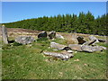
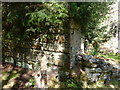
Balnacrae Chambered Cairn is a Neolithic burial monument, which was built 4000BC to 2000BC. It is 28.5m in diameter and its stones range from 2' 4" to 6' 6" in height.
You may be viewing yesterday's version of this page. To see the most up to date information please register for a free account.
")
")
Do not use the above information on other web sites or publications without permission of the contributor.
Nearby Images from Geograph Britain and Ireland:
©2011(licence)
©2011(licence)
©2011(licence)
©2021(licence)
©2011(licence)
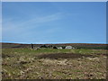
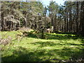
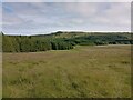
The above images may not be of the site on this page, they are loaded from Geograph.
Please Submit an Image of this site or go out and take one for us!
Click here to see more info for this site
Nearby sites
Key: Red: member's photo, Blue: 3rd party photo, Yellow: other image, Green: no photo - please go there and take one, Grey: site destroyed
Download sites to:
KML (Google Earth)
GPX (GPS waypoints)
CSV (Garmin/Navman)
CSV (Excel)
To unlock full downloads you need to sign up as a Contributory Member. Otherwise downloads are limited to 50 sites.
Turn off the page maps and other distractions
Nearby sites listing. In the following links * = Image available
3.6km SSW 209° Heights of Brae* Chambered Cairn (NH51446152)
4.1km SE 133° Clachan Biorach Chambered Cairn (NH562617)
4.2km SE 143° Cnoc Ravoch Chambered Cairn (NH557612)
4.7km ENE 68° Swordale Hill* Rock Art (NH5772066156)
4.8km ENE 69° Swordale Chambered Cairn Chambered Cairn (NH57886614)
5.9km SSE 162° Dingwall* Class I Pictish Symbol Stone (NH54935893)
5.9km ENE 69° Carn Liath (Upper Park) Chambered Cairn (NH589665)
6.2km SSW 211° Blairninich* Standing Stones (NH49935934)
6.7km SSW 203° Knock Farril* Vitrified Fort (NH505585)
7.8km SW 216° Strathpeffer* Class I Pictish Symbol Stone (NH48455852)
8.1km S 180° Ussie Chambered Cairn* Chambered Cairn (NH530565)
8.9km SSE 149° Mulchaich* Cairn (NH57665679)
9.2km SSW 207° Ballachnecore* Chambered Cairn (NH488565)
9.6km S 172° Conon Bridge* Henge (NH54295507)
9.8km SSW 195° Brahan Wood* Chambered Cairn (NH504552)
10.1km NNE 26° Balnagrotchen Chambered Cairn (NH581735)
10.4km NNE 25° Boath Long Cairn Chambered Cairn (NH581738)
10.6km NNE 26° Boath Short Chambered Cairn (NH58337395)
11.3km SW 217° Preas Mairi* Chambered Cairn (NH46095584)
11.4km E 99° St Martin's Well (Fortrose)* Holy Well or Sacred Spring (NH645625)
11.9km S 174° Bishop Kinkell Chambered Cairn (NH541527)
12.1km S 170° Muir of Allangrange* Chambered Cairn (NH55005259)
12.2km ESE 105° Woodhead Round Chambered Cairn* Chambered Cairn (NH650610)
12.3km S 172° Muir of Conan Chambered Cairn (NH546524)
12.4km SSE 165° Cairnside Chambered Tomb (NH560525)
View more nearby sites and additional images


 We would like to know more about this location. Please feel free to add a brief description and any relevant information in your own language.
 Wir möchten mehr über diese Stätte erfahren. Bitte zögern Sie nicht, eine kurze Beschreibung und relevante Informationen in Deutsch hinzuzufügen.
 Nous aimerions en savoir encore un peu sur les lieux. S'il vous plaît n'hesitez pas à ajouter une courte description et tous les renseignements pertinents dans votre propre langue.
 Quisieramos informarnos un poco más de las lugares. No dude en añadir una breve descripción y otros datos relevantes en su propio idioma.