<< Our Photo Pages >> Lewannick - Sculptured Stone in England in Cornwall
Submitted by thendlessbreeze on Sunday, 08 August 2004 Page Views: 6494
Multi-periodSite Name: LewannickCountry: England
NOTE: This site is 3.609 km away from the location you searched for.
County: Cornwall Type: Sculptured Stone
Nearest Village: Lewannick
Map Ref: SX275807
Latitude: 50.600462N Longitude: 4.438888W
Condition:
| 5 | Perfect |
| 4 | Almost Perfect |
| 3 | Reasonable but with some damage |
| 2 | Ruined but still recognisable as an ancient site |
| 1 | Pretty much destroyed, possibly visible as crop marks |
| 0 | No data. |
| -1 | Completely destroyed |
| 5 | Superb |
| 4 | Good |
| 3 | Ordinary |
| 2 | Not Good |
| 1 | Awful |
| 0 | No data. |
| 5 | Can be driven to, probably with disabled access |
| 4 | Short walk on a footpath |
| 3 | Requiring a bit more of a walk |
| 2 | A long walk |
| 1 | In the middle of nowhere, a nightmare to find |
| 0 | No data. |
| 5 | co-ordinates taken by GPS or official recorded co-ordinates |
| 4 | co-ordinates scaled from a detailed map |
| 3 | co-ordinates scaled from a bad map |
| 2 | co-ordinates of the nearest village |
| 1 | co-ordinates of the nearest town |
| 0 | no data |
Internal Links:
External Links:
I have visited· I would like to visit
lucasn visited - their rating: Cond: 2 Amb: 3 Access: 4
cazzyjane have visited here
")
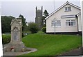
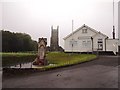
This stone is located in the church and has both ogham script and a latin translation on it.
It dates from 5-7 Century C.E and reads:
C IACIT VLCAGNI.
There is also another stone in the Churchyard.
You may be viewing yesterday's version of this page. To see the most up to date information please register for a free account.
")
")
")
Do not use the above information on other web sites or publications without permission of the contributor.
Nearby Images from Geograph Britain and Ireland:
©2007(licence)
©2016(licence)
©2015(licence)

©2013(licence)
©2018(licence)
The above images may not be of the site on this page, they are loaded from Geograph.
Please Submit an Image of this site or go out and take one for us!
Click here to see more info for this site
Nearby sites
Key: Red: member's photo, Blue: 3rd party photo, Yellow: other image, Green: no photo - please go there and take one, Grey: site destroyed
Download sites to:
KML (Google Earth)
GPX (GPS waypoints)
CSV (Garmin/Navman)
CSV (Excel)
To unlock full downloads you need to sign up as a Contributory Member. Otherwise downloads are limited to 50 sites.
Turn off the page maps and other distractions
Nearby sites listing. In the following links * = Image available
100m W 268° Blaunder's Well* Holy Well or Sacred Spring (SX274807)
1.6km N 350° Polyphant Cross* Ancient Cross (SX2727882324)
3.4km WSW 238° Upton Castle* Artificial Mound (SX2454178961)
4.2km SW 219° Bowda Stone Circle* Stone Circle (SX24757757)
4.2km SW 231° Clitters Cairn* Cairn (SX24157821)
4.2km SSW 203° Allabury Hillfort (SX257769)
4.3km SW 226° The Ridge Cairn* Cairn (SX24337785)
4.4km S 184° St Torney's Holy Well* Holy Well or Sacred Spring (SX27037631)
4.6km SW 235° Nine Stones (Altarnun)* Stone Circle (SX23617814)
4.9km WSW 249° Tregune Menhir* Standing Stone (Menhir) (SX2286379095)
4.9km SSW 204° Hawk's Tor (South)* Stone Row / Alignment (SX2532476301)
4.9km WSW 243° Fox Tor stone setting* Standing Stones (SX23027863)
5.1km W 277° St Nonna's Well* Holy Well or Sacred Spring (SX2243981533)
5.2km W 275° Altarnun Cross* Ancient Cross (SX223813)
5.3km W 279° Altarnun Cross B* Ancient Cross (SX22318170)
5.3km SW 230° Redmoor Marsh* Misc. Earthwork (SX23327742)
5.6km WNW 303° Jordan's Well* Holy Well or Sacred Spring (SX229839)
5.6km NW 304° Laneast* Ancient Cross (SX229840)
5.7km SSW 204° Twelve men's moor bronze age settlement* Ancient Village or Settlement (SX250756)
5.7km WSW 240° East Moor stone row* Stone Row / Alignment (SX22477803)
5.7km SSW 203° Twelve men's moor cairn and cist* Cist (SX25117551)
5.7km NNW 333° Bury Down Fort Hillfort (SX251859)
5.8km SSW 198° Twelve Men's Moor Cairns Barrow Cemetery (SX255753)
5.8km N 355° Egloskerry* Holy Well or Sacred Spring (SX272865)
5.9km SSW 201° Pyramid Stone (Kilmar Tor)* Natural Stone / Erratic / Other Natural Feature (SX25187526)
View more nearby sites and additional images


 We would like to know more about this location. Please feel free to add a brief description and any relevant information in your own language.
 Wir möchten mehr über diese Stätte erfahren. Bitte zögern Sie nicht, eine kurze Beschreibung und relevante Informationen in Deutsch hinzuzufügen.
 Nous aimerions en savoir encore un peu sur les lieux. S'il vous plaît n'hesitez pas à ajouter une courte description et tous les renseignements pertinents dans votre propre langue.
 Quisieramos informarnos un poco más de las lugares. No dude en añadir una breve descripción y otros datos relevantes en su propio idioma.