<< Our Photo Pages >> Mynydd Mwyn Mawr standing stones - Standing Stones in Wales in Anglesey
Submitted by AshArch on Tuesday, 16 May 2023 Page Views: 235
Neolithic and Bronze AgeSite Name: Mynydd Mwyn Mawr standing stonesCountry: Wales
NOTE: This site is 3.708 km away from the location you searched for.
County: Anglesey Type: Standing Stones
Nearest Town: Bangor Nearest Village: Llanerchymedd
Map Ref: SH41058256
Latitude: 53.316043N Longitude: 4.387534W
Condition:
| 5 | Perfect |
| 4 | Almost Perfect |
| 3 | Reasonable but with some damage |
| 2 | Ruined but still recognisable as an ancient site |
| 1 | Pretty much destroyed, possibly visible as crop marks |
| 0 | No data. |
| -1 | Completely destroyed |
| 5 | Superb |
| 4 | Good |
| 3 | Ordinary |
| 2 | Not Good |
| 1 | Awful |
| 0 | No data. |
| 5 | Can be driven to, probably with disabled access |
| 4 | Short walk on a footpath |
| 3 | Requiring a bit more of a walk |
| 2 | A long walk |
| 1 | In the middle of nowhere, a nightmare to find |
| 0 | No data. |
| 5 | co-ordinates taken by GPS or official recorded co-ordinates |
| 4 | co-ordinates scaled from a detailed map |
| 3 | co-ordinates scaled from a bad map |
| 2 | co-ordinates of the nearest village |
| 1 | co-ordinates of the nearest town |
| 0 | no data |
Internal Links:
External Links:
")
A pair of standing stones located atop a rock outcrop to the west of Llanerchymedd, enjoying panoramic views across most of the island's interior. The twin stones were initially investigated by Christopher Dickson and Nga Tram, with their findings published in Archaeology in Wales volume 53 (2014) - https://www.academia.edu/10910320/Discovery_of_Possible_New_Standing_Stone_Pair_Aligned_with_Hilltop_and_Spring_on_Anglesey.
Twin standing stones measuring no more than 1.3m in height each, and set 24m apart. The 'drill holes' visible on the stones could have been in an effort to demolish them, particularly as the southern stone appears to show evidence of it having been chipped away on several faces. It is unclear why the process was halted, but perhaps it is the hardness of the stone used - it's is of
hornblende picrite which is native to this part of Anglesey. Interestingly at least several prehistoric monuments within the immediate landscape have also used this stone in their construction.
You may be viewing yesterday's version of this page. To see the most up to date information please register for a free account.
")
Do not use the above information on other web sites or publications without permission of the contributor.
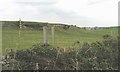
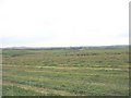
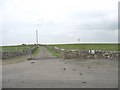
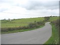
Nearby Images from Geograph Britain and Ireland:
©2008(licence)
©2008(licence)
©2008(licence)
©2008(licence)
©2008(licence)
The above images may not be of the site on this page, they are loaded from Geograph.
Please Submit an Image of this site or go out and take one for us!
Click here to see more info for this site
Nearby sites
Key: Red: member's photo, Blue: 3rd party photo, Yellow: other image, Green: no photo - please go there and take one, Grey: site destroyed
Download sites to:
KML (Google Earth)
GPX (GPS waypoints)
CSV (Garmin/Navman)
CSV (Excel)
To unlock full downloads you need to sign up as a Contributory Member. Otherwise downloads are limited to 50 sites.
Turn off the page maps and other distractions
Nearby sites listing. In the following links * = Image available
1.3km WNW 289° Carmel Standing Stone* Standing Stone (Menhir) (SH39798304)
2.5km NE 39° Bedd y Foel* Burial Chamber or Dolmen (SH42698444)
3.1km NE 52° Llwydiarth Esgob Stone* Rock Art (SH436844)
3.3km WSW 243° Maen Llechgynfarwy* Standing Stone (Menhir) (SH38108116)
3.9km NNE 33° Maen Chwyf* Natural Stone / Erratic / Other Natural Feature (SH43268574)
3.9km NNE 30° Bryn Dyfrydog* Standing Stone (Menhir) (SH431859)
3.9km ENE 62° Carreg Leidr* Standing Stone (Menhir) (SH446843)
4.1km ENE 65° Clorach Wells* Not Known (by us) (SH4487584177)
4.2km ENE 66° Ffynnon Gybi* Holy Well or Sacred Spring (SH44908414)
4.2km ENE 65° Ffynnon Deiniol* Holy Well or Sacred Spring (SH44908416)
4.2km E 81° Llech Golman* Standing Stone (Menhir) (SH452831)
4.9km WNW 282° New Church* Standing Stone (Menhir) (SH363837)
5.0km ENE 75° Llanfihangel Tre'r Beirdd Cross* Ancient Cross (SH4588783693)
5.1km ENE 79° Maen Addwyn* Standing Stone (Menhir) (SH461834)
5.3km NW 305° Bod Deiniol* Standing Stone (Menhir) (SH3683285739)
5.5km WNW 294° Bedd Branwen* Ring Cairn (SH3611184978)
5.6km NW 323° St Pabo's Church Memorial Stone* Early Christian Sculptured Stone (SH378871)
6.5km WSW 253° Presaddfed* Chambered Tomb (SH34768089)
7.0km W 273° Tre-Gwehelydd* Standing Stone (Menhir) (SH34068318)
7.1km NNW 346° Maen y Goges* Natural Stone / Erratic / Other Natural Feature (SH39518948)
7.2km ENE 64° Ponc y Garreg Hir* Standing Stone (Menhir) (SH47668549)
7.4km SSW 204° A55 Erratic* Natural Stone / Erratic / Other Natural Feature (SH3774475886)
7.5km S 174° Druid Farm* Standing Stones (SH416751)
7.5km WNW 289° Llynnon Mill and Iron Age Settlement* Museum (SH340852)
7.6km SE 140° Oriel Ynys Mon* Museum (SH458766)
View more nearby sites and additional images


 We would like to know more about this location. Please feel free to add a brief description and any relevant information in your own language.
 Wir möchten mehr über diese Stätte erfahren. Bitte zögern Sie nicht, eine kurze Beschreibung und relevante Informationen in Deutsch hinzuzufügen.
 Nous aimerions en savoir encore un peu sur les lieux. S'il vous plaît n'hesitez pas à ajouter une courte description et tous les renseignements pertinents dans votre propre langue.
 Quisieramos informarnos un poco más de las lugares. No dude en añadir una breve descripción y otros datos relevantes en su propio idioma.