<< Our Photo Pages >> Cairn Avel - Cairn in Scotland in Dumfries and Galloway
Submitted by vicky on Wednesday, 25 February 2004 Page Views: 7627
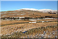
Neolithic and Bronze AgeSite Name: Cairn AvelCountry: Scotland County: Dumfries and Galloway Type: Cairn
Nearest Town: New Galloway Nearest Village: Carsphairn
Map Ref: NX55949245 Landranger Map Number: 77
Latitude: 55.205232N Longitude: 4.265294W
Condition:
| 5 | Perfect |
| 4 | Almost Perfect |
| 3 | Reasonable but with some damage |
| 2 | Ruined but still recognisable as an ancient site |
| 1 | Pretty much destroyed, possibly visible as crop marks |
| 0 | No data. |
| -1 | Completely destroyed |
| 5 | Superb |
| 4 | Good |
| 3 | Ordinary |
| 2 | Not Good |
| 1 | Awful |
| 0 | No data. |
| 5 | Can be driven to, probably with disabled access |
| 4 | Short walk on a footpath |
| 3 | Requiring a bit more of a walk |
| 2 | A long walk |
| 1 | In the middle of nowhere, a nightmare to find |
| 0 | No data. |
| 5 | co-ordinates taken by GPS or official recorded co-ordinates |
| 4 | co-ordinates scaled from a detailed map |
| 3 | co-ordinates scaled from a bad map |
| 2 | co-ordinates of the nearest village |
| 1 | co-ordinates of the nearest town |
| 0 | no data |
Internal Links:
External Links:
")
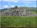
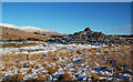
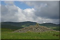
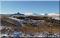
This long cairn "is about 118ft E by S to W by N. For about 50ft from the W end, the cairn has been so completely demolished that this area rises only 1ft above ground level, though the edge is obvious.
For more information see Canmore iD 63868, which continues: "Presumably this part of the cairn has been used for building the nearby walls, one of which runs along the N side of the cairn. The rest of the monument remains as a fine steep-sided cairn of bare stones 10ft high. The width at the E end is about 73ft but at the NE corner the cairn material extends about 10ft outside the steeply rising point of the cairn at a gentler pitch. As the ground dips into a hollow at this corner, this extension of the cairn may be a platform foundation for the main cairn, on the other hand it may be that the cairn has been much robbd round this corner, and the original width of the cairn was about 83 ft. The sides of the cairn taper westwards to about 30ft across at the W end. Three slabs, set on their edges and projecting 1ft high, may be parts of a peristalith. Two slabs are at the W end about 3 ft within the cairn edge, and the other is 5ft within the S edge 27ft to the E. These stones suggest a strictly trapezoidal plan with squared W end, though the cairn edge at the W end is now rounded in plan. The E end of the cairn is curiously irregular, being concave towards the SE corner, and it has not obviously been robbed."
You may be viewing yesterday's version of this page. To see the most up to date information please register for a free account.
Do not use the above information on other web sites or publications without permission of the contributor.
Nearby Images from Geograph Britain and Ireland:
©2006(licence)
©2019(licence)
©2008(licence)
©2019(licence)
©2019(licence)
The above images may not be of the site on this page, they are loaded from Geograph.
Please Submit an Image of this site or go out and take one for us!
Click here to see more info for this site
Nearby sites
Key: Red: member's photo, Blue: 3rd party photo, Yellow: other image, Green: no photo - please go there and take one, Grey: site destroyed
Download sites to:
KML (Google Earth)
GPX (GPS waypoints)
CSV (Garmin/Navman)
CSV (Excel)
To unlock full downloads you need to sign up as a Contributory Member. Otherwise downloads are limited to 50 sites.
Turn off the page maps and other distractions
Nearby sites listing. In the following links * = Image available
1.5km SE 142° Bardennoch* Cairn (NX56859120)
1.8km NNW 341° Holm of Daltallochan Standing Stone* Standing Stone (Menhir) (NX55399420)
1.9km NNW 338° Holm Of Daltallochan Stone Circle* Stone Circle (NX55289422)
2.0km SE 143° Braidenoch Cross Slabs* Early Christian Sculptured Stone (NX57099081)
2.1km N 353° Green Well of Scotland (Carsphairn)* Holy Well or Sacred Spring (NX5573494565)
4.9km S 175° Physic Well (Kells) Holy Well or Sacred Spring (NX5622587525)
5.6km WSW 256° King's Well (Carsphairn) Holy Well or Sacred Spring (NX5043591268)
5.6km WSW 256° King's Stone (Carsphairn) Natural Stone / Erratic / Other Natural Feature (NX50419127)
6.1km NNE 28° Gold Wells (Carsphairn) Holy Well or Sacred Spring (NX5896497793)
6.3km SSE 150° Stroangassel Stone Circle (NX589869)
7.4km NNW 333° Lamford Burn* Cairn (NX52829916)
7.5km E 93° Smittons Bridge* Cairn (NX63409188)
7.7km E 91° Stroanfreggan Craig* Hillfort (NX63709206)
8.1km E 95° Stroanfreggan Cairn* Cairn (NX64019142)
8.2km SE 131° Mackilston N* Cairn (NX61968682)
8.3km SE 131° Mackilston S* Cairn (NX61968678)
8.5km N 353° Brownhill Burn* Cairn (NS55210089)
8.6km E 81° Round Craigs* Cairn (NX64519355)
8.7km N 355° Water of Deugh* Chambered Cairn (NS55420114)
8.9km E 86° Chalybeate Well (Dalry)* Holy Well or Sacred Spring (NX6488792815)
9.8km NNW 327° Cairnennock Cairn (NS50800078)
10.1km E 86° Stellhead S* Cairn (NX66059285)
10.1km E 85° Stellhead N* Cairn (NX66089297)
11.4km NE 50° Mungo's Well (Carsphairn) Holy Well or Sacred Spring (NX6492799555)
13.4km SW 228° Devil's Bowling Green* Natural Stone / Erratic / Other Natural Feature (NX45658375)
View more nearby sites and additional images


 We would like to know more about this location. Please feel free to add a brief description and any relevant information in your own language.
 Wir möchten mehr über diese Stätte erfahren. Bitte zögern Sie nicht, eine kurze Beschreibung und relevante Informationen in Deutsch hinzuzufügen.
 Nous aimerions en savoir encore un peu sur les lieux. S'il vous plaît n'hesitez pas à ajouter une courte description et tous les renseignements pertinents dans votre propre langue.
 Quisieramos informarnos un poco más de las lugares. No dude en añadir una breve descripción y otros datos relevantes en su propio idioma.