

<< Text Pages >> Cwm Castell - Hillfort in Wales in Ceredigion
Submitted by Hayden on Friday, 22 April 2022 Page Views: 427
Iron Age and Later PrehistorySite Name: Cwm CastellCountry: Wales
NOTE: This site is 0.117 km away from the location you searched for.
County: Ceredigion Type: Hillfort
Nearest Town: Aberaeron Nearest Village: Mydroilyn
Map Ref: SN4694055440
Latitude: 52.175925N Longitude: 4.23983W
Condition:
| 5 | Perfect |
| 4 | Almost Perfect |
| 3 | Reasonable but with some damage |
| 2 | Ruined but still recognisable as an ancient site |
| 1 | Pretty much destroyed, possibly visible as crop marks |
| 0 | No data. |
| -1 | Completely destroyed |
| 5 | Superb |
| 4 | Good |
| 3 | Ordinary |
| 2 | Not Good |
| 1 | Awful |
| 0 | No data. |
| 5 | Can be driven to, probably with disabled access |
| 4 | Short walk on a footpath |
| 3 | Requiring a bit more of a walk |
| 2 | A long walk |
| 1 | In the middle of nowhere, a nightmare to find |
| 0 | No data. |
| 5 | co-ordinates taken by GPS or official recorded co-ordinates |
| 4 | co-ordinates scaled from a detailed map |
| 3 | co-ordinates scaled from a bad map |
| 2 | co-ordinates of the nearest village |
| 1 | co-ordinates of the nearest town |
| 0 | no data |
Internal Links:
External Links:
Hillfort in Ceredigion
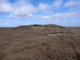
Cwm Castell (Valley Castle in English) is an irregular enclosure, about 110m north-west to south-east by 54m, crowning a knoll within the cwm of Afon Feinog, between the river and a relict channel; defined by scarps except on the south, where double ramparts flank a south-east facing entrance.
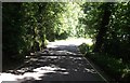
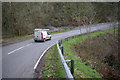
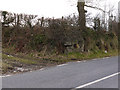
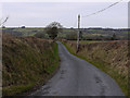
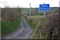
The B4342 road runs past the north-west face of the enclosure where a large lay-by is situated. The site can be accessed from here if you are willing to embark on a short but steep climb, however there is technically no public access as the land is private.
You may be viewing yesterday's version of this page. To see the most up to date information please register for a free account.
")
")
")
Do not use the above information on other web sites or publications without permission of the contributor.
Nearby Images from Geograph Britain and Ireland:
©2013(licence)
©2008(licence)
©2011(licence)
©2011(licence)
©2008(licence)
The above images may not be of the site on this page, they are loaded from Geograph.
Please Submit an Image of this site or go out and take one for us!
Click here to see more info for this site
Nearby sites
Key: Red: member's photo, Blue: 3rd party photo, Yellow: other image, Green: no photo - please go there and take one, Grey: site destroyed
Download sites to:
KML (Google Earth)
GPX (GPS waypoints)
CSV (Garmin/Navman)
CSV (Excel)
To unlock full downloads you need to sign up as a Contributory Member. Otherwise downloads are limited to 50 sites.
Turn off the page maps and other distractions
Nearby sites listing. In the following links * = Image available
3.6km WSW 246° Banc Rhosgoch Fach* Stone Row / Alignment (SN43625409)
3.8km SSE 154° Castell Moeddyn Ancient Village or Settlement (SN48495195)
4.0km S 170° Castell Moeddyn Fach Ancient Village or Settlement (SN47495143)
4.3km SSW 208° Whilgarn Cairn (SN44815172)
4.7km ENE 75° Pen-Y-Gaer (Ceredigion) Hillfort (SN51545648)
5.2km WNW 295° Cross of Gurhirt (Llanarth)* Early Christian Sculptured Stone (SN42295775)
6.1km WSW 246° Llwyn Crwn Barrow Round Barrow(s) (SN41275311)
6.5km WSW 245° Crug Cou Round Barrow(s) (SN40975284)
6.8km ENE 58° Castell Perthi-mawr* Hillfort (SN528589)
6.8km SE 130° Gaer Maesmynach* Hillfort (SN52005087)
7.0km WSW 240° Mynachlog-Uchaf Misc. Earthwork (SN40795215)
7.0km NNW 345° Pant-teg Enclosure* Hillfort (SN4533062300)
7.1km N 353° Tyn-y-coed the Second Well* Holy Well or Sacred Spring (SN4626462558)
7.1km N 353° Tyn-y-coed Well* Holy Well or Sacred Spring (SN4626062559)
7.2km N 349° Aberaeron Chalybeate Well* Holy Well or Sacred Spring (SN458626)
7.3km ESE 121° Gaer Fach (Cribyn) Ancient Village or Settlement (SN53135147)
7.4km NNE 18° Castell Dinerth* Promontory Fort / Cliff Castle (SN4949062370)
7.8km ESE 119° Cribyn Clota Hillfort (SN53625146)
8.0km N 3° St David's Church Hillfort* Hillfort (SN4761063370)
8.1km WSW 238° Blaengowonfawr Round Barrow(s) (SN39905142)
8.1km ENE 76° Castell Trefilan* Artificial Mound (SN5489557101)
8.5km E 89° Pen-Clawdd-Mawr Hillfort (SN55455535)
8.5km ENE 57° Trichrug cairns* Round Cairn (SN542599)
8.7km WSW 252° Ffynnon Dewi (Plwmp)* Holy Well or Sacred Spring (SN3854452988)
9.0km WSW 243° Crug Las Round Cairn (SN38805154)
View more nearby sites and additional images


 We would like to know more about this location. Please feel free to add a brief description and any relevant information in your own language.
 Wir möchten mehr über diese Stätte erfahren. Bitte zögern Sie nicht, eine kurze Beschreibung und relevante Informationen in Deutsch hinzuzufügen.
 Nous aimerions en savoir encore un peu sur les lieux. S'il vous plaît n'hesitez pas à ajouter une courte description et tous les renseignements pertinents dans votre propre langue.
 Quisieramos informarnos un poco más de las lugares. No dude en añadir una breve descripción y otros datos relevantes en su propio idioma.