
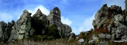

<< Our Photo Pages >> Llanelli Gorsedd Circle - 1962 - Modern Stone Circle etc in Wales in Carmarthenshire
Submitted by davidmorgan on Thursday, 12 February 2015 Page Views: 5102
Modern SitesSite Name: Llanelli Gorsedd Circle - 1962Country: Wales
NOTE: This site is 0.804 km away from the location you searched for.
County: Carmarthenshire Type: Modern Stone Circle etc
Nearest Town: Llanelli
Map Ref: SN5071301291
Latitude: 51.690467N Longitude: 4.161183W
Condition:
| 5 | Perfect |
| 4 | Almost Perfect |
| 3 | Reasonable but with some damage |
| 2 | Ruined but still recognisable as an ancient site |
| 1 | Pretty much destroyed, possibly visible as crop marks |
| 0 | No data. |
| -1 | Completely destroyed |
| 5 | Superb |
| 4 | Good |
| 3 | Ordinary |
| 2 | Not Good |
| 1 | Awful |
| 0 | No data. |
| 5 | Can be driven to, probably with disabled access |
| 4 | Short walk on a footpath |
| 3 | Requiring a bit more of a walk |
| 2 | A long walk |
| 1 | In the middle of nowhere, a nightmare to find |
| 0 | No data. |
| 5 | co-ordinates taken by GPS or official recorded co-ordinates |
| 4 | co-ordinates scaled from a detailed map |
| 3 | co-ordinates scaled from a bad map |
| 2 | co-ordinates of the nearest village |
| 1 | co-ordinates of the nearest town |
| 0 | no data |
Internal Links:
External Links:
")
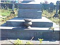
The stone circle erected for the 1962 Eisteddfod in the grounds of Parc Howard.
You may be viewing yesterday's version of this page. To see the most up to date information please register for a free account.
Do not use the above information on other web sites or publications without permission of the contributor.
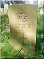
Nearby Images from Geograph Britain and Ireland:
©2007(licence)
©2019(licence)
©2009(licence)
©2009(licence)
©2009(licence)
The above images may not be of the site on this page, they are loaded from Geograph.
Please Submit an Image of this site or go out and take one for us!
Click here to see more info for this site
Nearby sites
Key: Red: member's photo, Blue: 3rd party photo, Yellow: other image, Green: no photo - please go there and take one, Grey: site destroyed
Download sites to:
KML (Google Earth)
GPX (GPS waypoints)
CSV (Garmin/Navman)
CSV (Excel)
To unlock full downloads you need to sign up as a Contributory Member. Otherwise downloads are limited to 50 sites.
Turn off the page maps and other distractions
Nearby sites listing. In the following links * = Image available
1.6km SW 233° Llanelli Gorsedd Circle - 2000* Modern Stone Circle etc (SN4937600347)
2.9km W 272° Cilymaenllwyd Stone Early Christian Sculptured Stone (SN47780148)
5.8km NNE 28° Ffynnon Diolch I Dduw* Holy Well or Sacred Spring (SN536063)
6.5km SSE 151° Pen-Y-Gaer (Llanrhidian Lower)* Hillfort (SS53659552)
7.3km NE 40° Brynmaen Standing Stone* Standing Stone (Menhir) (SN5552706764)
8.5km ESE 107° Gorseinon Gorsedd Circle* Modern Stone Circle etc (SS5882998591)
9.0km S 179° Cil ifor Top* Hillfort (SS506923)
9.1km S 184° Llanrhidian Lower Stone* Standing Stone (Menhir) (SS49769223)
9.1km S 184° Llanrhidian Upper Stone* Standing Stone (Menhir) (SS49769221)
9.2km SW 214° North Hill Tor Cave or Rock Shelter (SS453938)
9.5km S 191° Oldwalls (E) Standing Stone* Standing Stone (Menhir) (SS48689200)
9.6km SSW 192° Oldwalls (W) Standing Stone* Standing Stone (Menhir) (SS48429197)
9.6km SSW 197° Samson's Jack* Standing Stone (Menhir) (SS47669214)
9.9km S 176° Pen-y-Crug Barrow* Round Barrow(s) (SS51099137)
10.1km SSW 196° Ty'r-Coed* Standing Stone (Menhir) (SS47579168)
10.2km WNW 298° Ffynnon Mihangel Holy Well or Sacred Spring (SN41770628)
10.3km ESE 107° Carn Goch (West Glamorgan)* Cairn (SS605980)
10.4km SW 219° Advenctus Stone & Pillar Stones (Llanmadoc) Ancient Cross (SS4388993439)
10.6km SW 215° The Bulwark Hillfort (SS443928)
10.7km SSE 165° Tooth Cave* Cave or Rock Shelter (SS531909)
10.7km S 187° Cefn Bryn Cairn 1* Ring Cairn (SS4906690726)
10.7km NE 47° Bryn-Y-Rhyd* Standing Stone (Menhir) (SN5883008362)
10.9km S 187° Maen Ceti* Chambered Tomb (SS49149055)
10.9km S 187° Cefn Bryn Great Cairn* Round Cairn (SS49029056)
10.9km SW 216° Llanmadoc Hill Great Cairn* Cairn (SS43999271)
View more nearby sites and additional images


 We would like to know more about this location. Please feel free to add a brief description and any relevant information in your own language.
 Wir möchten mehr über diese Stätte erfahren. Bitte zögern Sie nicht, eine kurze Beschreibung und relevante Informationen in Deutsch hinzuzufügen.
 Nous aimerions en savoir encore un peu sur les lieux. S'il vous plaît n'hesitez pas à ajouter une courte description et tous les renseignements pertinents dans votre propre langue.
 Quisieramos informarnos un poco más de las lugares. No dude en añadir una breve descripción y otros datos relevantes en su propio idioma.