<< Text Pages >> Mount Batten - Ancient Mine, Quarry or other Industry in England in Devon
Submitted by Andy B on Monday, 27 May 2019 Page Views: 896
Multi-periodSite Name: Mount BattenCountry: England
NOTE: This site is 1.155 km away from the location you searched for.
County: Devon Type: Ancient Mine, Quarry or other Industry
Nearest Town: Plymouth
Map Ref: SX4876053196
Latitude: 50.359190N Longitude: 4.127577W
Condition:
| 5 | Perfect |
| 4 | Almost Perfect |
| 3 | Reasonable but with some damage |
| 2 | Ruined but still recognisable as an ancient site |
| 1 | Pretty much destroyed, possibly visible as crop marks |
| 0 | No data. |
| -1 | Completely destroyed |
| 5 | Superb |
| 4 | Good |
| 3 | Ordinary |
| 2 | Not Good |
| 1 | Awful |
| 0 | No data. |
| 5 | Can be driven to, probably with disabled access |
| 4 | Short walk on a footpath |
| 3 | Requiring a bit more of a walk |
| 2 | A long walk |
| 1 | In the middle of nowhere, a nightmare to find |
| 0 | No data. |
| 5 | co-ordinates taken by GPS or official recorded co-ordinates |
| 4 | co-ordinates scaled from a detailed map |
| 3 | co-ordinates scaled from a bad map |
| 2 | co-ordinates of the nearest village |
| 1 | co-ordinates of the nearest town |
| 0 | no data |
Internal Links:
External Links:
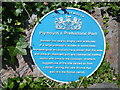
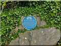
Site in Devon with evidence of Later Bronze Age to Iron Age trade.
An extensive midden deposit of later Bronze Age to Iron Age date, Roman occupation deposits, and burials of the 17th century, located close to the shore of Clovelly Bay on the eastern side of the limestone promontory of Mount Batten which projects into the upper eastern reaches of Plymouth Sound and the Cattewater. The Mount Batten headland has been identified by Professor Barry Cunliffe as a major port and commercial trading centre during the late prehistoric period which survived as a coastal port into Roman times.
Excavation has demonstrated that Mount Batten is one of only a small number of major prehistoric ports of trade known from Britain, the only comparable site known on the south coast being Hengistbury Head in Hampshire. The high quality of occupation evidence, including fine wares, and bronzes (some of which were produced locally but copying Mediterranean styles) suggests continental trade and influence during the Late Bronze Age. Later, in the Late Iron Age, the presence of Armorican and British coins suggests Iron Age contact between the local tribal group and the south English tribal groups of the Durotriges and the Dobunni and through them to the peoples of Armorica.
More at Historic England
You may be viewing yesterday's version of this page. To see the most up to date information please register for a free account.
Do not use the above information on other web sites or publications without permission of the contributor.
Nearby Images from Geograph Britain and Ireland:
©2023(licence)
©2023(licence)
©2015(licence)
©2015(licence)
©2009(licence)
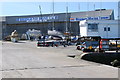
The above images may not be of the site on this page, they are loaded from Geograph.
Please Submit an Image of this site or go out and take one for us!
Click here to see more info for this site
Nearby sites
Key: Red: member's photo, Blue: 3rd party photo, Yellow: other image, Green: no photo - please go there and take one, Grey: site destroyed
Download sites to:
KML (Google Earth)
GPX (GPS waypoints)
CSV (Garmin/Navman)
CSV (Excel)
To unlock full downloads you need to sign up as a Contributory Member. Otherwise downloads are limited to 50 sites.
Turn off the page maps and other distractions
Nearby sites listing. In the following links * = Image available
558m NNE 24° Cattedown Bone Cave Cave or Rock Shelter (SX490537)
841m WNW 303° St Helena Volcanic Stone* Modern Stone Circle etc (SX48075368)
1.4km WNW 298° Plymouth Giants Hill Figure or Geoglyph (SX475539)
2.5km E 100° Burrow Hill Round Barrow(s) (SX512527)
3.8km W 259° Mount Edgecombe Barrow* Round Barrow(s) (SX4495052600)
3.9km E 79° Elburton Burial Mound Round Barrow(s) (SX526538)
4.2km WSW 253° St Julian's Well (Maker)* Holy Well or Sacred Spring (SX447521)
4.3km E 91° Elburton Cross* Ancient Cross (SX5304952984)
8.3km SW 235° Garry Wells* Holy Well or Sacred Spring (SX418487)
8.5km SW 233° Rame Head* Hillfort (SX41804825)
8.5km NE 40° Boringdon Camp* Hillfort (SX544596)
8.6km E 83° Wasteberry Camp Hillfort (SX5738854066)
9.6km WNW 299° Trehan Cross* Ancient Cross (SX405581)
11.0km N 9° Third Roborough Down Earthworks* Misc. Earthwork (SX5077364013)
11.0km N 9° Second Roborough Down Earthworks* Hillfort (SX50736407)
11.1km N 8° Roborough Down Earthworks* Hillfort (SX50556415)
11.2km NE 49° Crownhill Down Cairn Circle* Cairn (SX57486026)
11.3km NE 34° Shaugh Moor South Stone Circle (SX554623)
11.3km NE 37° Collard Tor circle Stone Circle (SX5584062030)
11.3km NE 37° Collard Tor W* Stone Row / Alignment (SX5583362045)
11.3km NE 37° Collard Tor E* Stone Row / Alignment (SX55856204)
11.4km NE 34° Hawk's Tor (Shaugh Moor) Cave or Rock Shelter (SX55396250)
11.4km W 277° Lady Well (Shevlock)* Holy Well or Sacred Spring (SX37425488)
11.5km NW 313° St Mary the Virgin (Cornwall)* Holy Well or Sacred Spring (SX4055461327)
11.7km NW 310° Holy Well near Saltash Holy Well or Sacred Spring (SX400610)
View more nearby sites and additional images


 We would like to know more about this location. Please feel free to add a brief description and any relevant information in your own language.
 Wir möchten mehr über diese Stätte erfahren. Bitte zögern Sie nicht, eine kurze Beschreibung und relevante Informationen in Deutsch hinzuzufügen.
 Nous aimerions en savoir encore un peu sur les lieux. S'il vous plaît n'hesitez pas à ajouter une courte description et tous les renseignements pertinents dans votre propre langue.
 Quisieramos informarnos un poco más de las lugares. No dude en añadir una breve descripción y otros datos relevantes en su propio idioma.