<< Our Photo Pages >> The Millenium Stone - Modern Stone Circle etc in Wales in Carmarthenshire
Submitted by PAB on Thursday, 16 August 2007 Page Views: 7876
Modern SitesSite Name: The Millenium Stone Alternative Name: National Botanic Garden of WalesCountry: Wales
NOTE: This site is 2.162 km away from the location you searched for.
County: Carmarthenshire Type: Modern Stone Circle etc
Nearest Town: Llanarthney Nearest Village: Ammanford
Map Ref: SN52201810
Latitude: 51.841886N Longitude: 4.146842W
Condition:
| 5 | Perfect |
| 4 | Almost Perfect |
| 3 | Reasonable but with some damage |
| 2 | Ruined but still recognisable as an ancient site |
| 1 | Pretty much destroyed, possibly visible as crop marks |
| 0 | No data. |
| -1 | Completely destroyed |
| 5 | Superb |
| 4 | Good |
| 3 | Ordinary |
| 2 | Not Good |
| 1 | Awful |
| 0 | No data. |
| 5 | Can be driven to, probably with disabled access |
| 4 | Short walk on a footpath |
| 3 | Requiring a bit more of a walk |
| 2 | A long walk |
| 1 | In the middle of nowhere, a nightmare to find |
| 0 | No data. |
| 5 | co-ordinates taken by GPS or official recorded co-ordinates |
| 4 | co-ordinates scaled from a detailed map |
| 3 | co-ordinates scaled from a bad map |
| 2 | co-ordinates of the nearest village |
| 1 | co-ordinates of the nearest town |
| 0 | no data |
Internal Links:
External Links:
I have visited· I would like to visit
PAB has visited here
")
The original scheme was scuppered when the stone sank off the Welsh coast just 17 miles into the 240-mile journey from the Preseli mountains in Pembrokeshire to Salisbury Plain in Wiltshire.
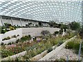
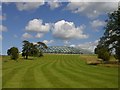
The eight-foot tall stone lay on the quayside in Milford Haven since being retrieved by Navy divers until it was moved to the National Botanic Gardens of Wales in Carmarthenshire on Thursday.
It now forms part of an exhibition at the gardens.
"The stone has been placed on its side on a plinth to show it was the one that made the journey," said Owen Jenkins, from the garden.
Source: BBC News.
Note: Remember this 'ill fated' modern stone?
You may be viewing yesterday's version of this page. To see the most up to date information please register for a free account.
")
")
Do not use the above information on other web sites or publications without permission of the contributor.
Nearby Images from Geograph Britain and Ireland:
©2005(licence)
©2008(licence)
©2008(licence)

©2010(licence)

©2010(licence)
The above images may not be of the site on this page, they are loaded from Geograph.
Please Submit an Image of this site or go out and take one for us!
Click here to see more info for this site
Nearby sites
Key: Red: member's photo, Blue: 3rd party photo, Yellow: other image, Green: no photo - please go there and take one, Grey: site destroyed
Download sites to:
KML (Google Earth)
GPX (GPS waypoints)
CSV (Garmin/Navman)
CSV (Excel)
To unlock full downloads you need to sign up as a Contributory Member. Otherwise downloads are limited to 50 sites.
Turn off the page maps and other distractions
Nearby sites listing. In the following links * = Image available
1.9km NNW 326° Ffinnant Fort Hillfort (SN512197)
3.5km SSE 166° Capel Erbach* Holy Well or Sacred Spring (SN52951472)
3.5km SSW 195° Capel Begewdin Holy Well or Sacred Spring (SN5115314712)
4.0km NW 315° Nantgaredig Standing Stones* Standing Stones (SN495210)
4.7km NE 43° Cae'r Garn Round Barrow* Round Barrow(s) (SN55522140)
5.4km E 80° Berrach Earthwork Misc. Earthwork (SN576189)
6.0km SW 215° Mynydd Llangynderyrn Burial Chambers* Burial Chamber or Dolmen (SN48541328)
6.2km SW 217° Mynydd Llanyynderyrn* Ring Cairn (SN48301325)
6.4km SW 221° Llangyndeyrn Standing Stone (Menhir) (SN479134)
6.6km SW 218° Castell Twby* Standing Stone (Menhir) (SN48021304)
6.8km WNW 295° Felin-Wen-Isaf* Round Barrow(s) (SN461212)
6.9km WNW 294° Carreg Annell* Standing Stone (Menhir) (SN4595421098)
7.2km WSW 243° Garreg Goch* Standing Stone (Menhir) (SN45651508)
7.3km WSW 243° Pystyll Gwyn* Standing Stone (Menhir) (SN4553615017)
7.5km WNW 295° Merlins Hill Hillfort* Hillfort (SN455215)
7.7km WNW 295° Merlin's Stone (Carmarthen)* Standing Stone (Menhir) (SN453215)
8.0km ESE 103° Ffynnon Gwenlais* Holy Well or Sacred Spring (SN600161)
8.5km NW 323° Parc-y-Gaer* Hillfort (SN47212500)
8.6km WNW 288° Carmarthen Museum* Museum (SN4408620973)
8.7km E 97° Pant-y-Llyn Boulder* Natural Stone / Erratic / Other Natural Feature (SN60821684)
8.9km ESE 111° Tireinion Enclosure Hillfort (SN60401464)
9.0km SE 137° Y Naw Carreg Stone Circle (SN58111130)
9.1km E 86° Pant-Y-Llyn Burnt Mounds Artificial Mound (SN613184)
9.2km SW 228° Maen Llwyd, Llangendeirne* Standing Stone (Menhir) (SN452121)
9.3km WSW 241° Maen Hir (Cloigyn)* Standing Stone (Menhir) (SN4393713807)
View more nearby sites and additional images


 We would like to know more about this location. Please feel free to add a brief description and any relevant information in your own language.
 Wir möchten mehr über diese Stätte erfahren. Bitte zögern Sie nicht, eine kurze Beschreibung und relevante Informationen in Deutsch hinzuzufügen.
 Nous aimerions en savoir encore un peu sur les lieux. S'il vous plaît n'hesitez pas à ajouter une courte description et tous les renseignements pertinents dans votre propre langue.
 Quisieramos informarnos un poco más de las lugares. No dude en añadir una breve descripción y otros datos relevantes en su propio idioma.