<< Our Photo Pages >> St Sulien's Church Carved Stone - Early Christian Sculptured Stone in Wales in Ceredigion
Submitted by coldrum on Monday, 11 October 2010 Page Views: 4315
Early Medieval (Dark Age)Site Name: St Sulien's Church Carved StoneCountry: Wales
NOTE: This site is 0.512 km away from the location you searched for.
County: Ceredigion Type: Early Christian Sculptured Stone
Map Ref: SN5714951242
Latitude: 52.140948N Longitude: 4.088873W
Condition:
| 5 | Perfect |
| 4 | Almost Perfect |
| 3 | Reasonable but with some damage |
| 2 | Ruined but still recognisable as an ancient site |
| 1 | Pretty much destroyed, possibly visible as crop marks |
| 0 | No data. |
| -1 | Completely destroyed |
| 5 | Superb |
| 4 | Good |
| 3 | Ordinary |
| 2 | Not Good |
| 1 | Awful |
| 0 | No data. |
| 5 | Can be driven to, probably with disabled access |
| 4 | Short walk on a footpath |
| 3 | Requiring a bit more of a walk |
| 2 | A long walk |
| 1 | In the middle of nowhere, a nightmare to find |
| 0 | No data. |
| 5 | co-ordinates taken by GPS or official recorded co-ordinates |
| 4 | co-ordinates scaled from a detailed map |
| 3 | co-ordinates scaled from a bad map |
| 2 | co-ordinates of the nearest village |
| 1 | co-ordinates of the nearest town |
| 0 | no data |
Internal Links:
External Links:
I have visited· I would like to visit
limestonepavement has visited here
")
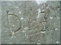
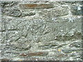
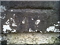
Roughly shaped rectangular pillar-stone, circa 1.0m long by 0.3m wide by 0.15m deep. The main faces bear vertical panels of carved ornament in low relief with eight-cord plain knotwork at the front and square fret-pattern, disposed diagonally, at the back. 8th - 9th century.
Source: Coflein
You may be viewing yesterday's version of this page. To see the most up to date information please register for a free account.
")
")
Do not use the above information on other web sites or publications without permission of the contributor.
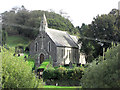
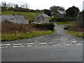
Nearby Images from Geograph Britain and Ireland:
©2011(licence)
©2015(licence)
©2015(licence)
©2015(licence)
©2015(licence)
The above images may not be of the site on this page, they are loaded from Geograph.
Please Submit an Image of this site or go out and take one for us!
Click here to see more info for this site
Nearby sites
Key: Red: member's photo, Blue: 3rd party photo, Yellow: other image, Green: no photo - please go there and take one, Grey: site destroyed
Download sites to:
KML (Google Earth)
GPX (GPS waypoints)
CSV (Garmin/Navman)
CSV (Excel)
To unlock full downloads you need to sign up as a Contributory Member. Otherwise downloads are limited to 50 sites.
Turn off the page maps and other distractions
Nearby sites listing. In the following links * = Image available
317m ENE 65° St Sulien's Church Enclosure Ancient Village or Settlement (SN57445137)
1.6km E 82° Coed-Parc Gaer Hillfort (SN58795143)
2.2km SSE 155° Castell Olwen* Hillfort (SN5801949254)
2.4km ESE 116° Castell Allt-Goch* Hillfort (SN59335012)
2.9km SSE 164° Lampeter Gorsedd Circle* Modern Stone Circle etc (SN57854841)
3.2km E 94° Castell Goetre* Hillfort (SN60325095)
3.5km W 272° Cribyn Clota Hillfort (SN53625146)
3.7km ENE 63° Ffynnon-Wen* Holy Well or Sacred Spring (SN60535283)
3.8km SE 137° Bryn Maen Caerau* Ancient Village or Settlement (SN59704836)
4.0km W 272° Gaer Fach (Cribyn) Ancient Village or Settlement (SN53135147)
4.4km NNW 336° Pen-Clawdd-Mawr Hillfort (SN55455535)
5.1km W 264° Gaer Maesmynach* Hillfort (SN52005087)
6.0km ESE 121° Caer Cadwgan Hillfort (SN62234796)
6.3km ESE 106° Tir Ifan (Cellan)* Misc. Earthwork (SN63134931)
6.3km NNW 337° Castell Trefilan* Artificial Mound (SN5489557101)
6.7km SE 126° Bryn Goleu* Cairn (SN62434712)
7.1km N 3° Pen-Y-Gaer (Nantcwnlle)* Hillfort (SN57735833)
7.1km SE 131° Hirfaen Gwyddog* Standing Stone (Menhir) (SN62454645)
7.7km NW 311° Pen-Y-Gaer (Ceredigion) Hillfort (SN51545648)
8.1km ESE 113° Carreg Y Bwci* Cairn (SN646479)
8.7km W 273° Castell Moeddyn Ancient Village or Settlement (SN48495195)
8.8km NNW 329° Castell Perthi-mawr* Hillfort (SN528589)
9.1km NNW 340° Trichrug cairns* Round Cairn (SN542599)
9.1km SSW 210° Pen-Y-Gaer (Llanybydder)* Hillfort (SN52394342)
9.2km ESE 102° Craig Twrch* Cairn (SN66104910)
View more nearby sites and additional images


 We would like to know more about this location. Please feel free to add a brief description and any relevant information in your own language.
 Wir möchten mehr über diese Stätte erfahren. Bitte zögern Sie nicht, eine kurze Beschreibung und relevante Informationen in Deutsch hinzuzufügen.
 Nous aimerions en savoir encore un peu sur les lieux. S'il vous plaît n'hesitez pas à ajouter une courte description et tous les renseignements pertinents dans votre propre langue.
 Quisieramos informarnos un poco más de las lugares. No dude en añadir una breve descripción y otros datos relevantes en su propio idioma.