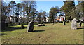
<< Our Photo Pages >> Gorseinon Gorsedd Circle - Modern Stone Circle etc in Wales in West Glamorgan
Submitted by Andy B on Monday, 15 December 2014 Page Views: 4487
Modern SitesSite Name: Gorseinon Gorsedd CircleCountry: Wales County: West Glamorgan Type: Modern Stone Circle etc
Nearest Town: Swansea Nearest Village: Gorseinon
Map Ref: SS5882998591
Latitude: 51.668308N Longitude: 4.042756W
Condition:
| 5 | Perfect |
| 4 | Almost Perfect |
| 3 | Reasonable but with some damage |
| 2 | Ruined but still recognisable as an ancient site |
| 1 | Pretty much destroyed, possibly visible as crop marks |
| 0 | No data. |
| -1 | Completely destroyed |
| 5 | Superb |
| 4 | Good |
| 3 | Ordinary |
| 2 | Not Good |
| 1 | Awful |
| 0 | No data. |
| 5 | Can be driven to, probably with disabled access |
| 4 | Short walk on a footpath |
| 3 | Requiring a bit more of a walk |
| 2 | A long walk |
| 1 | In the middle of nowhere, a nightmare to find |
| 0 | No data. |
| 5 | co-ordinates taken by GPS or official recorded co-ordinates |
| 4 | co-ordinates scaled from a detailed map |
| 3 | co-ordinates scaled from a bad map |
| 2 | co-ordinates of the nearest village |
| 1 | co-ordinates of the nearest town |
| 0 | no data |
Internal Links:
External Links:
I have visited· I would like to visit
geoffstickland has visited here
")
The National Eisteddfod of Wales can be traced back to 1176 when it is said that the first Eisteddfod was held, under the auspices of Lord Rhys, at his castle in Cardigan. There he held a grand gathering to which were invited poets and musicians from all over the country. A chair at the Lord's table was awarded to the best poet and musician, a tradition that prevails in the modern day National Eisteddfod.
Following 1176, many Eisteddfodau were held throughout Wales, under the patronage of Welsh gentry and noblemen. At the beginning of the nineteenth century, an Eisteddfod of historical significance was held at the Ivy Bush Inn in Carmarthen, when the Gorsedd of Bards first became officially associated with this national event. By this time, the Eisteddfod had developed in to a fully-fledged folk festival on a large scale. Text Source: /www.swansea.gov.uk
You may be viewing yesterday's version of this page. To see the most up to date information please register for a free account.
Do not use the above information on other web sites or publications without permission of the contributor.
davidmorgan has found this location on Google Street View:
Nearby Images from Geograph Britain and Ireland:
©2016(licence)

©2016(licence)
©2006(licence)
©2016(licence)
©2016(licence)
The above images may not be of the site on this page, they are loaded from Geograph.
Please Submit an Image of this site or go out and take one for us!
Click here to see more info for this site
Nearby sites
Key: Red: member's photo, Blue: 3rd party photo, Yellow: other image, Green: no photo - please go there and take one, Grey: site destroyed
Download sites to:
KML (Google Earth)
GPX (GPS waypoints)
CSV (Garmin/Navman)
CSV (Excel)
To unlock full downloads you need to sign up as a Contributory Member. Otherwise downloads are limited to 50 sites.
Turn off the page maps and other distractions
Nearby sites listing. In the following links * = Image available
1.8km ESE 108° Carn Goch (West Glamorgan)* Cairn (SS605980)
5.3km SE 134° Cockett Standing Stone Standing Stone (Menhir) (SS6253194791)
6.0km WSW 238° Pen-Y-Gaer (Llanrhidian Lower)* Hillfort (SS53659552)
7.1km E 93° Ffynnon Deml* Holy Well or Sacred Spring (SS65969798)
7.2km SE 144° Swansea Gorsedd Circle* Modern Stone Circle etc (SS6296392660)
7.7km NE 35° Mynydd Pysgodlyn Cairn Cairn (SN63400475)
7.8km NE 35° Penlle'r Bebyll* Ring Cairn (SN63510482)
7.9km NNE 13° Graig Fawr* Chambered Tomb (SN60840620)
7.9km S 191° Bishopston Burch Cairn (SS571909)
8.5km WNW 287° Llanelli Gorsedd Circle - 1962* Modern Stone Circle etc (SN5071301291)
8.8km NNW 336° Brynmaen Standing Stone* Standing Stone (Menhir) (SN5552706764)
8.9km NNE 25° Graig Fawr Ring Cairn* Ring Cairn (SN628066)
9.3km S 185° Kittle Hill Cave or Rock Shelter (SS577894)
9.3km NW 324° Ffynnon Diolch I Dduw* Holy Well or Sacred Spring (SN536063)
9.6km SW 215° Tooth Cave* Cave or Rock Shelter (SS531909)
9.6km W 279° Llanelli Gorsedd Circle - 2000* Modern Stone Circle etc (SN4937600347)
9.6km NNE 24° Graig Fawr Burnt Mound Misc. Earthwork (SN63000728)
9.7km NNE 24° Graig Fawr (East) Burnt Mound Misc. Earthwork (SN63080729)
9.8km N 358° Bryn-Y-Rhyd* Standing Stone (Menhir) (SN5883008362)
9.8km SSW 199° Trinity Well, Ilston* Holy Well or Sacred Spring (SS55308946)
9.9km SSW 209° Cat Hole Cave* Cave or Rock Shelter (SS53779002)
10.1km SSW 209° Parc le Breos* Chambered Tomb (SS53738984)
10.1km SSW 209° Church Hill Earthwork* Misc. Earthwork (SS53628987)
10.2km S 177° St Peters's Well* Holy Well or Sacred Spring (SS59048837)
10.3km SW 231° Cil ifor Top* Hillfort (SS506923)
View more nearby sites and additional images


 We would like to know more about this location. Please feel free to add a brief description and any relevant information in your own language.
 Wir möchten mehr über diese Stätte erfahren. Bitte zögern Sie nicht, eine kurze Beschreibung und relevante Informationen in Deutsch hinzuzufügen.
 Nous aimerions en savoir encore un peu sur les lieux. S'il vous plaît n'hesitez pas à ajouter une courte description et tous les renseignements pertinents dans votre propre langue.
 Quisieramos informarnos un poco más de las lugares. No dude en añadir una breve descripción y otros datos relevantes en su propio idioma.