<< Text Pages >> Matthew Davies - Marker Stone in Wales in Gwynedd
Submitted by Maffro on Saturday, 06 April 2024 Page Views: 67
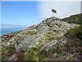
Modern SitesSite Name: Matthew DaviesCountry: Wales
NOTE: This site is 1.407 km away from the location you searched for.
County: Gwynedd Type: Marker Stone
Nearest Town: Barmouth
Map Ref: SH6134916917
Latitude: 52.732063N Longitude: 4.054821W
Condition:
| 5 | Perfect |
| 4 | Almost Perfect |
| 3 | Reasonable but with some damage |
| 2 | Ruined but still recognisable as an ancient site |
| 1 | Pretty much destroyed, possibly visible as crop marks |
| 0 | No data. |
| -1 | Completely destroyed |
| 5 | Superb |
| 4 | Good |
| 3 | Ordinary |
| 2 | Not Good |
| 1 | Awful |
| 0 | No data. |
| 5 | Can be driven to, probably with disabled access |
| 4 | Short walk on a footpath |
| 3 | Requiring a bit more of a walk |
| 2 | A long walk |
| 1 | In the middle of nowhere, a nightmare to find |
| 0 | No data. |
| 5 | co-ordinates taken by GPS or official recorded co-ordinates |
| 4 | co-ordinates scaled from a detailed map |
| 3 | co-ordinates scaled from a bad map |
| 2 | co-ordinates of the nearest village |
| 1 | co-ordinates of the nearest town |
| 0 | no data |
Internal Links:
External Links:
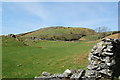
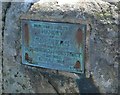
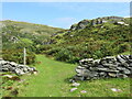
Marker Stone in Gwynedd
Maybe marker stone for the Cymer Abbey monks
You may be viewing yesterday's version of this page. To see the most up to date information please register for a free account.
Do not use the above information on other web sites or publications without permission of the contributor.
Nearby Images from Geograph Britain and Ireland:
©2010(licence)
©2018(licence)
©2023(licence)
©2023(licence)
©2023(licence)
The above images may not be of the site on this page, they are loaded from Geograph.
Please Submit an Image of this site or go out and take one for us!
Click here to see more info for this site
Nearby sites
Key: Red: member's photo, Blue: 3rd party photo, Yellow: other image, Green: no photo - please go there and take one, Grey: site destroyed
Download sites to:
KML (Google Earth)
GPX (GPS waypoints)
CSV (Garmin/Navman)
CSV (Excel)
To unlock full downloads you need to sign up as a Contributory Member. Otherwise downloads are limited to 50 sites.
Turn off the page maps and other distractions
Nearby sites listing. In the following links * = Image available
1.0km NNE 13° Ffridd Fechan Hill Fort* Hillfort (SH616179)
1.4km NNW 339° Cairn North of Hendre Coed Uchaf* Cairn (SH609182)
1.5km NNW 340° Settlement North of Hendre Coed Uchaf* Ancient Village or Settlement (SH609183)
1.5km NW 325° Bodfan Llanaber Standing Stone* Standing Stone (Menhir) (SH605182)
1.6km WNW 299° The Llanaber Stones* Early Christian Sculptured Stone (SH600177)
2.7km NE 41° Cerrig Arthur* Stone Circle (SH63161889)
2.8km NNE 19° Mynydd Egryn Cairn* Cairn (SH62331949)
3.3km NE 42° Cae-Tudur Ancient Village or Settlement (SH63601929)
3.4km N 3° Mynydd Egryn Settlement* Ancient Village or Settlement (SH61632030)
3.4km NNE 22° Bwlch y Rhiwgyr* Ring Cairn (SH62712004)
3.4km N 3° Hengwm Ring Cairn* Ring Cairn (SH61602032)
3.5km NNW 334° Egryn Abbey Settlement* Ancient Village or Settlement (SH599201)
3.6km N 358° Carneddau Hengwm* Chambered Cairn (SH61322055)
3.7km NNW 339° Settlement West of Mynydd Egryn* Ancient Village or Settlement (SH601204)
4.0km N 349° Pen-y-Dinas (Gwynedd)* Hillfort (SH607209)
4.0km NNW 342° Cae'r Llwyn Homestead* Ancient Village or Settlement (SH602208)
4.0km NE 45° Cerrig y Cledd (South)* Standing Stone (Menhir) (SH643197)
4.1km NNW 336° Hendre Eirian Hut Circles* Ancient Village or Settlement (SH598207)
4.2km NE 43° Cerrig y Cledd (North)* Natural Stone / Erratic / Other Natural Feature (SH643199)
4.4km N 2° Ffridd Newydd* Stone Circle (SH61642129)
4.4km NNW 327° Enclosed Hut Circle Settlement North of Tyddyn Mawr* Ancient Village or Settlement (SH590207)
4.7km SSE 154° Bron-Llety-Ifan* Rock Art (SH63331263)
4.7km ESE 116° Cefn Hir Uchaf Cairn* Cairn (SH6557014730)
4.8km N 356° Llecheiddior* Stone Circle (SH61112174)
4.9km SE 126° Standing Stone West of The Arthog Standing Stones* Standing Stone (Menhir) (SH65241396)
View more nearby sites and additional images


 We would like to know more about this location. Please feel free to add a brief description and any relevant information in your own language.
 Wir möchten mehr über diese Stätte erfahren. Bitte zögern Sie nicht, eine kurze Beschreibung und relevante Informationen in Deutsch hinzuzufügen.
 Nous aimerions en savoir encore un peu sur les lieux. S'il vous plaît n'hesitez pas à ajouter une courte description et tous les renseignements pertinents dans votre propre langue.
 Quisieramos informarnos un poco más de las lugares. No dude en añadir una breve descripción y otros datos relevantes en su propio idioma.