<< Our Photo Pages >> Copplestone Cross - Ancient Cross in England in Devon
Submitted by Thorgrim on Thursday, 07 October 2004 Page Views: 18302
Early Medieval (Dark Age)Site Name: Copplestone CrossCountry: England
NOTE: This site is 2.606 km away from the location you searched for.
County: Devon Type: Ancient Cross
Nearest Town: Crediton Nearest Village: Copplestone
Map Ref: SS7706802606 Landranger Map Number: 181
Latitude: 50.809923N Longitude: 3.746178W
Condition:
| 5 | Perfect |
| 4 | Almost Perfect |
| 3 | Reasonable but with some damage |
| 2 | Ruined but still recognisable as an ancient site |
| 1 | Pretty much destroyed, possibly visible as crop marks |
| 0 | No data. |
| -1 | Completely destroyed |
| 5 | Superb |
| 4 | Good |
| 3 | Ordinary |
| 2 | Not Good |
| 1 | Awful |
| 0 | No data. |
| 5 | Can be driven to, probably with disabled access |
| 4 | Short walk on a footpath |
| 3 | Requiring a bit more of a walk |
| 2 | A long walk |
| 1 | In the middle of nowhere, a nightmare to find |
| 0 | No data. |
| 5 | co-ordinates taken by GPS or official recorded co-ordinates |
| 4 | co-ordinates scaled from a detailed map |
| 3 | co-ordinates scaled from a bad map |
| 2 | co-ordinates of the nearest village |
| 1 | co-ordinates of the nearest town |
| 0 | no data |
Internal Links:
External Links:
I have visited· I would like to visit
kenhedges JohRvs would like to visit
SandyG AngieLake VIDoug have visited here
")
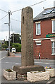
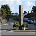
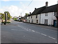
The quality of this cross is outstanding for south western England and it compares well with the crosses of northern England. The crosshead is missing and a medieval niche has been added at a later date to accommodate a saint's effigy. The cross was moved from its original site nearby in 1969 to facilitate road improvements.
You may be viewing yesterday's version of this page. To see the most up to date information please register for a free account.
")
")
")
")
Do not use the above information on other web sites or publications without permission of the contributor.
Nearby Images from Geograph Britain and Ireland:
©2019(licence)
©2015(licence)

©2011(licence)

©2015(licence)
©2015(licence)
The above images may not be of the site on this page, they are loaded from Geograph.
Please Submit an Image of this site or go out and take one for us!
Click here to see more info for this site
Nearby sites
Key: Red: member's photo, Blue: 3rd party photo, Yellow: other image, Green: no photo - please go there and take one, Grey: site destroyed
Download sites to:
KML (Google Earth)
GPX (GPS waypoints)
CSV (Garmin/Navman)
CSV (Excel)
To unlock full downloads you need to sign up as a Contributory Member. Otherwise downloads are limited to 50 sites.
Turn off the page maps and other distractions
Nearby sites listing. In the following links * = Image available
4.4km WSW 242° Puddock's Well* Holy Well or Sacred Spring (SS731006)
5.3km S 189° Lethen Castle Hillfort (SX761974)
6.4km W 260° Bow Henge* Henge (SS70750160)
6.7km WNW 286° Bow Timber Circle Timber Circle (SS707046)
6.7km SE 144° Posbury Camp Hillfort (SX80889711)
6.7km ESE 109° St Boniface's Well (Crediton)* Holy Well or Sacred Spring (SS834003)
6.7km SE 125° Uton Holy Well* Holy Well or Sacred Spring (SX825986)
6.8km ESE 108° Libbett's Well* Holy Well or Sacred Spring (SS835003)
7.4km NNE 24° Berry Castle (Black Dog)* Hillfort (SS802093)
7.4km SSE 157° Higher Bury Camp Hillfort (SX79789572)
8.6km W 260° North Tawton B Cursus Cursus (SS685013)
9.3km E 98° Shobrooke Church Preaching Cross Ancient Cross (SS863011)
9.3km E 97° Shobrooke Holy Well* Holy Well or Sacred Spring (SS8632301236)
10.4km NNW 343° Burridge Ancient Settlement* Ancient Village or Settlement (SS742126)
11.4km E 86° Raddon Hill* Causewayed Enclosure (SS885031)
12.2km W 264° North Tawton A Cursus Cursus (SS649017)
12.8km S 189° Prestonbury Castle* Hillfort (SX7477490045)
13.0km SW 228° Ringhole Copse Cross* Ancient Cross (SX6721794162)
13.3km S 181° Wooston Castle* Hillfort (SX76608935)
13.3km N 1° Long Stone (East Worlington)* Standing Stone (Menhir) (SS77511587)
13.3km SW 231° Ring Hill Cross* Ancient Cross (SX66559440)
13.5km S 191° Charles Cross* Ancient Cross (SX742894)
13.5km SW 231° Oxenham Cross* Ancient Cross (SX6625194414)
13.7km SSW 209° Spinsters' Rock* Burial Chamber or Dolmen (SX70109079)
13.8km SSW 210° Shilstone Common (DRE 1a) Cairn Circle Cairn (SX6990090800)
View more nearby sites and additional images


 We would like to know more about this location. Please feel free to add a brief description and any relevant information in your own language.
 Wir möchten mehr über diese Stätte erfahren. Bitte zögern Sie nicht, eine kurze Beschreibung und relevante Informationen in Deutsch hinzuzufügen.
 Nous aimerions en savoir encore un peu sur les lieux. S'il vous plaît n'hesitez pas à ajouter une courte description et tous les renseignements pertinents dans votre propre langue.
 Quisieramos informarnos un poco más de las lugares. No dude en añadir una breve descripción y otros datos relevantes en su propio idioma.