<< Our Photo Pages >> Sugar Loaf Hill Fort - Hillfort in Wales in Carmarthenshire
Submitted by geoffstickland on Monday, 29 June 2020 Page Views: 609
Iron Age and Later PrehistorySite Name: Sugar Loaf Hill FortCountry: Wales County: Carmarthenshire Type: Hillfort
Nearest Town: Llanwrtyd Wells
Map Ref: SN83484278
Latitude: 52.071091N Longitude: 3.70141W
Condition:
| 5 | Perfect |
| 4 | Almost Perfect |
| 3 | Reasonable but with some damage |
| 2 | Ruined but still recognisable as an ancient site |
| 1 | Pretty much destroyed, possibly visible as crop marks |
| 0 | No data. |
| -1 | Completely destroyed |
| 5 | Superb |
| 4 | Good |
| 3 | Ordinary |
| 2 | Not Good |
| 1 | Awful |
| 0 | No data. |
| 5 | Can be driven to, probably with disabled access |
| 4 | Short walk on a footpath |
| 3 | Requiring a bit more of a walk |
| 2 | A long walk |
| 1 | In the middle of nowhere, a nightmare to find |
| 0 | No data. |
| 5 | co-ordinates taken by GPS or official recorded co-ordinates |
| 4 | co-ordinates scaled from a detailed map |
| 3 | co-ordinates scaled from a bad map |
| 2 | co-ordinates of the nearest village |
| 1 | co-ordinates of the nearest town |
| 0 | no data |
Internal Links:
External Links:
I have visited· I would like to visit
geoffstickland has visited here
")
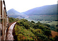
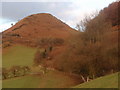
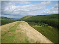
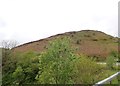
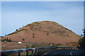
An Iron Age Hill Fort set high on the spine of the conspicuous Sugar Loaf Mountain right on the border of Powys and Carmarthenshire. The line of the ridge is roughly
NE to SW. The original shape of the fort is obscured by the passage of time and the abundant bracken. The defensive value of the Fort is enhanced by steep banks on either side and a steep access track on the East end.
You may be viewing yesterday's version of this page. To see the most up to date information please register for a free account.
")
Do not use the above information on other web sites or publications without permission of the contributor.
Nearby Images from Geograph Britain and Ireland:
©2011(licence)
©2011(licence)
©2009(licence)
©2019(licence)
©2011(licence)
The above images may not be of the site on this page, they are loaded from Geograph.
Please Submit an Image of this site or go out and take one for us!
Click here to see more info for this site
Nearby sites
Key: Red: member's photo, Blue: 3rd party photo, Yellow: other image, Green: no photo - please go there and take one, Grey: site destroyed
Download sites to:
KML (Google Earth)
GPX (GPS waypoints)
CSV (Garmin/Navman)
CSV (Excel)
To unlock full downloads you need to sign up as a Contributory Member. Otherwise downloads are limited to 50 sites.
Turn off the page maps and other distractions
Nearby sites listing. In the following links * = Image available
1.6km W 264° Maes Mynach Cairn Cemetery - Cwm Lwyndr Cairn Cairn (SN81844266)
1.9km SE 130° Abererbwll Roman Fortlet* Hillfort (SN84944152)
2.1km W 265° Maes Mynach Cairn Cemetery - Cwm Lwnor Cairn (SN81404266)
2.4km NE 55° Garth Fach Enclosure* Misc. Earthwork (SN8547044111)
2.8km NNW 328° Cynant Fach Cairn* Cairn (SN82054515)
3.4km NNE 20° Garn Wen (Llanwrtyd Wells)* Cairn (SN84754597)
3.6km WNW 286° Bryn Poeth Uchaf (North & South)* Ring Cairn (SN80054382)
3.6km WNW 290° Cerrig Cynant* Stone Circle (SN80114411)
3.7km ENE 62° Cae Rhedyn Enclosure* Ancient Village or Settlement (SN8681344441)
3.9km WSW 256° Cae Pentwyr* Cairn (SN79674196)
4.0km NNE 17° Waun Coli* Cairn (SN84754658)
4.1km W 272° Garn fawr (Carmarthenshire)* Cairn (SN79334304)
4.1km W 273° Garreg Garn Fair* Standing Stone (Menhir) (SN79334310)
4.2km NE 38° Pen Garn Goy possible Bronze Age Barrow* Cairn (SN86144607)
4.3km NE 38° Penmaenllwyd Cairn* Cairn (SN8617346091)
4.3km NW 313° Carreg Craig y Moch Standing Stone (Menhir) (SN804458)
4.4km N 351° Cnapau Hafodllewelyn Cairn* Cairn (SN82934711)
4.4km WNW 303° Carn Wen (Rhandirmwyn)* Cairn (SN79834527)
4.6km NE 35° Banc Glyn Gyrnant Enclosure* Hillfort (SN862465)
4.7km NW 317° Carn Twrch* Cairn (SN80344630)
4.8km NNE 23° Banc y Ddinas - possible Hill Fort/Defended Enclosure* Hillfort (SN85504715)
4.9km W 259° Pen Rhiw'r Onen Cairn* Cairn (SN78604197)
5.0km NW 317° Cerrig Cedny* Cairn (SN80144651)
5.3km SSW 213° Cefn Pâl North Defended Enclosure* Hillfort (SN80433840)
5.4km WSW 256° PEN-Y-RHIW FACH CAIRN Round Barrow(s) (SN78234165)
View more nearby sites and additional images


 We would like to know more about this location. Please feel free to add a brief description and any relevant information in your own language.
 Wir möchten mehr über diese Stätte erfahren. Bitte zögern Sie nicht, eine kurze Beschreibung und relevante Informationen in Deutsch hinzuzufügen.
 Nous aimerions en savoir encore un peu sur les lieux. S'il vous plaît n'hesitez pas à ajouter une courte description et tous les renseignements pertinents dans votre propre langue.
 Quisieramos informarnos un poco más de las lugares. No dude en añadir una breve descripción y otros datos relevantes en su propio idioma.