<< Our Photo Pages >> St Queran's Well - Holy Well or Sacred Spring in Scotland in Dumfries and Galloway
Submitted by vicky on Monday, 29 March 2004 Page Views: 9634
Springs and Holy WellsSite Name: St Queran's Well Alternative Name: St Querdon's Well; St Guerdon's Well; St Quergan's Well; St Jordan's Well; St Jargan's WellCountry: Scotland
NOTE: This site is 0.787 km away from the location you searched for.
County: Dumfries and Galloway Type: Holy Well or Sacred Spring
Nearest Town: Dumfries Nearest Village: Troqueer / Islesteps
Map Ref: NX95597222 Landranger Map Number: 84
Latitude: 55.033499N Longitude: 3.635132W
Condition:
| 5 | Perfect |
| 4 | Almost Perfect |
| 3 | Reasonable but with some damage |
| 2 | Ruined but still recognisable as an ancient site |
| 1 | Pretty much destroyed, possibly visible as crop marks |
| 0 | No data. |
| -1 | Completely destroyed |
| 5 | Superb |
| 4 | Good |
| 3 | Ordinary |
| 2 | Not Good |
| 1 | Awful |
| 0 | No data. |
| 5 | Can be driven to, probably with disabled access |
| 4 | Short walk on a footpath |
| 3 | Requiring a bit more of a walk |
| 2 | A long walk |
| 1 | In the middle of nowhere, a nightmare to find |
| 0 | No data. |
| 5 | co-ordinates taken by GPS or official recorded co-ordinates |
| 4 | co-ordinates scaled from a detailed map |
| 3 | co-ordinates scaled from a bad map |
| 2 | co-ordinates of the nearest village |
| 1 | co-ordinates of the nearest town |
| 0 | no data |
Be the first person to rate this site - see the 'Contribute!' box in the right hand menu.
Internal Links:
External Links:
I have visited· I would like to visit
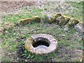
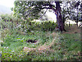
Greengirl visited on 12th Feb 2020 - their rating: Cond: 4 Amb: 5 Access: 4 St Queran's Well is easily accessible by a short footpath over flat (but muddy!) fields, signposted from the road. Two gates to go through and then enter a small wood to the left of the path at the end of which the well is visible. It is surrounded by a ring of stones. The trees around are decorated with "clooties" (rags) and other paraphernalia.On looking into the well, you will see a face on the metal grating.
")
Update June 2022: Classified as a holy well by Canmore - see their entry for Site ID 65680 (St Queran's Well), an entry from 1952 tells us: "This feature consists of a shallow, circular concrete pool, 3ft in diameter, fed by a spring and surrounded by a ring of stones 10ft in diameter".
E H M'Kerlie in 1916 observed: "Offerings at the well include ribbon or cloth on the bushes around the well and pins or coins in the water".
First appearing on the OS 6 inch map of 1854, "St Queran (or Querdon, Guerdon, Quergan or Jordan, etc) was a Scottish saint, the date assigned to him by Butler being the 9th September 876. The well was held in great repute for the cure of diseases, particularly of women and children, offerings being left at the well .... In the first half of the 17th century this well was referred to as St Jargan's".
The last site visit made by Canmore to this well was in July 1965. Google Earth images show a small group of trees at the grid reference given for the well, to the eastern side of Crooks Pow burn, and a circular feature some 200m to the SW of the given grid reference (which matches the photograph in the reference given below, and the photographs already submitted here).
There is mention of the well on the Scotland Start Here website, which has a photograph of the well, and adds: "The well dates back at least 500 years and a survey of the site in the 19th Century collected hundreds of coins which had been thrown into the well with some dating back as far as the 16th Century. The well has been held in high regard as a wishing place where diseases were cured especially for women and children. In the 17th Century it is recorded that the well was also known as St Jardan's Well which is simply another name given to the same Saint. Beside the well is a "cloutie tree". These trees exist around Scotland and many are beside these type of holy wells. A cloutie tree is where pieces of cloth and other goods are tied to the tree and given as offerings in return for wishes. You can still see many of the most recent offerings on the cloutie tree beside the well."
You may be viewing yesterday's version of this page. To see the most up to date information please register for a free account.
")
Do not use the above information on other web sites or publications without permission of the contributor.
Nearby Images from Geograph Britain and Ireland:
©2010(licence)
©2007(licence)

©2010(licence)
©2013(licence)
©2013(licence)
The above images may not be of the site on this page, they are loaded from Geograph.
Please Submit an Image of this site or go out and take one for us!
Click here to see more info for this site
Nearby sites
Key: Red: member's photo, Blue: 3rd party photo, Yellow: other image, Green: no photo - please go there and take one, Grey: site destroyed
Download sites to:
KML (Google Earth)
GPX (GPS waypoints)
CSV (Garmin/Navman)
CSV (Excel)
To unlock full downloads you need to sign up as a Contributory Member. Otherwise downloads are limited to 50 sites.
Turn off the page maps and other distractions
Nearby sites listing. In the following links * = Image available
228m WSW 245° Picts Knowe* Henge (NX95387213)
2.9km N 3° Troqueer Cursus Cursus (NX95837512)
3.0km N 9° Troqueer Cursus Cursus (NX96137517)
3.8km NNE 20° Dumfries Museum* Museum (NX9698975731)
3.9km NNE 24° St Allan's Wells (Dumfries) Holy Well or Sacred Spring (NX97307576)
4.0km WNW 293° Easthill* Stone Circle (NX91937388)
4.5km NNE 31° Greystone Park Stone Circle (NX980760)
5.8km W 276° Lochrutton Loch* Crannog (NX89837299)
5.9km NNW 330° Ladye Well (Terregles) Holy Well or Sacred Spring (NX92767744)
5.9km NW 314° Beacon Hill (Dumfries and Galloway)* Hillfort (NX91397643)
7.2km N 352° Twelve Apostles (Dumfries)* Stone Circle (NX9470079400)
7.3km SSE 168° Lochhill* Chambered Cairn (NX96886507)
7.3km N 354° Holywood A Cursus Cursus (NX94937951)
7.6km N 353° Holywood A Cursus Cursus (NX94857979)
7.7km N 354° Holywood B Cursus Cursus (NX949799)
8.0km SSE 159° Ingleston Cairn (NX983647)
8.0km N 355° Holywood B Cursus Cursus (NX951802)
8.1km S 169° Loch Kindar Crannog (NX96896423)
8.2km N 1° Holywood Cursus Cursus (NX95968038)
8.8km NNW 331° Holywood Cursus Cursus (NX91558004)
8.8km SE 128° Ward Law* Hillfort (NY0245766692)
8.8km NW 324° Hall Hill* Hillfort (NX90597949)
9.8km WNW 298° The Doons* Hillfort (NX86987699)
9.9km WNW 302° Angel Well (Barnsoul) Holy Well or Sacred Spring (NX87337770)
10.4km WSW 239° St Winning's Well (Kirkgunzeon)* Holy Well or Sacred Spring (NX86526699)
View more nearby sites and additional images


 We would like to know more about this location. Please feel free to add a brief description and any relevant information in your own language.
 Wir möchten mehr über diese Stätte erfahren. Bitte zögern Sie nicht, eine kurze Beschreibung und relevante Informationen in Deutsch hinzuzufügen.
 Nous aimerions en savoir encore un peu sur les lieux. S'il vous plaît n'hesitez pas à ajouter une courte description et tous les renseignements pertinents dans votre propre langue.
 Quisieramos informarnos un poco más de las lugares. No dude en añadir una breve descripción y otros datos relevantes en su propio idioma.