

<< Text Pages >> Cromwell's Stone (West Calder) - Natural Stone / Erratic / Other Natural Feature in Scotland in West Lothian
Submitted by Anne T on Monday, 22 October 2018 Page Views: 1951
Natural PlacesSite Name: Cromwell's Stone (West Calder)Country: Scotland
NOTE: This site is 3.624 km away from the location you searched for.
County: West Lothian Type: Natural Stone / Erratic / Other Natural Feature
Nearest Town: Livingstone Nearest Village: West Calder
Map Ref: NT03986068
Latitude: 55.829770N Longitude: 3.534438W
Condition:
| 5 | Perfect |
| 4 | Almost Perfect |
| 3 | Reasonable but with some damage |
| 2 | Ruined but still recognisable as an ancient site |
| 1 | Pretty much destroyed, possibly visible as crop marks |
| 0 | No data. |
| -1 | Completely destroyed |
| 5 | Superb |
| 4 | Good |
| 3 | Ordinary |
| 2 | Not Good |
| 1 | Awful |
| 0 | No data. |
| 5 | Can be driven to, probably with disabled access |
| 4 | Short walk on a footpath |
| 3 | Requiring a bit more of a walk |
| 2 | A long walk |
| 1 | In the middle of nowhere, a nightmare to find |
| 0 | No data. |
| 5 | co-ordinates taken by GPS or official recorded co-ordinates |
| 4 | co-ordinates scaled from a detailed map |
| 3 | co-ordinates scaled from a bad map |
| 2 | co-ordinates of the nearest village |
| 1 | co-ordinates of the nearest town |
| 0 | no data |
Be the first person to rate this site - see the 'Contribute!' box in the right hand menu.
Internal Links:
External Links:
Natural Stone / Erratic / Other Natural Feature in West Lothian
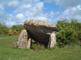
This large rounded stone is recorded as Canmore ID 49117. It is described as: "a large round stone from which Cromwell is traditionally said to have reconnoitred the surrounding country. Cromwell's Stone is an uninscribed natural boulder, embedded in the ground some 20.0m SW of the crest of an adjacent knoll. It measures 1.0m x 0.8m x 0.6m." (Source: OS Name Book 1852).
This stone is also featured on the Ancient Stones: A Guide to Standing Stones and Stone Circles in the South of Scotland - see their entry for Cromwell's Stone, Harburnhead, West Calder, which includes a description, directions for finding the stone with nearby parking, folklore and fieldnotes. The Ancient Stones adds that after two trips to find the stone, they found it under a fallen conifer. "The stone is plain and would otherwise be forgotten. Only a possible? association to that chap Oliver Cromwell to give it a place on the map. All good fun, I suppose, and I have the scratches to prove it!"
Note: Have you visited this site? Do you have any photographs, information or comments to add?
You may be viewing yesterday's version of this page. To see the most up to date information please register for a free account.
Do not use the above information on other web sites or publications without permission of the contributor.
Nearby Images from Geograph Britain and Ireland:
©2019(licence)
©2019(licence)
©2021(licence)
©2005(licence)
©2015(licence)
The above images may not be of the site on this page, they are loaded from Geograph.
Please Submit an Image of this site or go out and take one for us!
Click here to see more info for this site
Nearby sites
Key: Red: member's photo, Blue: 3rd party photo, Yellow: other image, Green: no photo - please go there and take one, Grey: site destroyed
Download sites to:
KML (Google Earth)
GPX (GPS waypoints)
CSV (Garmin/Navman)
CSV (Excel)
To unlock full downloads you need to sign up as a Contributory Member. Otherwise downloads are limited to 50 sites.
Turn off the page maps and other distractions
Nearby sites listing. In the following links * = Image available
9.6km SSW 201° Wester Yard Houses Souterrain Souterrain (Fogou, Earth House) (NT004518)
9.7km NE 49° Kirknewton stone Sculptured Stone (NT11426693)
10.5km NNW 329° Galabraes* Standing Stone (Menhir) (NS9881869839)
10.7km NE 56° Kaimes Standing Stones (NT130665)
11.3km S 184° Burngrange Cairn (NT029494)
11.3km NE 56° Dalmahoy Hill Hillfort (NT135669)
11.7km NNW 334° Knock Stone Circle* Modern Stone Circle etc (NS99137133)
12.2km NNW 333° Cairnpapple Hill* Round Cairn (NS98727175)
12.6km NE 43° Witches' Stone (Ratho)* Rock Art (NT12736973)
12.6km NE 43° Tormain Hill* Rock Art (NT12906967)
12.7km SSE 158° Dunsyre cup and ring marked stone* Rock Art (NT084488)
12.7km NNW 334° Lower Craigmailing (Torphichen)* Ancient Cross (NS98627222)
13.0km NNW 337° Craigmailing Boundary Marker (Torphichen)* Marker Stone (NS99097270)
13.1km NW 319° North Couston Refuge Stone* Early Christian Sculptured Stone (NS95637078)
13.2km N 349° Beecraigs Round Cairn (NT01827372)
13.6km E 95° Monks Rig, Font Stone* Ancient Cross (NT17585919)
13.6km NE 54° Newhouse Standing Stone Standing Stone (Menhir) (NT15296838)
13.7km NNW 333° Gormyre* Standing Stone (Menhir) (NS98067311)
13.8km NNW 328° Torphichen Churchyard Stone* Standing Stone (Menhir) (NS96847250)
13.8km NE 40° Witchis Stane* Standing Stone (Menhir) (NT13177104)
13.8km WNW 302° Boar Stone (Armadale)* Natural Stone / Erratic / Other Natural Feature (NS92336820)
14.1km NNW 338° Kipps Farm* Round Cairn (NS99087387)
14.5km NNE 34° Huly Hill Standing Stones* Standing Stones (NT1234272610)
14.5km NNE 34° Huly Hill Cairn* Round Cairn (NT1234272610)
14.6km NNW 339° Cockleroy Hill (Beecraigs)* Hillfort (NS98947438)
View more nearby sites and additional images


 We would like to know more about this location. Please feel free to add a brief description and any relevant information in your own language.
 Wir möchten mehr über diese Stätte erfahren. Bitte zögern Sie nicht, eine kurze Beschreibung und relevante Informationen in Deutsch hinzuzufügen.
 Nous aimerions en savoir encore un peu sur les lieux. S'il vous plaît n'hesitez pas à ajouter une courte description et tous les renseignements pertinents dans votre propre langue.
 Quisieramos informarnos un poco más de las lugares. No dude en añadir una breve descripción y otros datos relevantes en su propio idioma.