 with our Megalithic Portal iPhone app")


<< Our Photo Pages >> Tre Heslog Cist - Cist in Wales in Powys
Submitted by daijames on Tuesday, 23 September 2014 Page Views: 1734
Neolithic and Bronze AgeSite Name: Tre Heslog CistCountry: Wales County: Powys Type: Cist
Nearest Town: Rhayader
Map Ref: SN931689
Latitude: 52.307774N Longitude: 3.569363W
Condition:
| 5 | Perfect |
| 4 | Almost Perfect |
| 3 | Reasonable but with some damage |
| 2 | Ruined but still recognisable as an ancient site |
| 1 | Pretty much destroyed, possibly visible as crop marks |
| 0 | No data. |
| -1 | Completely destroyed |
| 5 | Superb |
| 4 | Good |
| 3 | Ordinary |
| 2 | Not Good |
| 1 | Awful |
| 0 | No data. |
| 5 | Can be driven to, probably with disabled access |
| 4 | Short walk on a footpath |
| 3 | Requiring a bit more of a walk |
| 2 | A long walk |
| 1 | In the middle of nowhere, a nightmare to find |
| 0 | No data. |
| 5 | co-ordinates taken by GPS or official recorded co-ordinates |
| 4 | co-ordinates scaled from a detailed map |
| 3 | co-ordinates scaled from a bad map |
| 2 | co-ordinates of the nearest village |
| 1 | co-ordinates of the nearest town |
| 0 | no data |
Internal Links:
External Links:
")
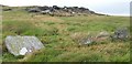
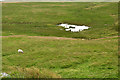
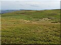
Measuring 1.2m long, 0.6m wide and 0.45m deep, 30 meters NE of Tres Heslog Stone Row
You may be viewing yesterday's version of this page. To see the most up to date information please register for a free account.
")
")
")
Do not use the above information on other web sites or publications without permission of the contributor.
Nearby Images from Geograph Britain and Ireland:
©2020(licence)

©2009(licence)
©2009(licence)
©2023(licence)
©2023(licence)
The above images may not be of the site on this page, they are loaded from Geograph.
Please Submit an Image of this site or go out and take one for us!
Click here to see more info for this site
Nearby sites
Key: Red: member's photo, Blue: 3rd party photo, Yellow: other image, Green: no photo - please go there and take one, Grey: site destroyed
Download sites to:
KML (Google Earth)
GPX (GPS waypoints)
CSV (Garmin/Navman)
CSV (Excel)
To unlock full downloads you need to sign up as a Contributory Member. Otherwise downloads are limited to 50 sites.
Turn off the page maps and other distractions
Nearby sites listing. In the following links * = Image available
23m NNE 14° Tre Heslog Stone Row* Stone Row / Alignment (SN9310668922)
562m ENE 69° Banc Trehesglog Cairn* Cist (SN93636909)
686m NNE 11° Briddell Felen B* Chambered Tomb (SN93256957)
749m N 8° Briddell Felen A* Standing Stone (Menhir) (SN93226964)
1.1km W 262° Crugyn Gwyddel Cairn* Cairn (SN91976877)
1.2km NNE 30° Clap yr Arian* Cairn (SN937699)
1.6km NE 54° Maen Serth* Standing Stone (Menhir) (SN944698)
1.8km NNW 342° Maengwyngweddew* Standing Stone (Menhir) (SN926706)
1.8km WSW 243° Esgair Pen-y-Garreg* Stone Row / Alignment (SN9145468091)
2.6km NW 318° Blaen Fign Cairn 2* Cairn (SN914709)
2.9km SSW 198° Y Glog Fawr Cairn* Cairn (SN92156618)
2.9km S 191° Glog Fawr Cairn* Cist (SN92486603)
3.1km SSW 195° Beddau Folau Chambered Cairn* Cairn (SN922659)
3.5km S 190° Carreg Bica Cairn* Round Cairn (SN924655)
3.9km NE 46° Marteg Valley* Cairn (SN95997155)
4.3km S 184° Elan Valley Visitor Centre* Modern Stone Circle etc (SN9272064599)
4.4km SSE 164° Carn Gafallt Cairn (SN94256469)
4.8km WSW 241° Cefn Troed Rhiw Drain Cist* Cist (SN88816667)
5.0km W 260° Esgair Gris Cairn* Cairn (SN88166817)
5.1km SW 222° Cefn Cwm-Coel Cist* Cist (SN89636519)
5.2km NNW 331° Cerrig Llwydion Round Barrow* Round Barrow(s) (SN90677345)
5.2km ENE 68° Creggin* Round Barrow(s) (SN980708)
5.4km E 94° Cefn Ceidio* Cairn (SN98496842)
5.5km W 268° Lluest Aber Caethon Ring Cairn* Ring Cairn (SN8759268841)
5.5km NNW 333° Rhiw Afon Cairn* Ring Cairn (SN90707387)
View more nearby sites and additional images


 We would like to know more about this location. Please feel free to add a brief description and any relevant information in your own language.
 Wir möchten mehr über diese Stätte erfahren. Bitte zögern Sie nicht, eine kurze Beschreibung und relevante Informationen in Deutsch hinzuzufügen.
 Nous aimerions en savoir encore un peu sur les lieux. S'il vous plaît n'hesitez pas à ajouter une courte description et tous les renseignements pertinents dans votre propre langue.
 Quisieramos informarnos un poco más de las lugares. No dude en añadir una breve descripción y otros datos relevantes en su propio idioma.