

<< Our Photo Pages >> Troed-Y-Rhiw Isaf, Cairn l and ll - Cairn in Wales in Powys
Submitted by vicky on Monday, 23 September 2002 Page Views: 4156
Neolithic and Bronze AgeSite Name: Troed-Y-Rhiw Isaf, Cairn l and llCountry: Wales County: Powys Type: Cairn
Nearest Town: Builth Wells Nearest Village: Llangammarch Wells
Map Ref: SN96124642 Landranger Map Number: 147
Latitude: 52.106322N Longitude: 3.51818W
Condition:
| 5 | Perfect |
| 4 | Almost Perfect |
| 3 | Reasonable but with some damage |
| 2 | Ruined but still recognisable as an ancient site |
| 1 | Pretty much destroyed, possibly visible as crop marks |
| 0 | No data. |
| -1 | Completely destroyed |
| 5 | Superb |
| 4 | Good |
| 3 | Ordinary |
| 2 | Not Good |
| 1 | Awful |
| 0 | No data. |
| 5 | Can be driven to, probably with disabled access |
| 4 | Short walk on a footpath |
| 3 | Requiring a bit more of a walk |
| 2 | A long walk |
| 1 | In the middle of nowhere, a nightmare to find |
| 0 | No data. |
| 5 | co-ordinates taken by GPS or official recorded co-ordinates |
| 4 | co-ordinates scaled from a detailed map |
| 3 | co-ordinates scaled from a bad map |
| 2 | co-ordinates of the nearest village |
| 1 | co-ordinates of the nearest town |
| 0 | no data |
Internal Links:
External Links:
I have visited· I would like to visit
geoffstickland has visited here
")
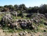
For more information see Coflein 305009 and Coflein 305010.
Cairn I is described as "a flat-topped, hill-top, cairn, measuring 26m in diameter and 1.8m high." and Cairn II as "a hill-top cairn, 16m in diameter and 1.1m high".
You may be viewing yesterday's version of this page. To see the most up to date information please register for a free account.
")
Do not use the above information on other web sites or publications without permission of the contributor.
Nearby Images from Geograph Britain and Ireland:
©2008(licence)
©2013(licence)
©2008(licence)
©2006(licence)
©2008(licence)
The above images may not be of the site on this page, they are loaded from Geograph.
Please Submit an Image of this site or go out and take one for us!
Click here to see more info for this site
Nearby sites
Key: Red: member's photo, Blue: 3rd party photo, Yellow: other image, Green: no photo - please go there and take one, Grey: site destroyed
Download sites to:
KML (Google Earth)
GPX (GPS waypoints)
CSV (Garmin/Navman)
CSV (Excel)
To unlock full downloads you need to sign up as a Contributory Member. Otherwise downloads are limited to 50 sites.
Turn off the page maps and other distractions
Nearby sites listing. In the following links * = Image available
1.9km N 350° Castell Du Hill Fort* Hillfort (SN95824826)
2.1km NW 306° Llangammarch Wells* Holy Well or Sacred Spring (SN944477)
2.5km WNW 302° Cae'r Dommon Mound - possible Barrow Cemetery (SN940478)
2.6km SW 231° Mabion's Way Monument* Modern Stone Circle etc (SN94024482)
2.7km WNW 288° Llangammarch Church Inscribed Stone* Early Christian Sculptured Stone (SN93524733)
3.9km WNW 299° Ffynnon Gadferth Medieval Holy Well* Holy Well or Sacred Spring (SN92734837)
4.0km SW 226° Tri Chrugiau* Round Barrow(s) (SN932437)
4.1km NNW 327° Ty'n y Llan Holy Well or Spring* Holy Well or Sacred Spring (SN93934990)
4.2km NW 311° Coed y Castell Hill Fort - possible* Hillfort (SN93004922)
4.3km NNW 327° Billy Wern Spring* Holy Well or Sacred Spring (SN938501)
4.9km SW 226° Fynnon Round Barrow* Round Barrow(s) (SN925431)
5.3km NW 314° Caerau Roman Auxiliary Fort* Hillfort (SN92395018)
6.1km NE 38° Prince Llywelyn (the great) memorial stone* Modern Stone Circle etc (SO000512)
6.2km WNW 285° Ty-Coch Cairn* Cairn (SN90184815)
6.3km SSW 204° Garn Wen (Trallong)* Round Cairn (SN93404076)
6.4km NE 37° Ffynnon Llewelyn* Holy Well or Sacred Spring (SO0009051407)
6.4km ESE 106° Cwm Owen stone III (possible)* Standing Stone (Menhir) (SO02254451)
6.5km NNE 33° Castle Hill Round Barrow 1 (Powys)* Round Barrow(s) (SN99785176)
6.6km WNW 295° Dol Y Garn Round Barrow* Round Barrow(s) (SN902493)
6.6km NNE 33° Castle Hill Round Barrow 2 (Powys)* Round Barrow(s) (SN99805188)
6.8km NNW 348° Glandulas Stone Circle* Modern Stone Circle etc (SN948531)
7.0km WSW 256° Pantioityn Standing Stone* Standing Stone (Menhir) (SN89274485)
7.3km WNW 299° Berth-lwyd pond* Misc. Earthwork (SN8975250083)
7.4km WSW 254° Parc Gwyn Standing Stone* Standing Stone (Menhir) (SN88954454)
7.5km S 169° Cefn Merthyr Cynog Mound* Cairn (SN97393902)
View more nearby sites and additional images


 We would like to know more about this location. Please feel free to add a brief description and any relevant information in your own language.
 Wir möchten mehr über diese Stätte erfahren. Bitte zögern Sie nicht, eine kurze Beschreibung und relevante Informationen in Deutsch hinzuzufügen.
 Nous aimerions en savoir encore un peu sur les lieux. S'il vous plaît n'hesitez pas à ajouter une courte description et tous les renseignements pertinents dans votre propre langue.
 Quisieramos informarnos un poco más de las lugares. No dude en añadir una breve descripción y otros datos relevantes en su propio idioma.