<< Our Photo Pages >> Ffynnon Cwm Ewyn - Holy Well or Sacred Spring in Wales in Powys
Submitted by KiwiBetsy on Tuesday, 23 November 2004 Page Views: 10749
Springs and Holy WellsSite Name: Ffynnon Cwm EwynCountry: Wales
NOTE: This site is 3.743 km away from the location you searched for.
County: Powys Type: Holy Well or Sacred Spring
Nearest Town: Llangynog Nearest Village: Pennant Melangell
Map Ref: SJ025273
Latitude: 52.834365N Longitude: 3.448739W
Condition:
| 5 | Perfect |
| 4 | Almost Perfect |
| 3 | Reasonable but with some damage |
| 2 | Ruined but still recognisable as an ancient site |
| 1 | Pretty much destroyed, possibly visible as crop marks |
| 0 | No data. |
| -1 | Completely destroyed |
| 5 | Superb |
| 4 | Good |
| 3 | Ordinary |
| 2 | Not Good |
| 1 | Awful |
| 0 | No data. |
| 5 | Can be driven to, probably with disabled access |
| 4 | Short walk on a footpath |
| 3 | Requiring a bit more of a walk |
| 2 | A long walk |
| 1 | In the middle of nowhere, a nightmare to find |
| 0 | No data. |
| 5 | co-ordinates taken by GPS or official recorded co-ordinates |
| 4 | co-ordinates scaled from a detailed map |
| 3 | co-ordinates scaled from a bad map |
| 2 | co-ordinates of the nearest village |
| 1 | co-ordinates of the nearest town |
| 0 | no data |
Internal Links:
External Links:
")
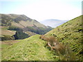
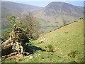
Ffynnon Cwm Ewyn lies on isolated Welsh moorland high above St Melangell’s Church at Pennant Melangell.
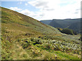
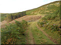
We spotted this well on a map in the excellent museum set up in the tower of this most delightful church and with directions from a local, crossed the stream and followed it down to a farmhouse to cut through their yard to gain access to a forestry track. A long, hard climb saw us first loose the trees on our right and, as promised, just before they also vanished on our left, there was the well, over a fence and almost obscured by a half fallen conifer.
The well, a rectangular, stone lined basin clad in moss and ferns still waited with crystal clear water for passers by just as it had since monks, pilgrims and farmers passed that way, maybe enroute to St Melangell’s below, further on to St Winifrede's at Holywell or simply to market.
In May 2003 we did our best to remove the conifer and let the sun reach in. We stood and thought of those visitors of long ago and hoped that the farmer wouldn’t object to present day ones.
The Clwyd-Powis Archaeologiocal Trust say that very little is known of the well but that it is “reputed to be a holy or medicinal well”.
You may be viewing yesterday's version of this page. To see the most up to date information please register for a free account.
Do not use the above information on other web sites or publications without permission of the contributor.
Nearby Images from Geograph Britain and Ireland:
©2009(licence)
©2011(licence)
©2019(licence)
©2011(licence)
©2009(licence)
The above images may not be of the site on this page, they are loaded from Geograph.
Please Submit an Image of this site or go out and take one for us!
Click here to see more info for this site
Nearby sites
Key: Red: member's photo, Blue: 3rd party photo, Yellow: other image, Green: no photo - please go there and take one, Grey: site destroyed
Download sites to:
KML (Google Earth)
GPX (GPS waypoints)
CSV (Garmin/Navman)
CSV (Excel)
To unlock full downloads you need to sign up as a Contributory Member. Otherwise downloads are limited to 50 sites.
Turn off the page maps and other distractions
Nearby sites listing. In the following links * = Image available
764m S 185° Pennant Melangell Cross Ancient Cross (SJ02422654)
808m ENE 69° Craig ty-glas* Cairn (SJ03262758)
3.2km E 94° Craig Rhiwarth* Hillfort (SJ057270)
3.4km ENE 77° Bedd Crynddyn* Cairn (SJ058280)
4.3km S 186° Afon y Dolau Gwynion* Chambered Tomb (SJ01952301)
4.4km NE 47° Rhos y Beddau (Rows)* Multiple Stone Rows / Avenue (SJ0579530205)
4.4km NE 47° Rhos Y Beddau (Circle)* Stone Circle (SJ058302)
4.7km E 83° Glan Hafon cairn* Cairn (SJ07152776)
4.7km NE 46° Cwm Rhiwiau* Stone Circle (SJ059305)
4.8km SSE 149° St Illog's Well (Hirnant)* Holy Well or Sacred Spring (SJ04902313)
5.1km ENE 61° Afon Disgynfa* Cairn (SJ07042971)
5.5km N 5° Yr Aran* Barrow Cemetery (SJ03053279)
5.9km NNE 18° Nant Esgeiriau* Round Cairn (SJ044329)
6.0km N 6° Rhyd y Gethin Standing Stone (Menhir) (SJ03303330)
6.2km NE 40° Moel Sych* Cairn (SJ066319)
6.4km NNE 13° Cefn Penagored Ridge Cairns* Cairn (SJ041335)
6.4km NNE 20° Pennant* Round Cairn (SJ04823331)
6.4km NNE 11° Cefn Penagored Cairn and Ring Cairn* Cairn (SJ039336)
6.5km NNE 18° Cwm Tywyll* Ring Cairn (SJ04683346)
6.6km S 177° Groes y Forwm Round Cairn* Round Cairn (SJ0267020670)
6.9km NE 41° Cader Berwyn Cairn 2* Cairn (SJ07173245)
7.1km N 6° Penagored Standing Stone* Standing Stone (Menhir) (SJ034343)
7.1km NE 40° Cadair Berwyn* Cairn (SJ072327)
7.4km S 177° Round Cairn South of Groes y Forwm* Round Cairn (SJ0273019850)
7.9km NE 51° Cwm Maen Gwynedd Stone Row I Stone Row / Alignment (SJ0881132142)
View more nearby sites and additional images


 We would like to know more about this location. Please feel free to add a brief description and any relevant information in your own language.
 Wir möchten mehr über diese Stätte erfahren. Bitte zögern Sie nicht, eine kurze Beschreibung und relevante Informationen in Deutsch hinzuzufügen.
 Nous aimerions en savoir encore un peu sur les lieux. S'il vous plaît n'hesitez pas à ajouter une courte description et tous les renseignements pertinents dans votre propre langue.
 Quisieramos informarnos un poco más de las lugares. No dude en añadir una breve descripción y otros datos relevantes en su propio idioma.