<< Image Pages >> The Cross of Briamail (Llandefaelog) - Ancient Cross in Wales in Powys
Submitted by Sunny100 on Sunday, 12 December 2010 Page Views: 6396
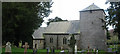
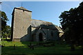
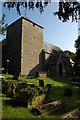
Early Medieval (Dark Age)Site Name: The Cross of Briamail (Llandefaelog) Alternative Name: St Briamael's Cross, St Maelog's CrossCountry: Wales
NOTE: This site is 0.855 km away from the location you searched for.
County: Powys Type: Ancient Cross
Nearest Town: Brecon Nearest Village: Llandefaelog Fach
Map Ref: SO034324
Latitude: 51.981633N Longitude: 3.407953W
Condition:
| 5 | Perfect |
| 4 | Almost Perfect |
| 3 | Reasonable but with some damage |
| 2 | Ruined but still recognisable as an ancient site |
| 1 | Pretty much destroyed, possibly visible as crop marks |
| 0 | No data. |
| -1 | Completely destroyed |
| 5 | Superb |
| 4 | Good |
| 3 | Ordinary |
| 2 | Not Good |
| 1 | Awful |
| 0 | No data. |
| 5 | Can be driven to, probably with disabled access |
| 4 | Short walk on a footpath |
| 3 | Requiring a bit more of a walk |
| 2 | A long walk |
| 1 | In the middle of nowhere, a nightmare to find |
| 0 | No data. |
| 5 | co-ordinates taken by GPS or official recorded co-ordinates |
| 4 | co-ordinates scaled from a detailed map |
| 3 | co-ordinates scaled from a bad map |
| 2 | co-ordinates of the nearest village |
| 1 | co-ordinates of the nearest town |
| 0 | no data |
Internal Links:
External Links:
 (PID:71419)")
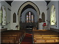
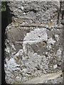
The cross-slab used to stand in the churchyard but today it is housed, for safety, under the north tower arch. It stands at 8 feet high and is said to date from the 8th-10th century CE; the date as been narrowed down to between 900-950. The slab has an incised Celtic cross at the top surrounded by ribbon interlacing and what could be a large "S". In the middle a warrior-like figure wears a long tunic and holds a spear and dagger in either hand. Below the figure a Latin inscription and, at the bottom, key-patterning decoration.
The inscription in two horizontal lines reads: BRIAMAIL FLOU or it could be FOR BRIAMAIL FLOU which translated says: 'The Cross of Briamail'. This could be a reference to St Briavel, the 6th century hermit of St Briavel's, Gloucestershire. Or it could be St Maelog, son of Caw Cawlwyd, a Clydeside chieftain, and brother of St Gildas the Historian.
There used to be another stone in the church here, but this is now lost. Apparently, it had an inscription to CATVC - probably St Cattwg or Cadoc. The writer Theophilus Jones recorded in 1890 the stone "has since disappeared".
You may be viewing yesterday's version of this page. To see the most up to date information please register for a free account.
Do not use the above information on other web sites or publications without permission of the contributor.
Nearby Images from Geograph Britain and Ireland:
©2006(licence)
©2006(licence)
©2008(licence)
©2015(licence)
©2008(licence)
The above images may not be of the site on this page, they are loaded from Geograph.
Please Submit an Image of this site or go out and take one for us!
Click here to see more info for this site
Nearby sites
Key: Red: member's photo, Blue: 3rd party photo, Yellow: other image, Green: no photo - please go there and take one, Grey: site destroyed
Download sites to:
KML (Google Earth)
GPX (GPS waypoints)
CSV (Garmin/Navman)
CSV (Excel)
To unlock full downloads you need to sign up as a Contributory Member. Otherwise downloads are limited to 50 sites.
Turn off the page maps and other distractions
Nearby sites listing. In the following links * = Image available
2.1km SSW 191° Pen-y-Crug Hillfort* Hillfort (SO02943033)
2.7km SE 127° Bishop Gower's Well* Holy Well or Sacred Spring (SO0551330776)
2.7km WNW 289° Battle Hill Cairn 2* Cairn (SO00853331)
2.7km WNW 288° Battle Hill Cairn 1* Cairn (SO00833328)
2.8km SW 217° Fennifach* Standing Stone (Menhir) (SO017302)
2.8km SSE 169° Maen-Du Well* Holy Well or Sacred Spring (SO03902963)
3.3km WSW 236° Battle (Powys)* Standing Stone (Menhir) (SO0062730638)
3.4km NE 34° Twyn-y-Gaer (Llaneglwys)* Hillfort (SO054352)
3.5km SSE 160° Priory Well (Powys)* Holy Well or Sacred Spring (SO04522906)
3.6km SSW 213° Coed Fenn-Fach* Hillfort (SO014294)
4.2km SSE 165° Brecknock Museum* Museum (SO044283)
4.6km SSE 150° Slwch Camp* Hillfort (SO056284)
4.8km SSW 206° St Cattwg's Church (Llanspyddid)* Early Christian Sculptured Stone (SO01192818)
4.9km WSW 247° Aberyscir* Ring Cairn (SN98883057)
4.9km NNW 328° Gaer Fach (Merthyr Cynog)* Hillfort (SO00913663)
5.7km SE 124° Twyn-Llechfaen* Hillfort (SO081291)
5.7km WNW 300° Carn y Fan* Hillfort (SN985354)
5.7km NNW 346° Gaer Fawr (Lower Chapel)* Hillfort (SO021380)
6.2km SW 224° Twyn-y-Gaer (Llanspyddid)* Hillfort (SN990280)
6.6km WSW 253° Twyn-y-Gaer (Trallong)* Hillfort (SN970306)
6.9km N 356° Bailey Bach* Ring Cairn (SO0304639278)
7.2km NNW 330° Llwyn Llwyd* Ancient Village or Settlement (SN99963869)
7.3km S 173° Coed Mawr Hillfort* Hillfort (SO04102512)
7.3km WSW 246° St David's Church (Trallong)* Early Christian Sculptured Stone (SN966296)
7.5km N 357° Cefn Clawdd CairnIII* Cairn (SO03123985)
View more nearby sites and additional images


 We would like to know more about this location. Please feel free to add a brief description and any relevant information in your own language.
 Wir möchten mehr über diese Stätte erfahren. Bitte zögern Sie nicht, eine kurze Beschreibung und relevante Informationen in Deutsch hinzuzufügen.
 Nous aimerions en savoir encore un peu sur les lieux. S'il vous plaît n'hesitez pas à ajouter une courte description et tous les renseignements pertinents dans votre propre langue.
 Quisieramos informarnos un poco más de las lugares. No dude en añadir una breve descripción y otros datos relevantes en su propio idioma.
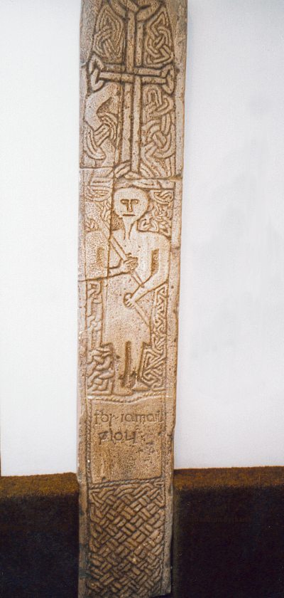