<< Our Photo Pages >> Burrian (Corrigall) - Broch or Nuraghe in Scotland in Orkney
Submitted by howar on Wednesday, 11 April 2007 Page Views: 4419
Iron Age and Later PrehistorySite Name: Burrian (Corrigall) Alternative Name: Corrigall BurnCountry: Scotland County: Orkney Type: Broch or Nuraghe
Nearest Town: Finstown Nearest Village: Dounby
Map Ref: HY32351937
Latitude: 59.055924N Longitude: 3.181155W
Condition:
| 5 | Perfect |
| 4 | Almost Perfect |
| 3 | Reasonable but with some damage |
| 2 | Ruined but still recognisable as an ancient site |
| 1 | Pretty much destroyed, possibly visible as crop marks |
| 0 | No data. |
| -1 | Completely destroyed |
| 5 | Superb |
| 4 | Good |
| 3 | Ordinary |
| 2 | Not Good |
| 1 | Awful |
| 0 | No data. |
| 5 | Can be driven to, probably with disabled access |
| 4 | Short walk on a footpath |
| 3 | Requiring a bit more of a walk |
| 2 | A long walk |
| 1 | In the middle of nowhere, a nightmare to find |
| 0 | No data. |
| 5 | co-ordinates taken by GPS or official recorded co-ordinates |
| 4 | co-ordinates scaled from a detailed map |
| 3 | co-ordinates scaled from a bad map |
| 2 | co-ordinates of the nearest village |
| 1 | co-ordinates of the nearest town |
| 0 | no data |
Internal Links:
External Links:
 (PID:28688)")
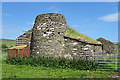
RCAHMS NMRS record no. HY31NW 33 is sheltered by the deep defile of the Burn of Corrigall at the south of the site but has been extensively (though fortunately not thoroughly) quarried in parts. The ground plan's asymmetry resembles broch villages such as Aikerness (Gurness) and Lingro on a slightly smaller scale - on the order of Round Howe in overall size. The external diameter is in the region of 53' with an estimated eight foot thick wall. Where the ditch about the broch is deeper, six drystane courses 4'6" high with an apparently completely vertical inner wall-face can still be seen over an 8' stretch, elsewhere the foundations survive in a couple of places. At one time a fairly extensive passage 2' wide came to light during farm works - the farmer having removed the stone infill then replaced this. A 33' wide ditch appears to surround about half the central broch, being 40' from it. This ditch is deeper at the north and north-west then comes to a sharp halt at the NE due to agricultural processes having levelled the ground. On its western lip an earthen bank still stands from 2'6"-5'6", and now spreads about 9' across. Between broch and ditch at all sides but the south are indeterminate walls, mutilation and ground disturbance obscuring the nature of the auxillary buildings there.
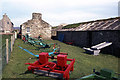
Unfortunately persistent rain prevented my approach to any nearer than the fieldgate beween the museum and the farmhouse, but if you have transport and ruinous mounds are your thing it is well worth a visit. Best ask at Corrigall Farm Museum or the farmhouse for permission I think.
You may be viewing yesterday's version of this page. To see the most up to date information please register for a free account.
 (PID:28692)")
 (PID:28691)")
 (PID:28690)")
 (PID:28689)")
Do not use the above information on other web sites or publications without permission of the contributor.
Nearby Images from Geograph Britain and Ireland:
©2018(licence)
©2005(licence)
©2020(licence)
©2013(licence)
©2013(licence)
The above images may not be of the site on this page, they are loaded from Geograph.
Please Submit an Image of this site or go out and take one for us!
Click here to see more info for this site
Nearby sites
Key: Red: member's photo, Blue: 3rd party photo, Yellow: other image, Green: no photo - please go there and take one, Grey: site destroyed
Download sites to:
KML (Google Earth)
GPX (GPS waypoints)
CSV (Garmin/Navman)
CSV (Excel)
To unlock full downloads you need to sign up as a Contributory Member. Otherwise downloads are limited to 50 sites.
Turn off the page maps and other distractions
Nearby sites listing. In the following links * = Image available
611m WSW 243° Howen Broch Broch or Nuraghe (HY318191)
852m WNW 302° Nisthouse Barrow Cemetery (HY31631983)
1.5km WSW 250° Uvigar* Artificial Mound (HY30951888)
1.6km WNW 292° North Bigging* Broch or Nuraghe (HY3082420003)
1.7km W 260° Foldarol's Hole* Artificial Mound (HY30631909)
1.8km W 263° Knowe of Browsky* Artificial Mound (HY306192)
1.8km SSW 213° Overbrough* Broch or Nuraghe (HY31361790)
2.0km S 180° Nettletar* Broch or Nuraghe (HY32321741)
2.0km W 271° Laxhowe* Artificial Mound (HY30361943)
2.1km WNW 295° Holodyke Cairn (HY30482028)
2.3km SSW 193° Caperhouse* Standing Stones (HY318171)
2.6km SE 136° Knowes of Trotty* Barrow Cemetery (HY341175)
2.9km WSW 248° Burrian (Russland)* Broch or Nuraghe (HY29641835)
3.0km SSW 210° Knowe of Burrian (Garth Farm)* Broch or Nuraghe (HY30821680)
3.1km SSW 202° Maesquoy* Standing Stones (HY311165)
3.2km S 174° Appiehouse* Standing Stone (Menhir) (HY32621620)
3.5km S 172° Woodwyn* Cairn (HY32781594)
3.5km W 272° Hourston* Crannog (HY28891957)
3.5km SSW 207° Knowe of Gullow* Broch or Nuraghe (HY307163)
3.5km S 191° Staney Hill* Chambered Tomb (HY316159)
3.7km E 100° The Lyde Stones* Standing Stone (Menhir) (HY3596718643)
3.8km S 184° Staney stone* Standing Stone (Menhir) (HY320156)
3.9km S 183° Venus of the Whins* Round Barrow(s) (HY321155)
3.9km S 188° Feolquoy* Round Barrow(s) (HY31741551)
4.1km SSE 168° Dale Souterrain* Artificial Mound (HY33111538)
View more nearby sites and additional images


 We would like to know more about this location. Please feel free to add a brief description and any relevant information in your own language.
 Wir möchten mehr über diese Stätte erfahren. Bitte zögern Sie nicht, eine kurze Beschreibung und relevante Informationen in Deutsch hinzuzufügen.
 Nous aimerions en savoir encore un peu sur les lieux. S'il vous plaît n'hesitez pas à ajouter une courte description et tous les renseignements pertinents dans votre propre langue.
 Quisieramos informarnos un poco más de las lugares. No dude en añadir una breve descripción y otros datos relevantes en su propio idioma.