<< Our Photo Pages >> Pen Alltmawr Cairns - Cairn in Wales in Powys
Submitted by dooclay on Thursday, 20 April 2023 Page Views: 424
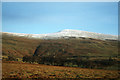
Neolithic and Bronze AgeSite Name: Pen Alltmawr CairnsCountry: Wales County: Powys Type: Cairn
Nearest Town: Crickhowell
Map Ref: SO2069024330
Latitude: 51.911833N Longitude: 3.154399W
Condition:
| 5 | Perfect |
| 4 | Almost Perfect |
| 3 | Reasonable but with some damage |
| 2 | Ruined but still recognisable as an ancient site |
| 1 | Pretty much destroyed, possibly visible as crop marks |
| 0 | No data. |
| -1 | Completely destroyed |
| 5 | Superb |
| 4 | Good |
| 3 | Ordinary |
| 2 | Not Good |
| 1 | Awful |
| 0 | No data. |
| 5 | Can be driven to, probably with disabled access |
| 4 | Short walk on a footpath |
| 3 | Requiring a bit more of a walk |
| 2 | A long walk |
| 1 | In the middle of nowhere, a nightmare to find |
| 0 | No data. |
| 5 | co-ordinates taken by GPS or official recorded co-ordinates |
| 4 | co-ordinates scaled from a detailed map |
| 3 | co-ordinates scaled from a bad map |
| 2 | co-ordinates of the nearest village |
| 1 | co-ordinates of the nearest town |
| 0 | no data |
Internal Links:
External Links:
")
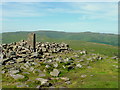
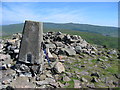
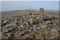
From Coflein: A ruined cairn, 12.5m in diameter and 0.5m high, a sheep shelter built into the N and an OS triangulation pillar is set on the S part.
Given that it is referred to as Cairn II, there must be at least one more I did not see.
You may be viewing yesterday's version of this page. To see the most up to date information please register for a free account.
")
Do not use the above information on other web sites or publications without permission of the contributor.
Nearby Images from Geograph Britain and Ireland:
©2007(licence)
©2012(licence)
©2013(licence)
©2011(licence)
©2020(licence)
The above images may not be of the site on this page, they are loaded from Geograph.
Please Submit an Image of this site or go out and take one for us!
Click here to see more info for this site
Nearby sites
Key: Red: member's photo, Blue: 3rd party photo, Yellow: other image, Green: no photo - please go there and take one, Grey: site destroyed
Download sites to:
KML (Google Earth)
GPX (GPS waypoints)
CSV (Garmin/Navman)
CSV (Excel)
To unlock full downloads you need to sign up as a Contributory Member. Otherwise downloads are limited to 50 sites.
Turn off the page maps and other distractions
Nearby sites listing. In the following links * = Image available
1.2km SSW 203° Pen Gloch Y Pibwr* Cairn (SO2020123205)
2.2km SSE 152° Pen Cerrig-calch* Cairn (SO21702236)
2.7km WSW 259° Llanfihangel Cwmdu* Ancient Cross (SO18052384)
3.1km W 269° Coed y Gaer Cairn Cairn (SO1759324348)
3.1km W 263° Coed y Gaer Hillfort (SO176240)
3.1km S 181° Craig Llwyn* Ancient Village or Settlement (SO206212)
3.6km SW 227° Tretower* Standing Stone (Menhir) (SO180219)
3.8km NNE 29° Maen Llwyd (Powys)* Standing Stone (Menhir) (SO22602762)
4.1km SSE 151° Crug Hywel* Hillfort (SO226207)
4.1km W 263° Cwmdu Stone Circle (SO166239)
4.2km ENE 73° Nant Yr Ychen Round Cairn* Cairn (SO2476025470)
4.4km WNW 293° Mynydd Llangorse 2 Ring Cairn (SO166261)
4.4km WNW 293° Mynydd Llangorse 1 Ring Cairn (SO166261)
4.5km SW 234° Celtic Head, Middle Gaer Carving (SO16962172)
4.7km W 268° Cefn Moel Stone Row / Alignment (SO15932421)
4.9km SW 221° Myarth Camp Hillfort (SO174207)
5.0km NNW 347° Pen Trumau Ring Cairn (SO196292)
5.1km SSW 207° Penmyarth* Standing Stone (Menhir) (SO18291986)
5.1km W 262° Cefn Moel Round Barrow(s) (SO156237)
5.1km S 174° Gwernvale* Chambered Tomb (SO2111119217)
5.3km E 99° Disgwylfa, Cairn I* Cairn (SO2597023440)
5.3km NNW 331° Ty-Isaf* Chambered Tomb (SO18182906)
5.5km WSW 254° Bwlch Ring Cairn* Ring Cairn (SO154229)
5.6km NNW 334° Cwm Fforest Modern Stone Circle etc (SO1833029440)
5.7km S 180° Llan-Wysg Well* Holy Well or Sacred Spring (SO2060318584)
View more nearby sites and additional images


 We would like to know more about this location. Please feel free to add a brief description and any relevant information in your own language.
 Wir möchten mehr über diese Stätte erfahren. Bitte zögern Sie nicht, eine kurze Beschreibung und relevante Informationen in Deutsch hinzuzufügen.
 Nous aimerions en savoir encore un peu sur les lieux. S'il vous plaît n'hesitez pas à ajouter une courte description et tous les renseignements pertinents dans votre propre langue.
 Quisieramos informarnos un poco más de las lugares. No dude en añadir una breve descripción y otros datos relevantes en su propio idioma.