<< Our Photo Pages >> Barntalloch (Langholm) - Misc. Earthwork in Scotland in Scottish Borders
Submitted by Anne T on Thursday, 27 July 2017 Page Views: 2214
Multi-periodSite Name: Barntalloch (Langholm) Alternative Name: Staplegordon Motte; Staplegorton; Portholm PoolCountry: Scotland
NOTE: This site is 1.643 km away from the location you searched for.
County: Scottish Borders Type: Misc. Earthwork
Nearest Town: Langholm Nearest Village: Staplegordon
Map Ref: NY35258776
Latitude: 55.179874N Longitude: 3.0183W
Condition:
| 5 | Perfect |
| 4 | Almost Perfect |
| 3 | Reasonable but with some damage |
| 2 | Ruined but still recognisable as an ancient site |
| 1 | Pretty much destroyed, possibly visible as crop marks |
| 0 | No data. |
| -1 | Completely destroyed |
| 5 | Superb |
| 4 | Good |
| 3 | Ordinary |
| 2 | Not Good |
| 1 | Awful |
| 0 | No data. |
| 5 | Can be driven to, probably with disabled access |
| 4 | Short walk on a footpath |
| 3 | Requiring a bit more of a walk |
| 2 | A long walk |
| 1 | In the middle of nowhere, a nightmare to find |
| 0 | No data. |
| 5 | co-ordinates taken by GPS or official recorded co-ordinates |
| 4 | co-ordinates scaled from a detailed map |
| 3 | co-ordinates scaled from a bad map |
| 2 | co-ordinates of the nearest village |
| 1 | co-ordinates of the nearest town |
| 0 | no data |
Internal Links:
External Links:
I have visited· I would like to visit
Anne T visited on 24th Jul 2017 - their rating: Cond: 2 Amb: 3 Access: 5 Barntalloch Motte, Staplegordon, Langholm: It was dull and very wet at our house, and fed up of the rain, we decided to head off to the Scottish Borders for some sunny, 25 deg C weather. Landing in Langholm by 2.30pm, we stopped off for coffee and cake before heading off into the wilds of Eskdale.
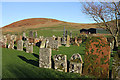
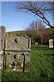
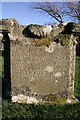
I spotted this site on the map, just west of Langholm, down a small road leading to a hamlet called Staplegordon. It caught my eye because it not only had the motte but the remains of a chapel. I like looking around the gravestones.
We parked in what looked like a parking area for fishermen to the right of the far side of the bridge. There is actually another car park by the farm nearer to the motte. There are posts indicating the routes of different Langholm Walks.
Just past the farm to the left of the bridge, the track splits at NY 35445 87796. The northern section leads down to the old graveyard and a bungalow (looks like the chapel was converted into a dwelling). A track led through another farmyard to our left which curls to the south west, around the side of the motte.
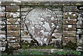
The lady farmer roared up on her quad bike and stopped to say hello. She didn’t seem to mind us tramping through her farmyard, but wasn’t very forthcoming. When I got home and did some research on Canmore, I found out that the old chapel was supposed to have an inscribed stone. We didn’t walk down there as we couldn’t see a way of reaching the churchyard except through the main gate of the cottage.
 (PID:168319)")
This motte is recorded as Canmore ID 67601, which tells us it was created in the second half of the 12th century by Galfrid or Geoffrey de Coninsburgh. It sits on top of a small cliff which has the River Esk on its southern side and the Staplegordon Burn to its east, and its south western edge shows signs of ongoing erosion by the Esk.
The Canmore entry tells us the motte is: "situated on a steep-sided promontory 120m SSE of Staplegordon burial-ground .....has been formed from the E tip of the promontory and is defended on the W by a ditch up to 12.5m broad; the triangular top of the motte measures 27m from ESE to WNW by 26m transversely and a fragment of mortared masonry is visible on its leading (W) edge. The bailey lies to the W and measures up to 57m from NE to SW by 37m transversely internally. It is defended on the S by the steep natural drop down to the river, but on the N and W there is a low rampart which has been spread up to 4m in thickness; the flanks of the promontory appear to have been scarped down to the level of the terrace that can be traced along the foot of the slope. The entrance to the bailey lies on the W but access to the motte may have been provided by a timber bridge spanning the ditch at the NE corner of the bailey, opposite which there is slight evidence of an entrance-way leading up to the summit."
To reach the hamlet of Staplegordon, take the B709 west out of Langholm then take the minor road which leads north from NY 34958 85731 to Staplegordon. Crossing the bridge over the River Esk, there are parking areas at NY 35572 87708 and by the farm at NY 35360 87836. At NY 35275 87861 the lane divides, the northern track leading towards the old chapel and burial ground (the chapel apparently has an inscribed stone within its bounds); the track to the south west curls around the side of the motte.
We met the farmer as we walked back, who was very friendly and didn't mind us visiting. If we'd hadn't seen so many mottes, we might have thought this was just a grass covered mound alongside the bend of the river, the but earth and stone construction visible on one side, together with its overall shape, made it easy to interpret.
You may be viewing yesterday's version of this page. To see the most up to date information please register for a free account.
 (PID:168323)")
 (PID:168322)")
 (PID:168321)")
 (PID:168320)")
Do not use the above information on other web sites or publications without permission of the contributor.
Nearby Images from Geograph Britain and Ireland:
©2010(licence)
©2010(licence)
©2009(licence)
©2009(licence)
©2009(licence)
The above images may not be of the site on this page, they are loaded from Geograph.
Please Submit an Image of this site or go out and take one for us!
Click here to see more info for this site
Nearby sites
Key: Red: member's photo, Blue: 3rd party photo, Yellow: other image, Green: no photo - please go there and take one, Grey: site destroyed
Download sites to:
KML (Google Earth)
GPX (GPS waypoints)
CSV (Garmin/Navman)
CSV (Excel)
To unlock full downloads you need to sign up as a Contributory Member. Otherwise downloads are limited to 50 sites.
Turn off the page maps and other distractions
Nearby sites listing. In the following links * = Image available
1.5km WNW 285° Little Hill (Craig)* Hillfort (NY3383088160)
4.8km WNW 297° Westerkirk Stone Circle (NY3190)
4.8km W 276° Shaw Hill (Westerkirk) Hillfort (NY30458834)
5.3km WNW 294° Boonies Ancient Village or Settlement (NY304900)
6.9km WNW 299° Bogle Walls* Hillfort (NY29249124)
7.7km SSW 196° Bloch Well (Langholm)* Holy Well or Sacred Spring (NY33018034)
8.1km ESE 106° Tinnis Hill* Cairn (NY43098545)
8.2km ESE 107° Tinnis Well* Holy Well or Sacred Spring (NY431852)
8.5km ESE 116° Windy Edge* Chambered Cairn (NY429839)
8.6km ESE 116° Windy Edge* Chambered Cairn (NY42958391)
8.7km ESE 116° Windy Edge Stone Stone Circle (NY43048389)
8.7km WNW 294° White Birren* Hillfort (NY27329148)
9.4km WNW 297° Green Hill (Lyneholm)* Misc. Earthwork (NY26939223)
9.7km SSE 161° Gilnochie Tower rock art* Rock Art (NY3823178559)
10.0km WNW 285° Bailiehill Fort* Hillfort (NY2558090520)
10.1km WNW 299° Bank Head Hill Ancient Village or Settlement (NY2648992760)
10.8km WNW 299° King Shaw's Grave* Cairn (NY25939320)
11.4km WNW 292° The Knowe* Ancient Village or Settlement (NY24799226)
12.1km WNW 297° Over Rig* Misc. Earthwork (NY2455693475)
12.1km WSW 250° Newhall Hill (Paddockhole)* Ancient Village or Settlement (NY23808372)
12.1km WNW 294° Castle O'er Fort* Hillfort (NY2419092850)
12.5km E 97° Milnholm (Newcastleton)* Ancient Cross (NY4763986111)
12.6km N 10° Wrangway Burn* Rock Art (NT377001)
12.8km W 271° Whitcastles* Stone Circle (NY22408806)
12.9km NW 306° Bessie's Hill Settlement Ancient Village or Settlement (NY249955)
View more nearby sites and additional images


 We would like to know more about this location. Please feel free to add a brief description and any relevant information in your own language.
 Wir möchten mehr über diese Stätte erfahren. Bitte zögern Sie nicht, eine kurze Beschreibung und relevante Informationen in Deutsch hinzuzufügen.
 Nous aimerions en savoir encore un peu sur les lieux. S'il vous plaît n'hesitez pas à ajouter une courte description et tous les renseignements pertinents dans votre propre langue.
 Quisieramos informarnos un poco más de las lugares. No dude en añadir una breve descripción y otros datos relevantes en su propio idioma.