


<< Our Photo Pages >> Caddonlee - Hillfort in Scotland in Scottish Borders
Submitted by h_fenton on Tuesday, 23 August 2011 Page Views: 5409
Iron Age and Later PrehistorySite Name: CaddonleeCountry: Scotland
NOTE: This site is 1.732 km away from the location you searched for.
County: Scottish Borders Type: Hillfort
Nearest Town: Galashiels Nearest Village: Clovenfords
Map Ref: NT43963551
Latitude: 55.609949N Longitude: 2.891149W
Condition:
| 5 | Perfect |
| 4 | Almost Perfect |
| 3 | Reasonable but with some damage |
| 2 | Ruined but still recognisable as an ancient site |
| 1 | Pretty much destroyed, possibly visible as crop marks |
| 0 | No data. |
| -1 | Completely destroyed |
| 5 | Superb |
| 4 | Good |
| 3 | Ordinary |
| 2 | Not Good |
| 1 | Awful |
| 0 | No data. |
| 5 | Can be driven to, probably with disabled access |
| 4 | Short walk on a footpath |
| 3 | Requiring a bit more of a walk |
| 2 | A long walk |
| 1 | In the middle of nowhere, a nightmare to find |
| 0 | No data. |
| 5 | co-ordinates taken by GPS or official recorded co-ordinates |
| 4 | co-ordinates scaled from a detailed map |
| 3 | co-ordinates scaled from a bad map |
| 2 | co-ordinates of the nearest village |
| 1 | co-ordinates of the nearest town |
| 0 | no data |
Be the first person to rate this site - see the 'Contribute!' box in the right hand menu.
Internal Links:
External Links:
I have visited· I would like to visit
h_fenton has visited here
")
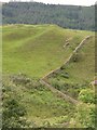
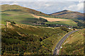
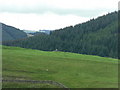
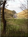
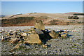
The principal visible remains are two sections of defences at the north eastern (two banks/ditches + wall) and south western (three banks/ditches) ends of the north western side of the hillfort, between the two sections of banks and ditches the site appears to just be protected by a steep slope.
Within the part of the hillfort not damaged by modern cultivation there are the traces of old cultivation (also outside the fort - especially to the north east) and a few more small banks.
The farmer has been using one of the ditches at the south western end as a dumping ground for boulders and stone which has probably been pulled from the arable field.
You may be viewing yesterday's version of this page. To see the most up to date information please register for a free account.
")
Do not use the above information on other web sites or publications without permission of the contributor.
Nearby Images from Geograph Britain and Ireland:
©2010(licence)
©2010(licence)
©2010(licence)
©2010(licence)
©2008(licence)
The above images may not be of the site on this page, they are loaded from Geograph.
Please Submit an Image of this site or go out and take one for us!
Click here to see more info for this site
Nearby sites
Key: Red: member's photo, Blue: 3rd party photo, Yellow: other image, Green: no photo - please go there and take one, Grey: site destroyed
Download sites to:
KML (Google Earth)
GPX (GPS waypoints)
CSV (Garmin/Navman)
CSV (Excel)
To unlock full downloads you need to sign up as a Contributory Member. Otherwise downloads are limited to 50 sites.
Turn off the page maps and other distractions
Nearby sites listing. In the following links * = Image available
3.9km NE 40° Torwoodlee* Broch or Nuraghe (NT46553847)
4.9km SE 124° Rink Hill (Boleside) Hillfort (NT48023270)
6.6km NNE 19° Bow Castle Broch* Broch or Nuraghe (NT4613541717)
7.6km NE 50° Hawksnest (Langshaw) Ring Cairn (NT499403)
8.3km SSE 155° Mungo's Well (Selkirk)* Holy Well or Sacred Spring (NT47342795)
8.5km WSW 256° Cheese Well* Holy Well or Sacred Spring (NT35693357)
8.5km SSE 152° Caulks Well (Selkirk)* Holy Well or Sacred Spring (NT4789127983)
8.5km N 10° Our Lady's Well (Borders)* Holy Well or Sacred Spring (NT45524386)
8.7km S 181° Tamlane's Well (Carterhaugh)* Holy Well or Sacred Spring (NT43742681)
11.5km SW 227° Warrior's Rest* Standing Stone (Menhir) (NT35452775)
11.7km SW 227° Glebe Stone* Standing Stone (Menhir) (NT3526227603)
11.8km ESE 103° Eildon Hill North* Hillfort (NT55453280)
11.9km NNE 14° Cathpair Standing Stone (Menhir) (NT47004700)
12.2km SW 228° The Yarrow Stone* Standing Stone (Menhir) (NT3480627444)
12.7km E 98° Rhymer's Stone (Melrose)* Marker Stone (NT5651833592)
13.1km E 94° Trimontium* Ancient Village or Settlement (NT57033435)
14.3km WNW 283° Cardrona* Standing Stone (Menhir) (NT30003895)
15.8km E 100° Font Stone (Dryburgh)* Ancient Cross (NT59543258)
16.2km ENE 74° Purveshaugh* Standing Stone (Menhir) (NT59663973)
17.3km ESE 105° Crystal Well (Benrig)* Holy Well or Sacred Spring (NT6064030847)
17.4km ESE 106° St Boswell's Old Church* Ancient Cross (NT6063730533)
17.4km ESE 106° Hier Well (Benrig)* Holy Well or Sacred Spring (NT60703042)
17.9km NE 52° Dods Corse Stone (Boon)* Ancient Cross (NT58214633)
17.9km E 88° Brothers' Stones* Standing Stones (NT61903600)
17.9km WSW 247° Douglas Water SE Stone Circle (NT273288)
View more nearby sites and additional images


 We would like to know more about this location. Please feel free to add a brief description and any relevant information in your own language.
 Wir möchten mehr über diese Stätte erfahren. Bitte zögern Sie nicht, eine kurze Beschreibung und relevante Informationen in Deutsch hinzuzufügen.
 Nous aimerions en savoir encore un peu sur les lieux. S'il vous plaît n'hesitez pas à ajouter une courte description et tous les renseignements pertinents dans votre propre langue.
 Quisieramos informarnos un poco más de las lugares. No dude en añadir una breve descripción y otros datos relevantes en su propio idioma.