


<< Our Photo Pages >> Scots' Dike - Misc. Earthwork in Scotland in Scottish Borders
Submitted by Anne T on Thursday, 17 May 2018 Page Views: 1587
Multi-periodSite Name: Scots' Dike Alternative Name: ScotsdikeCountry: Scotland County: Scottish Borders Type: Misc. Earthwork
Nearest Town: Longtown / Gretna Nearest Village: Netherby
Map Ref: NY38507325
Latitude: 55.049921N Longitude: 2.964128W
Condition:
| 5 | Perfect |
| 4 | Almost Perfect |
| 3 | Reasonable but with some damage |
| 2 | Ruined but still recognisable as an ancient site |
| 1 | Pretty much destroyed, possibly visible as crop marks |
| 0 | No data. |
| -1 | Completely destroyed |
| 5 | Superb |
| 4 | Good |
| 3 | Ordinary |
| 2 | Not Good |
| 1 | Awful |
| 0 | No data. |
| 5 | Can be driven to, probably with disabled access |
| 4 | Short walk on a footpath |
| 3 | Requiring a bit more of a walk |
| 2 | A long walk |
| 1 | In the middle of nowhere, a nightmare to find |
| 0 | No data. |
| 5 | co-ordinates taken by GPS or official recorded co-ordinates |
| 4 | co-ordinates scaled from a detailed map |
| 3 | co-ordinates scaled from a bad map |
| 2 | co-ordinates of the nearest village |
| 1 | co-ordinates of the nearest town |
| 0 | no data |
Be the first person to rate this site - see the 'Contribute!' box in the right hand menu.
Internal Links:
External Links:
")
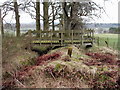
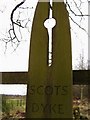
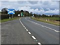
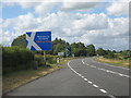
This earthwork, called alternatively Scots' Dike or Scotsdike, runs along a section of the border between England and Scotland, between the River Esk and the River Sark. It now lies within dense woodland known as Scotsdike Plantation and is formed by a bank with ditches on either side.
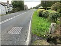
Recorded as Canmore ID 67548, this linear earthwork runs between NY 3307 7367 to NY 3872 7319. Its eastern end now lies immediately adjacent to the busy, fast A7, so we headed off to its western end, parking at NY 33500 74017, in a small layby at the corner of the plantation and a gate into a lane. At this point, a deep ditch runs north east/south west, with a second ditch alongside the western end of the plantation. This being the English side, there was no formal access, although it was possible to hop over the wire fence.
Not much to see, but interesting to stop and observe. The ditch at this western end was around 3m wide, and the bank around 1 metre high. We originally thought this earthwork was contemporary with the Antonine Wall, but it appears this section of the border was defined as late as 1552. Canmore notes that there seems to have been shifts in the course of the monument over time, indicating an earlier structure in place to mark an earlier boundary, which hs now been ploughed out. The terminal points used to be marked by boundary stones bearing the royal arms or England and Scotland.
You may be viewing yesterday's version of this page. To see the most up to date information please register for a free account.
")
Do not use the above information on other web sites or publications without permission of the contributor.
Nearby Images from Geograph Britain and Ireland:
©2007(licence)
©2007(licence)
©2022(licence)
©2018(licence)
©2010(licence)
The above images may not be of the site on this page, they are loaded from Geograph.
Please Submit an Image of this site or go out and take one for us!
Click here to see more info for this site
Nearby sites
Key: Red: member's photo, Blue: 3rd party photo, Yellow: other image, Green: no photo - please go there and take one, Grey: site destroyed
Download sites to:
KML (Google Earth)
GPX (GPS waypoints)
CSV (Garmin/Navman)
CSV (Excel)
To unlock full downloads you need to sign up as a Contributory Member. Otherwise downloads are limited to 50 sites.
Turn off the page maps and other distractions
Nearby sites listing. In the following links * = Image available
1.4km SSE 153° St Andrew's Well (Kirkandrews-on-Esk) Holy Well or Sacred Spring (NY3913071970)
2.0km SE 146° Castra Exploratorum Ancient Village or Settlement (NY39607160)
5.3km N 356° Gilnochie Tower rock art* Rock Art (NY3823178559)
5.5km S 185° St Michael's Holy Well* Holy Well or Sacred Spring (NY3789967755)
5.6km S 185° Arthuret Church cross* Ancient Cross (NY37936766)
6.8km W 279° Half Morton Cursus Cursus (NY31807440)
6.9km W 280° Half Morton Cursus Cursus (NY31707459)
8.1km ENE 62° Priest's Well (Catlowdy)* Holy Well or Sacred Spring (NY4573976887)
8.2km ENE 73° Solport Holy Well (Catlowdy) Holy Well or Sacred Spring (NY4637075490)
8.3km ENE 73° Holywell (Catlowdy)* Holy Well or Sacred Spring (NY4649175570)
8.4km SW 231° Gretna Sculptured Stone (NY319680)
9.0km NW 322° Bloch Well (Langholm)* Holy Well or Sacred Spring (NY33018034)
10.3km SW 224° Lochmaben Stane* Standing Stone (Menhir) (NY3123665983)
11.1km WSW 248° Mossknowe 2* Cairn (NY2806469266)
11.3km WSW 250° Mossknowe Tumulus* Cairn (NY27836948)
11.3km WSW 248° Mossknowe 3* Cairn (NY2793169102)
11.5km NNE 22° Windy Edge* Chambered Cairn (NY429839)
11.5km NNE 22° Windy Edge* Chambered Cairn (NY42958391)
11.6km NNE 22° Windy Edge Stone Stone Circle (NY43048389)
11.9km SSW 192° Rockcliffe (Cumbria)* Ancient Cross (NY35896162)
12.0km E 99° Bride's Well (Stapleton)* Holy Well or Sacred Spring (NY50397119)
12.8km NNE 20° Tinnis Well* Holy Well or Sacred Spring (NY431852)
13.0km NNE 20° Tinnis Hill* Cairn (NY43098545)
13.3km NE 42° Will O'Greena's Stane* Standing Stone (Menhir) (NY47578303)
13.6km W 278° Fair Helen's Tombstone* Marker Stone (NY25037534)
View more nearby sites and additional images


 We would like to know more about this location. Please feel free to add a brief description and any relevant information in your own language.
 Wir möchten mehr über diese Stätte erfahren. Bitte zögern Sie nicht, eine kurze Beschreibung und relevante Informationen in Deutsch hinzuzufügen.
 Nous aimerions en savoir encore un peu sur les lieux. S'il vous plaît n'hesitez pas à ajouter une courte description et tous les renseignements pertinents dans votre propre langue.
 Quisieramos informarnos un poco más de las lugares. No dude en añadir una breve descripción y otros datos relevantes en su propio idioma.