


<< Our Photo Pages >> Clevedon Sheila Na Gig - Carving in England in Somerset
Submitted by dooclay on Saturday, 13 May 2023 Page Views: 339
Multi-periodSite Name: Clevedon Sheila Na Gig Alternative Name: St Andrews Church Sheila Na GigCountry: England County: Somerset Type: Carving
Nearest Town: Clevedon
Map Ref: ST3938370827
Latitude: 51.433186N Longitude: 2.873381W
Condition:
| 5 | Perfect |
| 4 | Almost Perfect |
| 3 | Reasonable but with some damage |
| 2 | Ruined but still recognisable as an ancient site |
| 1 | Pretty much destroyed, possibly visible as crop marks |
| 0 | No data. |
| -1 | Completely destroyed |
| 5 | Superb |
| 4 | Good |
| 3 | Ordinary |
| 2 | Not Good |
| 1 | Awful |
| 0 | No data. |
| 5 | Can be driven to, probably with disabled access |
| 4 | Short walk on a footpath |
| 3 | Requiring a bit more of a walk |
| 2 | A long walk |
| 1 | In the middle of nowhere, a nightmare to find |
| 0 | No data. |
| 5 | co-ordinates taken by GPS or official recorded co-ordinates |
| 4 | co-ordinates scaled from a detailed map |
| 3 | co-ordinates scaled from a bad map |
| 2 | co-ordinates of the nearest village |
| 1 | co-ordinates of the nearest town |
| 0 | no data |
Internal Links:
External Links:
")
Taken from the Sheila Na Gig Project website:
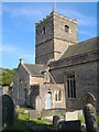
The alleged sheela figure can be found on the right hand side of the church as you walk in through the main gate. It is one of a number of corbels which are just above head height under the eaves of the church roof. The figure hold a foot in each hand in an acrobatic position which is very similar to a figure in Lower Swell. There are no immediate genitals visible but there is a small cleft in the middle of the groin and there also appears to be the remains of a large cigar shaped area of stone immediately in between the legs. This could indicate that the carving has been defaced at some time. If this was originally a vulva then it would be similar in relative size to the Oaksey Sheela however it could equally be a mega-phallic male. Unfortunately it is now too worn to be sure either way
You may be viewing yesterday's version of this page. To see the most up to date information please register for a free account.
Do not use the above information on other web sites or publications without permission of the contributor.
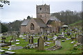
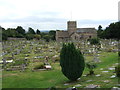
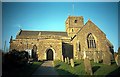
Nearby Images from Geograph Britain and Ireland:
©2019(licence)
©2011(licence)
©2012(licence)

©2015(licence)
©2018(licence)
The above images may not be of the site on this page, they are loaded from Geograph.
Please Submit an Image of this site or go out and take one for us!
Click here to see more info for this site
Nearby sites
Key: Red: member's photo, Blue: 3rd party photo, Yellow: other image, Green: no photo - please go there and take one, Grey: site destroyed
Download sites to:
KML (Google Earth)
GPX (GPS waypoints)
CSV (Garmin/Navman)
CSV (Excel)
To unlock full downloads you need to sign up as a Contributory Member. Otherwise downloads are limited to 50 sites.
Turn off the page maps and other distractions
Nearby sites listing. In the following links * = Image available
27m SW 224° St Andrews Churchyard Cross* Ancient Cross (ST3936470808)
345m WSW 240° Wain's Hill* Promontory Fort / Cliff Castle (ST39087066)
2.4km NE 40° Walton St Mary Cross Ancient Cross (ST4096172635)
2.9km SE 129° Kenn Churchyard Cross* Ancient Cross (ST4159968963)
3.0km NE 46° Walton Hill Fort Hillfort (ST41597292)
4.0km SSE 167° Kingston Seymour Village Cross* Ancient Cross (ST4022366941)
4.0km S 169° Kingston Seymour Churchyard Cross* Ancient Cross (ST4010166846)
4.5km ENE 72° Tickenham Court Barrow* Round Barrow(s) (ST43697219)
4.5km NE 49° Walton-in-Gordano Banjo Enclosure* Misc. Earthwork (ST42847373)
6.1km SSW 206° Wick St Lawrence Village Cross* Ancient Cross (ST3660565388)
6.2km SW 229° Middle Hope Round Barrow(s) (ST34656676)
6.2km ENE 74° Cadbury Camp* Hillfort (ST45427245)
6.3km SW 230° Woodspring Priory Field System Misc. Earthwork (ST345668)
6.4km E 84° Tickenham Churchyard Cross* Ancient Cross (ST4576771428)
6.6km ENE 72° West Park Wood Standing Stone* Modern Stone Circle etc (ST4564072821)
6.6km SE 145° Yatton Churchyard Cross* Ancient Cross (ST4312665395)
7.3km E 97° Nailsea Churchyard Cross* Ancient Cross (ST4660869917)
7.6km SE 140° Cadbury Hill* Hillfort (ST442649)
7.6km ESE 108° Chelvey Churchyard Cross* Ancient Cross (ST4662368354)
8.1km E 83° Whirley Pool* Holy Well or Sacred Spring (ST475717)
8.2km SSE 149° Congresbury Church Cross* Ancient Cross (ST4359863744)
8.2km SSE 148° Congresbury Village Cross* Ancient Cross (ST4373263818)
8.3km NE 53° St Mary's Well (Portishead)* Holy Well or Sacred Spring (ST46127575)
8.5km SE 125° Cleeve Hill Camp* Hillfort (ST46296590)
8.6km SE 126° Cleeve Toot Settlement Ancient Village or Settlement (ST463657)
View more nearby sites and additional images


 We would like to know more about this location. Please feel free to add a brief description and any relevant information in your own language.
 Wir möchten mehr über diese Stätte erfahren. Bitte zögern Sie nicht, eine kurze Beschreibung und relevante Informationen in Deutsch hinzuzufügen.
 Nous aimerions en savoir encore un peu sur les lieux. S'il vous plaît n'hesitez pas à ajouter une courte description et tous les renseignements pertinents dans votre propre langue.
 Quisieramos informarnos un poco más de las lugares. No dude en añadir una breve descripción y otros datos relevantes en su propio idioma.