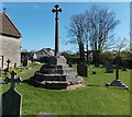
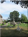
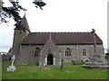
<< Our Photo Pages >> Kenn Churchyard Cross - Ancient Cross in England in Somerset
Submitted by dooclay on Friday, 12 May 2023 Page Views: 208
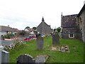
Early Medieval (Dark Age)Site Name: Kenn Churchyard CrossCountry: England County: Somerset Type: Ancient Cross
Nearest Town: Bristol Nearest Village: Kenn
Map Ref: ST4159968963
Latitude: 51.416660N Longitude: 2.841199W
Condition:
| 5 | Perfect |
| 4 | Almost Perfect |
| 3 | Reasonable but with some damage |
| 2 | Ruined but still recognisable as an ancient site |
| 1 | Pretty much destroyed, possibly visible as crop marks |
| 0 | No data. |
| -1 | Completely destroyed |
| 5 | Superb |
| 4 | Good |
| 3 | Ordinary |
| 2 | Not Good |
| 1 | Awful |
| 0 | No data. |
| 5 | Can be driven to, probably with disabled access |
| 4 | Short walk on a footpath |
| 3 | Requiring a bit more of a walk |
| 2 | A long walk |
| 1 | In the middle of nowhere, a nightmare to find |
| 0 | No data. |
| 5 | co-ordinates taken by GPS or official recorded co-ordinates |
| 4 | co-ordinates scaled from a detailed map |
| 3 | co-ordinates scaled from a bad map |
| 2 | co-ordinates of the nearest village |
| 1 | co-ordinates of the nearest town |
| 0 | no data |
Internal Links:
External Links:
")
A restored early 14th century Cross - head is modern
You may be viewing yesterday's version of this page. To see the most up to date information please register for a free account.
Do not use the above information on other web sites or publications without permission of the contributor.
Nearby Images from Geograph Britain and Ireland:
©2014(licence)
©2013(licence)
©2017(licence)
©2017(licence)
©2017(licence)
The above images may not be of the site on this page, they are loaded from Geograph.
Please Submit an Image of this site or go out and take one for us!
Click here to see more info for this site
Nearby sites
Key: Red: member's photo, Blue: 3rd party photo, Yellow: other image, Green: no photo - please go there and take one, Grey: site destroyed
Download sites to:
KML (Google Earth)
GPX (GPS waypoints)
CSV (Garmin/Navman)
CSV (Excel)
To unlock full downloads you need to sign up as a Contributory Member. Otherwise downloads are limited to 50 sites.
Turn off the page maps and other distractions
Nearby sites listing. In the following links * = Image available
2.4km SSW 214° Kingston Seymour Village Cross* Ancient Cross (ST4022366941)
2.6km SW 215° Kingston Seymour Churchyard Cross* Ancient Cross (ST4010166846)
2.9km NW 309° Clevedon Sheila Na Gig* Carving (ST3938370827)
2.9km NW 309° St Andrews Churchyard Cross* Ancient Cross (ST3936470808)
3.0km WNW 303° Wain's Hill* Promontory Fort / Cliff Castle (ST39087066)
3.7km N 350° Walton St Mary Cross Ancient Cross (ST4096172635)
3.8km NNE 32° Tickenham Court Barrow* Round Barrow(s) (ST43697219)
3.9km SSE 156° Yatton Churchyard Cross* Ancient Cross (ST4312665395)
4.0km N 359° Walton Hill Fort Hillfort (ST41597292)
4.8km SSE 147° Cadbury Hill* Hillfort (ST442649)
4.8km ENE 59° Tickenham Churchyard Cross* Ancient Cross (ST4576771428)
4.9km NNE 14° Walton-in-Gordano Banjo Enclosure* Misc. Earthwork (ST42847373)
5.0km E 96° Chelvey Churchyard Cross* Ancient Cross (ST4662368354)
5.1km ENE 79° Nailsea Churchyard Cross* Ancient Cross (ST4660869917)
5.2km NE 47° Cadbury Camp* Hillfort (ST45427245)
5.6km SSE 157° Congresbury Village Cross* Ancient Cross (ST4373263818)
5.6km NE 46° West Park Wood Standing Stone* Modern Stone Circle etc (ST4564072821)
5.6km SSE 158° Congresbury Church Cross* Ancient Cross (ST4359863744)
5.6km ESE 123° Cleeve Hill Camp* Hillfort (ST46296590)
5.7km SE 124° Cleeve Toot Settlement Ancient Village or Settlement (ST463657)
6.1km SW 234° Wick St Lawrence Village Cross* Ancient Cross (ST3660565388)
6.5km ESE 106° Tap's Combe Camp* Promontory Fort / Cliff Castle (ST47796708)
6.5km ENE 64° Whirley Pool* Holy Well or Sacred Spring (ST475717)
6.7km ESE 106° Chelvey Batch Settlement Ancient Village or Settlement (ST480670)
7.3km WSW 252° Middle Hope Round Barrow(s) (ST34656676)
View more nearby sites and additional images


 We would like to know more about this location. Please feel free to add a brief description and any relevant information in your own language.
 Wir möchten mehr über diese Stätte erfahren. Bitte zögern Sie nicht, eine kurze Beschreibung und relevante Informationen in Deutsch hinzuzufügen.
 Nous aimerions en savoir encore un peu sur les lieux. S'il vous plaît n'hesitez pas à ajouter une courte description et tous les renseignements pertinents dans votre propre langue.
 Quisieramos informarnos un poco más de las lugares. No dude en añadir una breve descripción y otros datos relevantes en su propio idioma.