


<< Our Photo Pages >> Wavering Down cairn - Round Cairn in England in Somerset
Submitted by TheCaptain on Tuesday, 13 November 2018 Page Views: 1090
Neolithic and Bronze AgeSite Name: Wavering Down cairn Alternative Name: Compton Bishop cairnCountry: England
NOTE: This site is 1.7 km away from the location you searched for.
County: Somerset Type: Round Cairn
Nearest Town: Cheddar Nearest Village: Compton Bishop
Map Ref: ST40705590
Latitude: 51.299121N Longitude: 2.851943W
Condition:
| 5 | Perfect |
| 4 | Almost Perfect |
| 3 | Reasonable but with some damage |
| 2 | Ruined but still recognisable as an ancient site |
| 1 | Pretty much destroyed, possibly visible as crop marks |
| 0 | No data. |
| -1 | Completely destroyed |
| 5 | Superb |
| 4 | Good |
| 3 | Ordinary |
| 2 | Not Good |
| 1 | Awful |
| 0 | No data. |
| 5 | Can be driven to, probably with disabled access |
| 4 | Short walk on a footpath |
| 3 | Requiring a bit more of a walk |
| 2 | A long walk |
| 1 | In the middle of nowhere, a nightmare to find |
| 0 | No data. |
| 5 | co-ordinates taken by GPS or official recorded co-ordinates |
| 4 | co-ordinates scaled from a detailed map |
| 3 | co-ordinates scaled from a bad map |
| 2 | co-ordinates of the nearest village |
| 1 | co-ordinates of the nearest town |
| 0 | no data |
Internal Links:
External Links:
I have visited· I would like to visit
TheCaptain has visited here
")
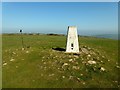
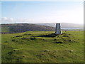
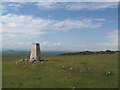
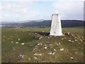
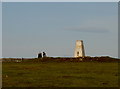
The round cairn has been dug into, and a trig point built on top of it.
Pastscape monument 194490.
Tremendous views on a good day.
You may be viewing yesterday's version of this page. To see the most up to date information please register for a free account.
")
Do not use the above information on other web sites or publications without permission of the contributor.
Nearby Images from Geograph Britain and Ireland:
©2012(licence)
©2011(licence)
©2012(licence)
©2014(licence)
©2017(licence)
The above images may not be of the site on this page, they are loaded from Geograph.
Please Submit an Image of this site or go out and take one for us!
Click here to see more info for this site
Nearby sites
Key: Red: member's photo, Blue: 3rd party photo, Yellow: other image, Green: no photo - please go there and take one, Grey: site destroyed
Download sites to:
KML (Google Earth)
GPX (GPS waypoints)
CSV (Garmin/Navman)
CSV (Excel)
To unlock full downloads you need to sign up as a Contributory Member. Otherwise downloads are limited to 50 sites.
Turn off the page maps and other distractions
Nearby sites listing. In the following links * = Image available
1.1km S 169° Compton Bishop* Standing Stones (ST409548)
1.2km WSW 244° Compton Bishop Church Cross* Ancient Cross (ST3959955378)
2.5km NW 319° Wook's Quoit* Standing Stone (Menhir) (ST39045783)
2.8km ESE 117° Axbridge Church Wells* Holy Well or Sacred Spring (ST432546)
3.1km W 268° Loxton Churchyard Cross* Ancient Cross (ST3762455813)
3.1km N 3° Banwell Camp Hillfort (ST409590)
3.2km NNW 343° Butstone (Banwell) Marker Stone (ST398590)
3.3km SSE 167° Weare Churchyard Cross* Ancient Cross (ST4140952670)
3.3km WNW 301° Flagstaff Hill* Stone Circle (ST3785257630)
3.5km SW 225° Biddisham Churchyard Cross* Ancient Cross (ST3819353429)
3.7km NE 45° The Wimblestone* Standing Stone (Menhir) (ST43355848)
4.3km WNW 285° Loxton Hill Barrows Round Barrow(s) (ST36565704)
4.9km ENE 59° Barrow at Rowberrow* Round Barrow(s) (ST44925834)
5.0km N 356° Banwell Moor Stone 2 Marker Stone (ST40406086)
5.1km ENE 76° Cuck Hill Barrow Round Barrow(s) (ST4567057030)
5.2km NE 54° Dolebury Camp* Hillfort (ST450589)
5.5km NNW 342° Banwell Moor Stone 1 Marker Stone (ST39036113)
5.7km NNW 339° Rolstone* Standing Stone (Menhir) (ST38736120)
5.7km S 177° Chapel Allerton Cross* Ancient Cross (ST4089050199)
6.0km ESE 110° Flint Jack's Cave Cave or Rock Shelter (ST463538)
6.1km NNW 349° Banwell Moor Stone 4 Marker Stone (ST39576188)
6.2km ESE 106° Sun Hole* Cave or Rock Shelter (ST467541)
6.3km ESE 108° Cheddar Museum of Prehistory* Museum (ST46655393)
6.3km E 85° Tynings Farm Barrow Group* Barrow Cemetery (ST47005635)
6.3km ESE 108° Goughs Cave (Cheddar)* Cave or Rock Shelter (ST46715392)
View more nearby sites and additional images


 We would like to know more about this location. Please feel free to add a brief description and any relevant information in your own language.
 Wir möchten mehr über diese Stätte erfahren. Bitte zögern Sie nicht, eine kurze Beschreibung und relevante Informationen in Deutsch hinzuzufügen.
 Nous aimerions en savoir encore un peu sur les lieux. S'il vous plaît n'hesitez pas à ajouter une courte description et tous les renseignements pertinents dans votre propre langue.
 Quisieramos informarnos un poco más de las lugares. No dude en añadir una breve descripción y otros datos relevantes en su propio idioma.