

<< Text Pages >> Threepow Raise Ring Cairn - Ring Cairn in England in Cumbria
Submitted by Anne T on Monday, 13 February 2023 Page Views: 1203
Neolithic and Bronze AgeSite Name: Threepow Raise Ring Cairn Alternative Name: Moordivock Cairn J; Moor Divock Cairn J; JQ 80Country: England County: Cumbria Type: Ring Cairn
Nearest Town: Penrith Nearest Village: Helton / Askham
Map Ref: NY4847721781
Latitude: 54.588581N Longitude: 2.798805W
Condition:
| 5 | Perfect |
| 4 | Almost Perfect |
| 3 | Reasonable but with some damage |
| 2 | Ruined but still recognisable as an ancient site |
| 1 | Pretty much destroyed, possibly visible as crop marks |
| 0 | No data. |
| -1 | Completely destroyed |
| 5 | Superb |
| 4 | Good |
| 3 | Ordinary |
| 2 | Not Good |
| 1 | Awful |
| 0 | No data. |
| 5 | Can be driven to, probably with disabled access |
| 4 | Short walk on a footpath |
| 3 | Requiring a bit more of a walk |
| 2 | A long walk |
| 1 | In the middle of nowhere, a nightmare to find |
| 0 | No data. |
| 5 | co-ordinates taken by GPS or official recorded co-ordinates |
| 4 | co-ordinates scaled from a detailed map |
| 3 | co-ordinates scaled from a bad map |
| 2 | co-ordinates of the nearest village |
| 1 | co-ordinates of the nearest town |
| 0 | no data |
Be the first person to rate this site - see the 'Contribute!' box in the right hand menu.
Internal Links:
External Links:
Ring Cairn in Cumbria
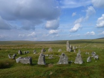
Recorded separately from the Cockpit Cairns/Threepow Raise Cairn Cemetery, this ring cairn is recorded as Historic England List ID 1011588, 'Ring cairn east of Threepow Raise'.
Historic England tells us: "The monument is a ring cairn located on an area of Moor Divock east of Threepow Raise. It includes a ring bank of largely turf-covered stones 1.2m - 1.6m wide and up to 0.2m high; it has an external diameter of 19.5m. The ring bank forms 270 degrees of a circle; there is a wide entrance with ill-defined edges in the bank's northern quadrant."
The cairn, along with a smaller cairn (not recorded by HE), is also identified as monument 80 in Jamie Quartermaine's "Askham Fell Survey Catalogue", in which he describes it as: "A large, low, regular, circular stone bank, with small to medium stones protruding from turf. It is slightly prominent and is moderately defined, however there is a large gap in the northern quadrant (c. 90 degrees). The edges of this gap are very ill-defined which may be an indication that it was not an entrance. It is located in a fairly flat non-undulating area; the area within is fairly flat and is at a similar elevation to that outside. It is possibly a ring cairn".
"To the west of the ring-cairn is a possible round cairn (c.3.7 x 3.4m x 0.15m) with substantial turf cover, however apart from this it is totally isolated and remote. Size: diameter of whole c.19.5m width of bank 1.2m-1.6m height of bank 0.1m-0.2m".
For a link to Quartermaine's report see our generic Askham Fell site page.
You may be viewing yesterday's version of this page. To see the most up to date information please register for a free account.
Do not use the above information on other web sites or publications without permission of the contributor.
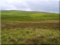
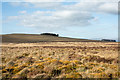
Nearby Images from Geograph Britain and Ireland:
©2008(licence)
©2016(licence)

©2014(licence)
©2014(licence)
©2012(licence)
The above images may not be of the site on this page, they are loaded from Geograph.
Please Submit an Image of this site or go out and take one for us!
Click here to see more info for this site
Nearby sites
Key: Red: member's photo, Blue: 3rd party photo, Yellow: other image, Green: no photo - please go there and take one, Grey: site destroyed
Download sites to:
KML (Google Earth)
GPX (GPS waypoints)
CSV (Garmin/Navman)
CSV (Excel)
To unlock full downloads you need to sign up as a Contributory Member. Otherwise downloads are limited to 50 sites.
Turn off the page maps and other distractions
Nearby sites listing. In the following links * = Image available
282m WNW 295° Threepow Raise Cairnfield Barrow Cemetery (NY4822221902)
315m N 9° Moor Divock Round Cairns K1, K2 and K3 Round Cairn (NY4853122092)
499m NNW 336° The Cockpit* Stone Circle (NY48282224)
540m NNW 337° Cockpit Cairns* Cairn (NY4826822280)
706m ENE 56° Moor Divock* Cairn (NY4907122166)
770m NNE 22° Moor Divock 12 Cairn (NY48782249)
780m NNE 23° Moor Divock 11 Cairn (NY4878522498)
780m NNE 30° White Raise Cairn* Cairn (NY48882245)
788m ENE 65° Moor Divock* Multiple Stone Rows / Avenue (NY492221)
802m N 2° Moor Divock Cairns G and H Cairn (NY4851622583)
812m NNE 33° Moor Divock Cairn E Cairn (NY4892522460)
840m ESE 102° Moor Divock Cairn* Cairn (NY493216)
843m NE 51° Moor Divock 9 Cairn (NY4914122304)
847m NE 51° Askham Fell Stone Row* Stone Row / Alignment (NY4914322307)
849m ENE 74° Moor Divock carved stone* Rock Art (NY493220)
857m NE 55° Moor Divock 6, 7 and 8 Cairn (NY49192226)
868m NNE 25° Moor Divock Cairn F Cairn (NY4885422564)
877m NE 44° Askham Fell* Cairn (NY491224)
900m E 81° Moor Divock 3* Cairn (NY4936921917)
916m ENE 63° Moor Divock 5* Cairn (NY4930322183)
921m ENE 62° Moor Divock Round Cairn D* Cairn (NY4929822204)
928m ENE 74° Moor Divock 4 to 5 Stone Avenue Stone Row / Alignment (NY4937322033)
930m ENE 65° Moor Divock Round Cairn C Cairn (NY4933022158)
937m ENE 78° Moor Divock 4* Stone Circle (NY49402196)
939m E 79° Askham Fell Cairn Stone Row* Stone Row / Alignment (NY4940321951)
View more nearby sites and additional images


 We would like to know more about this location. Please feel free to add a brief description and any relevant information in your own language.
 Wir möchten mehr über diese Stätte erfahren. Bitte zögern Sie nicht, eine kurze Beschreibung und relevante Informationen in Deutsch hinzuzufügen.
 Nous aimerions en savoir encore un peu sur les lieux. S'il vous plaît n'hesitez pas à ajouter une courte description et tous les renseignements pertinents dans votre propre langue.
 Quisieramos informarnos un poco más de las lugares. No dude en añadir una breve descripción y otros datos relevantes en su propio idioma.