<< Our Photo Pages >> Flax Bourton Ancient Cross - Ancient Cross in England in Somerset
Submitted by dooclay on Monday, 19 December 2022 Page Views: 2139
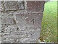
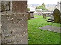
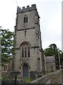
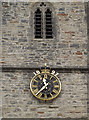
Early Medieval (Dark Age)Site Name: Flax Bourton Ancient CrossCountry: England County: Somerset Type: Ancient Cross
Nearest Town: Bristol Nearest Village: Flax Bourton
Map Ref: ST5066269369
Latitude: 51.421174N Longitude: 2.710941W
Condition:
| 5 | Perfect |
| 4 | Almost Perfect |
| 3 | Reasonable but with some damage |
| 2 | Ruined but still recognisable as an ancient site |
| 1 | Pretty much destroyed, possibly visible as crop marks |
| 0 | No data. |
| -1 | Completely destroyed |
| 5 | Superb |
| 4 | Good |
| 3 | Ordinary |
| 2 | Not Good |
| 1 | Awful |
| 0 | No data. |
| 5 | Can be driven to, probably with disabled access |
| 4 | Short walk on a footpath |
| 3 | Requiring a bit more of a walk |
| 2 | A long walk |
| 1 | In the middle of nowhere, a nightmare to find |
| 0 | No data. |
| 5 | co-ordinates taken by GPS or official recorded co-ordinates |
| 4 | co-ordinates scaled from a detailed map |
| 3 | co-ordinates scaled from a bad map |
| 2 | co-ordinates of the nearest village |
| 1 | co-ordinates of the nearest town |
| 0 | no data |
Internal Links:
External Links:
")
You may be viewing yesterday's version of this page. To see the most up to date information please register for a free account.
")
Do not use the above information on other web sites or publications without permission of the contributor.
Nearby Images from Geograph Britain and Ireland:
©2022(licence)

©2015(licence)
©2014(licence)
©2017(licence)
©2014(licence)
The above images may not be of the site on this page, they are loaded from Geograph.
Please Submit an Image of this site or go out and take one for us!
Click here to see more info for this site
Nearby sites
Key: Red: member's photo, Blue: 3rd party photo, Yellow: other image, Green: no photo - please go there and take one, Grey: site destroyed
Download sites to:
KML (Google Earth)
GPX (GPS waypoints)
CSV (Garmin/Navman)
CSV (Excel)
To unlock full downloads you need to sign up as a Contributory Member. Otherwise downloads are limited to 50 sites.
Turn off the page maps and other distractions
Nearby sites listing. In the following links * = Image available
1.7km SW 232° Backwell Church Cross* Ancient Cross (ST4931268323)
1.8km SW 223° Backwell Hillfort Hillfort (ST49406805)
2.0km SW 226° Backwell Cave* Cave or Rock Shelter (ST49246801)
2.6km ESE 106° Fairy Well (Barrow Gurney) Holy Well or Sacred Spring (ST532686)
2.9km NNE 28° Wraxall Camp* Ancient Village or Settlement (ST52057193)
3.1km NNW 327° Wraxhall Churchyard Cross* Ancient Cross (ST4902371945)
3.6km SW 228° Chelvey Batch Settlement Ancient Village or Settlement (ST480670)
3.7km SW 231° Tap's Combe Camp* Promontory Fort / Cliff Castle (ST47796708)
3.9km NW 306° Whirley Pool* Holy Well or Sacred Spring (ST475717)
4.1km W 277° Nailsea Churchyard Cross* Ancient Cross (ST4660869917)
4.2km WSW 255° Chelvey Churchyard Cross* Ancient Cross (ST4662368354)
4.2km SSE 156° Felton Village Bowl Barrow* Round Barrow(s) (ST52386550)
4.5km NE 35° Snake's Well and Spring* Holy Well or Sacred Spring (ST53287308)
4.6km SSE 167° Felton Hill Long Barrow T26* Chambered Tomb (ST51626491)
4.7km SSE 161° Felton Hill Bowl Barrow T30A* Round Barrow(s) (ST52126490)
4.7km SSE 165° Felton Common Suck Stone* Natural Stone / Erratic / Other Natural Feature (ST5187164800)
4.7km SSE 164° Felton Bowl Barrows T28 & T29* Round Barrow(s) (ST51966480)
5.0km ENE 71° Long Ashton Cross* Ancient Cross (ST5539070910)
5.0km S 186° The Waterstone* Burial Chamber or Dolmen (ST5006464403)
5.3km WNW 292° Tickenham Churchyard Cross* Ancient Cross (ST4576771428)
5.6km SW 231° Cleeve Hill Camp* Hillfort (ST46296590)
5.7km SW 229° Cleeve Toot Settlement Ancient Village or Settlement (ST463657)
5.8km N 352° Conygar Hillfort Hillfort (ST49897509)
5.8km S 186° Red Hill Longbarrow Chambered Tomb (ST49956361)
6.0km NE 39° Abbots Leigh Churchyard Cross* Ancient Cross (ST5445274007)
View more nearby sites and additional images


 We would like to know more about this location. Please feel free to add a brief description and any relevant information in your own language.
 Wir möchten mehr über diese Stätte erfahren. Bitte zögern Sie nicht, eine kurze Beschreibung und relevante Informationen in Deutsch hinzuzufügen.
 Nous aimerions en savoir encore un peu sur les lieux. S'il vous plaît n'hesitez pas à ajouter une courte description et tous les renseignements pertinents dans votre propre langue.
 Quisieramos informarnos un poco más de las lugares. No dude en añadir una breve descripción y otros datos relevantes en su propio idioma.