


<< Our Photo Pages >> Mutiny Stones - Cairn in Scotland in Scottish Borders
Submitted by mafenty on Thursday, 03 April 2008 Page Views: 5559
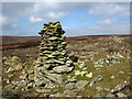
Neolithic and Bronze AgeSite Name: Mutiny Stones Alternative Name: Deil's Mitten Deil's MiddenCountry: Scotland County: Scottish Borders Type: Cairn
Nearest Town: Duns Nearest Village: Longformacus
Map Ref: NT62255902
Latitude: 55.822943N Longitude: 2.604085W
Condition:
| 5 | Perfect |
| 4 | Almost Perfect |
| 3 | Reasonable but with some damage |
| 2 | Ruined but still recognisable as an ancient site |
| 1 | Pretty much destroyed, possibly visible as crop marks |
| 0 | No data. |
| -1 | Completely destroyed |
| 5 | Superb |
| 4 | Good |
| 3 | Ordinary |
| 2 | Not Good |
| 1 | Awful |
| 0 | No data. |
| 5 | Can be driven to, probably with disabled access |
| 4 | Short walk on a footpath |
| 3 | Requiring a bit more of a walk |
| 2 | A long walk |
| 1 | In the middle of nowhere, a nightmare to find |
| 0 | No data. |
| 5 | co-ordinates taken by GPS or official recorded co-ordinates |
| 4 | co-ordinates scaled from a detailed map |
| 3 | co-ordinates scaled from a bad map |
| 2 | co-ordinates of the nearest village |
| 1 | co-ordinates of the nearest town |
| 0 | no data |
Internal Links:
External Links:
")
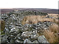
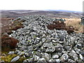
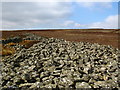
A long cairn, I think the only example in this area. May have been chambered but much of the original removed for dykes and sheep shelters Superb site on good day grouse, curlew, peewits, mountain hares and sky larks
"Mutiny" is a corruption of the old names "mitten" or "midden" probably just descriptive of a heap of stones
You may be viewing yesterday's version of this page. To see the most up to date information please register for a free account.
")
Do not use the above information on other web sites or publications without permission of the contributor.
Nearby Images from Geograph Britain and Ireland:
©2007(licence)
©2007(licence)
©2007(licence)
©2007(licence)
©2007(licence)
The above images may not be of the site on this page, they are loaded from Geograph.
Please Submit an Image of this site or go out and take one for us!
Click here to see more info for this site
Nearby sites
Key: Red: member's photo, Blue: 3rd party photo, Yellow: other image, Green: no photo - please go there and take one, Grey: site destroyed
Download sites to:
KML (Google Earth)
GPX (GPS waypoints)
CSV (Garmin/Navman)
CSV (Excel)
To unlock full downloads you need to sign up as a Contributory Member. Otherwise downloads are limited to 50 sites.
Turn off the page maps and other distractions
Nearby sites listing. In the following links * = Image available
4.3km S 178° Twin Law Cairns* Cairn (NT624547)
4.5km NNE 22° Chapel Stone (Penshiel Grange)* Stone Circle (NT64016317)
4.5km NNE 22° Penshiel Grange Stone Circle* Stone Circle (NT64016317)
5.0km S 175° Kingside Hill (Cranshaws) Stone Circle (NT62635403)
5.3km N 10° Penshiel Hill Stone Circle (NT632642)
5.5km NNE 23° Kell Burn Stone Circle (NT645641)
5.6km NNE 21° Whiteadder Reservoir* Cairn (NT64336421)
5.6km N 354° Mayshiel Stone Circle (NT617646)
5.7km N 7° Mayshiel Stone Circle* Stone Circle (NT62986465)
5.7km NNE 19° Packman's Grave (Whiteadder Reservoir) Stone Row / Alignment (NT64176439)
5.9km NE 45° Kilmade Hillfort* Hillfort (NT66456315)
6.0km N 3° Kingside Hill Stone Circle (NT62636503)
6.2km N 3° Stone Standing Stone Standing Stone (Menhir) (NT62586518)
6.2km N 356° Crow Stones (Cranshaws)* Stone Circle (NT61836519)
6.5km N 2° Nine Stones Rig* Stone Circle (NT62546549)
7.7km N 0° Tavers Cleugh* Cairn (NT62386671)
8.0km N 357° Ragstone Rig (Cranshaws) Stone Row / Alignment (NT61956705)
8.2km NNE 12° Spartleton Edge Stone Circle (NT640670)
8.8km NE 37° Bothwell Water (Cranshaws) Natural Stone / Erratic / Other Natural Feature (NT67656598)
8.9km NNE 20° Yadlee* Stone Circle (NT65406732)
9.3km SW 224° Borrowston Rigg* Stone Circle (NT5576052315)
9.3km SW 223° Borrowstone Rig* Stone Circle (NT55765231)
9.4km SW 223° Borrowstone Rig Round Cairn (NT55775223)
9.5km SSW 194° Bruntaburn Mill* Standing Stone (Menhir) (NT59814979)
9.6km N 354° White Castle Fort* Hillfort (NT61356860)
View more nearby sites and additional images


 We would like to know more about this location. Please feel free to add a brief description and any relevant information in your own language.
 Wir möchten mehr über diese Stätte erfahren. Bitte zögern Sie nicht, eine kurze Beschreibung und relevante Informationen in Deutsch hinzuzufügen.
 Nous aimerions en savoir encore un peu sur les lieux. S'il vous plaît n'hesitez pas à ajouter une courte description et tous les renseignements pertinents dans votre propre langue.
 Quisieramos informarnos un poco más de las lugares. No dude en añadir una breve descripción y otros datos relevantes en su propio idioma.