<< Our Photo Pages >> Staunton Cross - Ancient Cross in England in Gloucestershire
Submitted by dooclay on Monday, 14 August 2023 Page Views: 262
Early Medieval (Dark Age)Site Name: Staunton CrossCountry: England
NOTE: This site is 0.361 km away from the location you searched for.
County: Gloucestershire Type: Ancient Cross
Nearest Village: Staunton
Map Ref: SO5506412571
Latitude: 51.809957N Longitude: 2.653193W
Condition:
| 5 | Perfect |
| 4 | Almost Perfect |
| 3 | Reasonable but with some damage |
| 2 | Ruined but still recognisable as an ancient site |
| 1 | Pretty much destroyed, possibly visible as crop marks |
| 0 | No data. |
| -1 | Completely destroyed |
| 5 | Superb |
| 4 | Good |
| 3 | Ordinary |
| 2 | Not Good |
| 1 | Awful |
| 0 | No data. |
| 5 | Can be driven to, probably with disabled access |
| 4 | Short walk on a footpath |
| 3 | Requiring a bit more of a walk |
| 2 | A long walk |
| 1 | In the middle of nowhere, a nightmare to find |
| 0 | No data. |
| 5 | co-ordinates taken by GPS or official recorded co-ordinates |
| 4 | co-ordinates scaled from a detailed map |
| 3 | co-ordinates scaled from a bad map |
| 2 | co-ordinates of the nearest village |
| 1 | co-ordinates of the nearest town |
| 0 | no data |
Internal Links:
External Links:
")
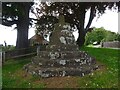
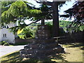
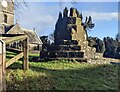
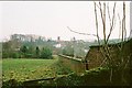
Base and broken shaft of a Medieval Village Cross opposite Staunton Church. There is a probable Roman Altar reused as a Font inside the Church.
You may be viewing yesterday's version of this page. To see the most up to date information please register for a free account.
")
Do not use the above information on other web sites or publications without permission of the contributor.
Nearby Images from Geograph Britain and Ireland:
©2023(licence)
©2010(licence)
©2024(licence)
©2024(licence)
©2010(licence)
The above images may not be of the site on this page, they are loaded from Geograph.
Please Submit an Image of this site or go out and take one for us!
Click here to see more info for this site
Nearby sites
Key: Red: member's photo, Blue: 3rd party photo, Yellow: other image, Green: no photo - please go there and take one, Grey: site destroyed
Download sites to:
KML (Google Earth)
GPX (GPS waypoints)
CSV (Garmin/Navman)
CSV (Excel)
To unlock full downloads you need to sign up as a Contributory Member. Otherwise downloads are limited to 50 sites.
Turn off the page maps and other distractions
Nearby sites listing. In the following links * = Image available
444m W 273° Toads Mouth Stone* Natural Stone / Erratic / Other Natural Feature (SO54621260)
951m WSW 246° The Virgins Cup* Natural Stone / Erratic / Other Natural Feature (SO54191219)
1.0km ESE 120° Long Stone, Staunton* Standing Stone (Menhir) (SO55931206)
1.0km WSW 248° The Buck Stone (Gloucestershire)* Rock Outcrop (SO541122)
1.3km W 263° Staunton Broadstones* Natural Stone / Erratic / Other Natural Feature (SO53741242)
1.5km N 6° Whipping Brook Cave Cave or Rock Shelter (SO55251410)
1.6km NNW 332° Near Hearkening Rock* Natural Stone / Erratic / Other Natural Feature (SO54311401)
1.7km NNW 329° Staunton Suck Stone (Gloucestershire)* Natural Stone / Erratic / Other Natural Feature (SO54211401)
1.9km N 2° The Biblins Cave Cave or Rock Shelter (SO55161446)
2.5km N 7° Biblins Cave or Rock Shelter (SO554150)
2.5km N 11° Lord's Wood Cave Cave or Rock Shelter (SO55551503)
2.7km NNW 339° Far Hearkening Rock* Natural Stone / Erratic / Other Natural Feature (SO5410515107)
2.7km N 351° Madawg Rockshelter Cave or Rock Shelter (SO54651526)
2.8km N 350° Cavall's Cave Cave or Rock Shelter (SO546153)
2.8km N 11° Merlin's Cave (Herefordshire) Cave or Rock Shelter (SO556153)
3.0km W 274° Kymin Hill Hillfort (SO521128)
3.0km NNE 12° Symonds Yat West Cave or Rock Shelter (SO55701555)
3.1km N 351° King Arthur's North* Cave or Rock Shelter (SO54601559)
3.1km NNE 19° Bowler's Hole Cave or Rock Shelter (SO56101545)
3.1km N 350° King Arthur's Cave* Cave or Rock Shelter (SO54561559)
3.1km S 175° Newland Crosses* Ancient Cross (SO5530809511)
3.2km NNE 19° Symonds Yat Cave Cave or Rock Shelter (SO56101555)
3.2km NNE 19° Symonds Yat Cave 2 Cave or Rock Shelter (SO56101555)
3.2km NNE 19° Wye Rapids Cave Cave or Rock Shelter (SO56101555)
3.2km NNE 19° Symonds Yat Cave 3 Cave or Rock Shelter (SO56101555)
View more nearby sites and additional images


 We would like to know more about this location. Please feel free to add a brief description and any relevant information in your own language.
 Wir möchten mehr über diese Stätte erfahren. Bitte zögern Sie nicht, eine kurze Beschreibung und relevante Informationen in Deutsch hinzuzufügen.
 Nous aimerions en savoir encore un peu sur les lieux. S'il vous plaît n'hesitez pas à ajouter une courte description et tous les renseignements pertinents dans votre propre langue.
 Quisieramos informarnos un poco más de las lugares. No dude en añadir una breve descripción y otros datos relevantes en su propio idioma.