<< Our Photo Pages >> St Oswald (Winwick) - Ancient Cross in England in Cheshire
Submitted by TimPrevett on Friday, 11 May 2007 Page Views: 9348
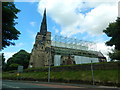
Early Medieval (Dark Age)Site Name: St Oswald (Winwick)Country: England County: Cheshire Type: Ancient Cross
Nearest Town: Warrington Nearest Village: Winwick
Map Ref: SJ6037592833
Latitude: 53.430784N Longitude: 2.59785W
Condition:
| 5 | Perfect |
| 4 | Almost Perfect |
| 3 | Reasonable but with some damage |
| 2 | Ruined but still recognisable as an ancient site |
| 1 | Pretty much destroyed, possibly visible as crop marks |
| 0 | No data. |
| -1 | Completely destroyed |
| 5 | Superb |
| 4 | Good |
| 3 | Ordinary |
| 2 | Not Good |
| 1 | Awful |
| 0 | No data. |
| 5 | Can be driven to, probably with disabled access |
| 4 | Short walk on a footpath |
| 3 | Requiring a bit more of a walk |
| 2 | A long walk |
| 1 | In the middle of nowhere, a nightmare to find |
| 0 | No data. |
| 5 | co-ordinates taken by GPS or official recorded co-ordinates |
| 4 | co-ordinates scaled from a detailed map |
| 3 | co-ordinates scaled from a bad map |
| 2 | co-ordinates of the nearest village |
| 1 | co-ordinates of the nearest town |
| 0 | no data |
Internal Links:
External Links:
 (PID:30228)")
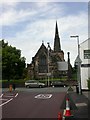
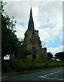
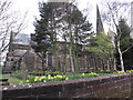
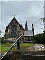
The central arm of a large cross now inside St Oswald's, Winwick, on the window sill of the Gerard Chapel. The remains of this Saxon cross are recorded as Pastscape Monument No. 73584, which tells us the cross was dug up from the churchyard in 1830. Whilst it is commonly referred to as a memorial of King Oswald, it may just be an 'ordinary preaching cross from Norman times'.
Pastscape adds this is "one of the largest pre-Conquest cross-heads to survive in England".
The cross head is not mentioned in the scheduling information, although a photograph of the cross can be found in the contributions section; see Historic England List ID 1278428; click on 'contributions' and scroll down the entries.
The cross, plus carvings on the tower of the church, are described on the Journal of Antiquities' page for St Oswald’s Church, Winwick, Lancashire, which includes drawings, background information on the church, its artefacts and about St Oswald. The Journal also includes a list of reference sources for more information.
You may be viewing yesterday's version of this page. To see the most up to date information please register for a free account.
 (PID:61127)")
 (PID:61047)")
 (PID:30229)")
Do not use the above information on other web sites or publications without permission of the contributor.
Nearby Images from Geograph Britain and Ireland:
©2009(licence)
©2012(licence)
©2013(licence)
©2021(licence)
©2012(licence)
The above images may not be of the site on this page, they are loaded from Geograph.
Please Submit an Image of this site or go out and take one for us!
Click here to see more info for this site
Nearby sites
Key: Red: member's photo, Blue: 3rd party photo, Yellow: other image, Green: no photo - please go there and take one, Grey: site destroyed
Download sites to:
KML (Google Earth)
GPX (GPS waypoints)
CSV (Garmin/Navman)
CSV (Excel)
To unlock full downloads you need to sign up as a Contributory Member. Otherwise downloads are limited to 50 sites.
Turn off the page maps and other distractions
Nearby sites listing. In the following links * = Image available
1.1km ENE 69° Highfield Lane* Round Barrow(s) (SJ61379320)
1.3km NNE 16° St Oswald's Well (Winwick)* Holy Well or Sacred Spring (SJ6074294099)
2.2km NNW 335° The Bloody Stone* Marker Stone (SJ59469488)
2.5km NE 37° Lowton Barrow* Round Barrow(s) (SJ619948)
3.3km ESE 124° Parkfields Park Stone Circle* Modern Stone Circle etc (SJ63119099)
3.4km NNW 346° Castle Hill (Newton Le Willows)* Round Barrow(s) (SJ59609617)
4.4km ESE 113° The Birchwood Monolith* Modern Stone Circle etc (SJ64409110)
4.6km SSE 163° St Elphin's Well (Warrington) Holy Well or Sacred Spring (SJ61698847)
5.0km NNW 345° Lady Hill* Round Barrow(s) (SJ5916497670)
5.1km ENE 61° Kinknall Stone Natural Stone / Erratic / Other Natural Feature (SJ649953)
5.3km WNW 297° Windmill Hill (Earlestown)* Round Barrow(s) (SJ55639531)
8.7km E 85° Great Woolden Hall Farm* Hillfort (SJ691935)
9.4km E 89° Great Woolden Hall Ancient Village or Settlement (SJ698929)
10.0km WSW 239° St Luke's Church (Farnworth) Ancient Cross (SJ5171287749)
10.5km W 262° St Anne's Well (St Helens)* Holy Well or Sacred Spring (SJ49969143)
12.9km SE 138° Legh Oaks Farm Ancient Village or Settlement (SJ690832)
13.6km N 352° Mabs Cross* Ancient Cross (SD5852706268)
13.6km S 174° Whitley Village Round Barrow(s) (SJ617793)
14.1km ESE 116° Fairy Brow Round Barrow(s) (SJ73088654)
14.2km NE 54° Boothstown Round Barrow(s) (SD720010)
14.2km ESE 119° Arthill Heath Farm Ancient Village or Settlement (SJ728859)
15.7km SE 130° Bucklow Hill* Round Barrow(s) (SJ7235582567)
16.1km SSE 158° Robin Hoods Butts Round Barrow(s) (SJ662778)
16.6km ESE 123° Rostherne Celtic Head* Sculptured Stone (SJ743837)
17.3km SSW 201° Bradley Earthworks* Hillfort (SJ539768)
View more nearby sites and additional images


 We would like to know more about this location. Please feel free to add a brief description and any relevant information in your own language.
 Wir möchten mehr über diese Stätte erfahren. Bitte zögern Sie nicht, eine kurze Beschreibung und relevante Informationen in Deutsch hinzuzufügen.
 Nous aimerions en savoir encore un peu sur les lieux. S'il vous plaît n'hesitez pas à ajouter une courte description et tous les renseignements pertinents dans votre propre langue.
 Quisieramos informarnos un poco más de las lugares. No dude en añadir una breve descripción y otros datos relevantes en su propio idioma.