

<< Our Photo Pages >> Holy Well (Hole in the wall) - Holy Well or Sacred Spring in England in Herefordshire
Submitted by HOLYWELL on Sunday, 24 February 2008 Page Views: 7284
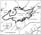
Springs and Holy WellsSite Name: Holy Well (Hole in the wall)Country: England County: Herefordshire Type: Holy Well or Sacred Spring
Nearest Village: Hole in the wall
Map Ref: SO6109028682
Latitude: 51.955255N Longitude: 2.567614W
Condition:
| 5 | Perfect |
| 4 | Almost Perfect |
| 3 | Reasonable but with some damage |
| 2 | Ruined but still recognisable as an ancient site |
| 1 | Pretty much destroyed, possibly visible as crop marks |
| 0 | No data. |
| -1 | Completely destroyed |
| 5 | Superb |
| 4 | Good |
| 3 | Ordinary |
| 2 | Not Good |
| 1 | Awful |
| 0 | No data. |
| 5 | Can be driven to, probably with disabled access |
| 4 | Short walk on a footpath |
| 3 | Requiring a bit more of a walk |
| 2 | A long walk |
| 1 | In the middle of nowhere, a nightmare to find |
| 0 | No data. |
| 5 | co-ordinates taken by GPS or official recorded co-ordinates |
| 4 | co-ordinates scaled from a detailed map |
| 3 | co-ordinates scaled from a bad map |
| 2 | co-ordinates of the nearest village |
| 1 | co-ordinates of the nearest town |
| 0 | no data |
Internal Links:
External Links:
I have visited· I would like to visit
KieKa would like to visit
geoffstickland has visited here
 (PID:37019)")
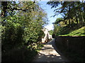
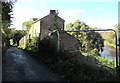
A delightful well which appears to have given the village its name. It flows from an arch in a small copse adorned with ferns and ivy. Like many sites little is recorded regarding its age or properties
You may be viewing yesterday's version of this page. To see the most up to date information please register for a free account.
 (PID:182976)")
Do not use the above information on other web sites or publications without permission of the contributor.
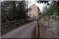
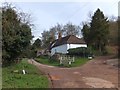
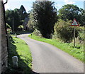
Nearby Images from Geograph Britain and Ireland:
©2019(licence)
©2016(licence)
©2019(licence)
©2013(licence)
©2016(licence)
The above images may not be of the site on this page, they are loaded from Geograph.
Please Submit an Image of this site or go out and take one for us!
Click here to see more info for this site
Nearby sites
Key: Red: member's photo, Blue: 3rd party photo, Yellow: other image, Green: no photo - please go there and take one, Grey: site destroyed
Download sites to:
KML (Google Earth)
GPX (GPS waypoints)
CSV (Garmin/Navman)
CSV (Excel)
To unlock full downloads you need to sign up as a Contributory Member. Otherwise downloads are limited to 50 sites.
Turn off the page maps and other distractions
Nearby sites listing. In the following links * = Image available
4.4km NNE 28° Oldbury Camp (Herefordshire)* Hillfort (SO632326)
4.6km NNW 337° Capler Camp* Hillfort (SO593329)
5.5km WSW 247° Picts Cross Stone (Sellack) Standing Stone (Menhir) (SO560266)
6.4km S 187° Chase Wood Camp* Promontory Fort / Cliff Castle (SO602223)
7.3km NNW 332° Cherry Hill* Hillfort (SO577352)
10.3km WNW 285° Higgin's Well* Holy Well or Sacred Spring (SO51163141)
10.5km NNW 346° Backbury* Hillfort (SO587389)
11.0km WNW 295° St Ann's Well (Aconbury)* Holy Well or Sacred Spring (SO51173338)
11.0km SW 226° St Deinst (Llangarron)* Early Christian Sculptured Stone (SO531211)
11.0km NW 304° Holy Well (Dinedor)* Holy Well or Sacred Spring (SO52013501)
11.2km SE 131° May Hill* Misc. Earthwork (SO69542128)
11.5km WNW 292° Aconbury Hill* Hillfort (SO504331)
11.6km ESE 103° St Mary's Church (Newent) Ancient Cross (SO724260)
11.6km SSW 205° The Queen Stone* Standing Stone (Menhir) (SO561182)
11.6km NW 311° Dinedor Camp* Hillfort (SO524364)
11.9km N 356° St Edith's Well (Herefordshire)* Holy Well or Sacred Spring (SO604406)
12.2km NW 312° Rotherwas Ribbon* Ancient Trackway (SO52053690)
12.2km NE 40° Redhill Wood Hillfort* Hillfort (SO690380)
12.3km ENE 65° Haffield Camp* Hillfort (SO72303390)
12.4km WSW 248° St Weonard's Burial Mound Artificial Mound (SO495242)
12.5km NE 40° Wall Hills Camp* Hillfort (SO692382)
12.9km SSW 202° Huntsham Hill Rockshelters Cave or Rock Shelter (SO561168)
13.7km SSW 201° Symonds Yat East Rockshelter Cave or Rock Shelter (SO56001600)
13.7km SSW 197° Coldwell Rocks Cave or Rock Shelter (SO570156)
13.8km SSW 200° Symonds Yat Fort* Hillfort (SO563157)
View more nearby sites and additional images


 We would like to know more about this location. Please feel free to add a brief description and any relevant information in your own language.
 Wir möchten mehr über diese Stätte erfahren. Bitte zögern Sie nicht, eine kurze Beschreibung und relevante Informationen in Deutsch hinzuzufügen.
 Nous aimerions en savoir encore un peu sur les lieux. S'il vous plaît n'hesitez pas à ajouter une courte description et tous les renseignements pertinents dans votre propre langue.
 Quisieramos informarnos un poco más de las lugares. No dude en añadir una breve descripción y otros datos relevantes en su propio idioma.