<< Our Photo Pages >> Parkfields Park Stone Circle - Modern Stone Circle etc in England in Cheshire
Submitted by TimPrevett on Tuesday, 11 February 2020 Page Views: 6394
Modern SitesSite Name: Parkfields Park Stone Circle Alternative Name: Parkfields Local Theme ParkCountry: England
NOTE: This site is 0.595 km away from the location you searched for.
County: Cheshire Type: Modern Stone Circle etc
Nearest Town: Warrington Nearest Village: Fearnhead
Map Ref: SJ63119099
Latitude: 53.414418N Longitude: 2.556472W
Condition:
| 5 | Perfect |
| 4 | Almost Perfect |
| 3 | Reasonable but with some damage |
| 2 | Ruined but still recognisable as an ancient site |
| 1 | Pretty much destroyed, possibly visible as crop marks |
| 0 | No data. |
| -1 | Completely destroyed |
| 5 | Superb |
| 4 | Good |
| 3 | Ordinary |
| 2 | Not Good |
| 1 | Awful |
| 0 | No data. |
| 5 | Can be driven to, probably with disabled access |
| 4 | Short walk on a footpath |
| 3 | Requiring a bit more of a walk |
| 2 | A long walk |
| 1 | In the middle of nowhere, a nightmare to find |
| 0 | No data. |
| 5 | co-ordinates taken by GPS or official recorded co-ordinates |
| 4 | co-ordinates scaled from a detailed map |
| 3 | co-ordinates scaled from a bad map |
| 2 | co-ordinates of the nearest village |
| 1 | co-ordinates of the nearest town |
| 0 | no data |
Internal Links:
External Links:
I have visited· I would like to visit
jimstone would like to visit
Less than 1 km west of the M6 is this very impressively set out and designed modern stone circle spread across an urban park in the middle of a housing estate. Originally set out in 1984 by Catterall Landscaping for the then Warrington and Runcorn New Town Development Corporation, it has had a prolonged period of neglect, and had become overgrown. Works commenced in 2019 to restore the park and its features, which are set to be completed in early 2020.
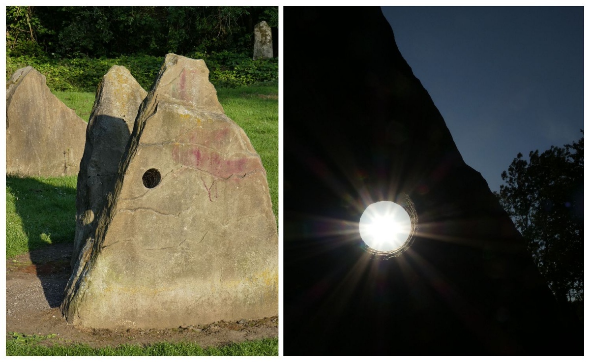
The central feature is a stone circle about 40 metres across, with a ring of individual and paired stones. Each of the four pairs of stones is in alignment to other megaliths radiating out across the park. There is an interior henge ditch, with a further concentric tight ring of seven stones, and a central mirrored pair of stones each with an angled bored aperture. The western side has four individual stones, the eastern side seven individual stones, almost all completely obscured by overgrowth at the time of writing.
The central path is across the axis of the circle (north-north-east / south-south-west); research using extrapolated data from Solstice Streets shows that the circle and its outliers are not quite in alignment with Solstice solar events, but one assumes that the circle's alignments suggest a reference to the solar calendar key points. A leaflet from the early 80s suggests this is more to with a reference to ley lines.
A pair of stones from the main ring point north-north-west along a path framed by an avenue of trees, nine on the west side, seven on the east side with spaces indicating missing originals. It enters a tree-ringed subtle circular earthwork (originally a turf maze / labyrinth), currently with eight trees on the east, six on the west - spaces for a further two, assumed perished.
Then, via two steps down, and then seven stepping stones across into another circular earthwork defined by what seems intended as a water-course boundary (overgrown and muddied at the time of this visit). Originally the last of these stepping stones was met by the wrist of a huge giant's hand outline laid out inside the cirlce. A semi circle of yew hedges line the northern arc either side of a wooden lattice bridge. Each quarter of this circle has five trees outside, though the north east has six, one appears as more recent growth. This featre then terminates at a large megalith, its broader side facing the circle about 115 metres away.
Between the northern lines of the circle there is the long barrow, next to Stirrup Close. A further very subtle circular earthwork is on the south-south-west side which the 1980s leaflet refers to as a bonfire area, originally with a ring of large blocks at intervals. The interior was lower the the surrounds, covered in gravel - not overgrown with grass, and defined by a ring of bricks set in the ground, which are still visible.
The alignment passes through another former circular earthwork for a maypole. Its socket still visible. A currently concrete ring to the west is the site of a former playground, aligned on what is described as a leyline. The north east side of the former playground has a subtle semi circular linear earthwork, bisected by a path, the northernmost with one of the outlying standing stones adjacent.
Clearly this modern megalithic landscape could be something to be really proud of with more regular TLC, themed talks and events in and around the park. It is very encouraging to see this good, potentially marvellous park being restored and taken care of. Hopefully its care and maintenance is sustained. Condition and ambience ratings based on the current direction of the care of the park. Comment on local social media and paper articles in the past year before works got underway have been less positive.
Surfaced paths wind through the park, but the ground was very boggy in places; had it not been for the frosty morning it would have been quite a quagmire in places.
Access via very considerate parking on nearby roads which all link to paths into the park - Stirrup Close, Parkfields Lane and Kings Road all join to Parkfields.
Friends of Parkfields Park and Fearnhead Community Association have further details of ongoing local activities to promote the upkeep and enjoyment of the park, with further pictures and details of the history, work and community. Acknowledgement to those pages for some of the information reproduced here.
Original text copyright Tim Prevett, 7th February 2020, updated 16th February.
You may be viewing yesterday's version of this page. To see the most up to date information please register for a free account.


These are just the first 25 photos of Parkfields Park Stone Circle. If you log in with a free user account you will be able to see our entire collection.
Do not use the above information on other web sites or publications without permission of the contributor.
Click here to see more info for this site
Nearby sites
Key: Red: member's photo, Blue: 3rd party photo, Yellow: other image, Green: no photo - please go there and take one, Grey: site destroyed
Download sites to:
KML (Google Earth)
GPX (GPS waypoints)
CSV (Garmin/Navman)
CSV (Excel)
To unlock full downloads you need to sign up as a Contributory Member. Otherwise downloads are limited to 50 sites.
Turn off the page maps and other distractions
Nearby sites listing. In the following links * = Image available
1.3km E 85° The Birchwood Monolith* Modern Stone Circle etc (SJ64409110)
2.8km NW 321° Highfield Lane* Round Barrow(s) (SJ61379320)
2.9km SSW 209° St Elphin's Well (Warrington) Holy Well or Sacred Spring (SJ61698847)
3.3km WNW 304° St Oswald (Winwick)* Ancient Cross (SJ6037592833)
3.9km NW 322° St Oswald's Well (Winwick)* Holy Well or Sacred Spring (SJ6074294099)
4.0km NNW 342° Lowton Barrow* Round Barrow(s) (SJ619948)
4.7km NNE 22° Kinknall Stone Natural Stone / Erratic / Other Natural Feature (SJ649953)
5.3km NW 316° The Bloody Stone* Marker Stone (SJ59469488)
6.2km NW 325° Castle Hill (Newton Le Willows)* Round Barrow(s) (SJ59609617)
6.5km ENE 67° Great Woolden Hall Farm* Hillfort (SJ691935)
6.9km ENE 74° Great Woolden Hall Ancient Village or Settlement (SJ698929)
7.7km NNW 329° Lady Hill* Round Barrow(s) (SJ5916497670)
8.6km WNW 300° Windmill Hill (Earlestown)* Round Barrow(s) (SJ55639531)
9.8km SE 143° Legh Oaks Farm Ancient Village or Settlement (SJ690832)
10.9km ESE 114° Fairy Brow Round Barrow(s) (SJ73088654)
10.9km ESE 117° Arthill Heath Farm Ancient Village or Settlement (SJ728859)
11.8km S 186° Whitley Village Round Barrow(s) (SJ617793)
11.8km WSW 254° St Luke's Church (Farnworth) Ancient Cross (SJ5171287749)
12.5km SE 132° Bucklow Hill* Round Barrow(s) (SJ7235582567)
13.1km W 271° St Anne's Well (St Helens)* Holy Well or Sacred Spring (SJ49969143)
13.3km ESE 123° Rostherne Celtic Head* Sculptured Stone (SJ743837)
13.4km NE 41° Boothstown Round Barrow(s) (SD720010)
13.5km SSE 166° Robin Hoods Butts Round Barrow(s) (SJ662778)
15.7km SE 127° Tatton Iron Age roundhouse and pit* Ancient Village or Settlement (SJ757815)
15.7km SE 128° Tatton Neolithic hearth* Ancient Village or Settlement (SJ754811)
View more nearby sites and additional images


 We would like to know more about this location. Please feel free to add a brief description and any relevant information in your own language.
 Wir möchten mehr über diese Stätte erfahren. Bitte zögern Sie nicht, eine kurze Beschreibung und relevante Informationen in Deutsch hinzuzufügen.
 Nous aimerions en savoir encore un peu sur les lieux. S'il vous plaît n'hesitez pas à ajouter une courte description et tous les renseignements pertinents dans votre propre langue.
 Quisieramos informarnos un poco más de las lugares. No dude en añadir una breve descripción y otros datos relevantes en su propio idioma.