<< Our Photo Pages >> The Speech Stone - Marker Stone in England in Gloucestershire
Submitted by 4clydesdale7 on Tuesday, 15 May 2012 Page Views: 3781
Multi-periodSite Name: The Speech StoneCountry: England
NOTE: This site is 2.027 km away from the location you searched for.
County: Gloucestershire Type: Marker Stone
Nearest Town: Cinderford Nearest Village: Speech House
Map Ref: SO62011212
Latitude: 51.806419N Longitude: 2.552398W
Condition:
| 5 | Perfect |
| 4 | Almost Perfect |
| 3 | Reasonable but with some damage |
| 2 | Ruined but still recognisable as an ancient site |
| 1 | Pretty much destroyed, possibly visible as crop marks |
| 0 | No data. |
| -1 | Completely destroyed |
| 5 | Superb |
| 4 | Good |
| 3 | Ordinary |
| 2 | Not Good |
| 1 | Awful |
| 0 | No data. |
| 5 | Can be driven to, probably with disabled access |
| 4 | Short walk on a footpath |
| 3 | Requiring a bit more of a walk |
| 2 | A long walk |
| 1 | In the middle of nowhere, a nightmare to find |
| 0 | No data. |
| 5 | co-ordinates taken by GPS or official recorded co-ordinates |
| 4 | co-ordinates scaled from a detailed map |
| 3 | co-ordinates scaled from a bad map |
| 2 | co-ordinates of the nearest village |
| 1 | co-ordinates of the nearest town |
| 0 | no data |
Internal Links:
External Links:
I have visited· I would like to visit
4clydesdale7 visited on 14th May 2012 - their rating: Cond: 4 Amb: 4 Access: 5 Interesting - this lies on a Watkins Leyline
")
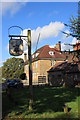
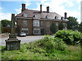
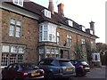
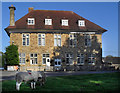
Alfred Watkins of 'leyline fame' suggested this stone lay on a leyline ending at the Hermitage near Courtfield at Lower Lydbrook; the Speech House was the Courthouse for the Verderers of the Forest of Dean in the 17th century but now is a prosperous hotel
Pastscape website: Gloucestershire; Forest of Dean; West Dean; Monument 111820
You may be viewing yesterday's version of this page. To see the most up to date information please register for a free account.
Do not use the above information on other web sites or publications without permission of the contributor.
Nearby Images from Geograph Britain and Ireland:
©2013(licence)
©2012(licence)
©2012(licence)
©2019(licence)
©2012(licence)
The above images may not be of the site on this page, they are loaded from Geograph.
Please Submit an Image of this site or go out and take one for us!
Click here to see more info for this site
Nearby sites
Key: Red: member's photo, Blue: 3rd party photo, Yellow: other image, Green: no photo - please go there and take one, Grey: site destroyed
Download sites to:
KML (Google Earth)
GPX (GPS waypoints)
CSV (Garmin/Navman)
CSV (Excel)
To unlock full downloads you need to sign up as a Contributory Member. Otherwise downloads are limited to 50 sites.
Turn off the page maps and other distractions
Nearby sites listing. In the following links * = Image available
4.4km ESE 110° Soudley Camp* Promontory Fort / Cliff Castle (SO66161058)
4.4km SE 125° Patten Stone Marker Stone (SO65640959)
4.6km ESE 109° Dean Heritage Centre* Museum (SO664106)
4.7km SE 132° Drummer Boys Grave Stone* Ancient Mine, Quarry or other Industry (SO65470898)
5.3km SW 227° Gattle's Cross* Marker Stone (SO5812608512)
5.6km ENE 70° Littledean Standing Stone* Marker Stone (SO6731713967)
5.8km SW 227° Clearwell Caves* Ancient Mine, Quarry or other Industry (SO57700822)
6.1km W 269° Long Stone, Staunton* Standing Stone (Menhir) (SO55931206)
6.1km NW 304° Coldwell Rocks Cave or Rock Shelter (SO570156)
6.2km NE 54° St Anthony's Well (Cinderford)* Holy Well or Sacred Spring (SO67051574)
6.6km ENE 60° Welshbury Hill Ancient Village or Settlement (SO678154)
6.7km ENE 59° Welshbury Camp* Hillfort (SO67751555)
6.7km WNW 302° Symonds Yat Fort* Hillfort (SO563157)
6.7km ENE 59° Welshbury Cairn* Cairn (SO67831555)
6.8km WNW 299° Bowler's Hole Cave or Rock Shelter (SO56101545)
6.8km WNW 300° Symonds Yat Cave Cave or Rock Shelter (SO56101555)
6.8km WNW 300° Symonds Yat Cave 3 Cave or Rock Shelter (SO56101555)
6.8km WNW 300° Symonds Yat Cave 2 Cave or Rock Shelter (SO56101555)
6.8km WNW 300° Wye Rapids Cave Cave or Rock Shelter (SO56101555)
6.9km W 273° Staunton Cross* Ancient Cross (SO5506412571)
7.0km WNW 286° Whipping Brook Cave Cave or Rock Shelter (SO55251410)
7.1km WNW 294° Lord's Wood Cave Cave or Rock Shelter (SO55551503)
7.1km WNW 302° Symonds Yat East Rockshelter Cave or Rock Shelter (SO56001600)
7.1km WNW 296° Merlin's Cave (Herefordshire) Cave or Rock Shelter (SO556153)
7.2km WNW 298° Symonds Yat West Cave or Rock Shelter (SO55701555)
View more nearby sites and additional images


 We would like to know more about this location. Please feel free to add a brief description and any relevant information in your own language.
 Wir möchten mehr über diese Stätte erfahren. Bitte zögern Sie nicht, eine kurze Beschreibung und relevante Informationen in Deutsch hinzuzufügen.
 Nous aimerions en savoir encore un peu sur les lieux. S'il vous plaît n'hesitez pas à ajouter une courte description et tous les renseignements pertinents dans votre propre langue.
 Quisieramos informarnos un poco más de las lugares. No dude en añadir una breve descripción y otros datos relevantes en su propio idioma.