<< Text Pages >> Kinknall Stone - Natural Stone / Erratic / Other Natural Feature in England in Cheshire
Submitted by Anonymous on Wednesday, 28 September 2005 Page Views: 7265
Natural PlacesSite Name: Kinknall Stone Alternative Name: King's StoneCountry: England
NOTE: This site is 0.652 km away from the location you searched for.
County: Cheshire Type: Natural Stone / Erratic / Other Natural Feature
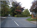
Nearest Town: Warrington Nearest Village: Culcheth
Map Ref: SJ649953
Latitude: 53.453279N Longitude: 2.530025W
Condition:
| 5 | Perfect |
| 4 | Almost Perfect |
| 3 | Reasonable but with some damage |
| 2 | Ruined but still recognisable as an ancient site |
| 1 | Pretty much destroyed, possibly visible as crop marks |
| 0 | No data. |
| -1 | Completely destroyed |
| 5 | Superb |
| 4 | Good |
| 3 | Ordinary |
| 2 | Not Good |
| 1 | Awful |
| 0 | No data. |
| 5 | Can be driven to, probably with disabled access |
| 4 | Short walk on a footpath |
| 3 | Requiring a bit more of a walk |
| 2 | A long walk |
| 1 | In the middle of nowhere, a nightmare to find |
| 0 | No data. |
| 5 | co-ordinates taken by GPS or official recorded co-ordinates |
| 4 | co-ordinates scaled from a detailed map |
| 3 | co-ordinates scaled from a bad map |
| 2 | co-ordinates of the nearest village |
| 1 | co-ordinates of the nearest town |
| 0 | no data |
Internal Links:
External Links:
Natural Stone / Glacial Erratic in Cheshire
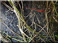
Glacial erratic, about 1 metre high, standing in the private garden of New Kinknall, at the junction of Hob Hey Lane and Clifton Drive, Culcheth.
A comment in William Beamont's "The Fee of Makerfield, with an account of some of its lords, the Barons of Newton" (1872) may have some relation to this site:
"Culcheth ... puts in a claim to be that Celchyth in Northumbria, where the three councils of 786, 801, and 816 were held ... King Offa presided at the first two councils. Jaenbert was archbishop at the first, Ethelhard at the second, and Wulfrid at the third. (See Thorpe's Diplomatar. Anglic., 38, 45, and 72.)
"Archbishop Parker was of opinion that these councils were held in Northumbria, and both Sir Peter Leycester, a very careful investigator of our local antiquities, and Dr. Hook, think that Culcheth in Winwick was their place of meeting. (See P. Leycester's Hist. Chesh., i, 134, and Hook's Lives of the Archbishops, i, 250 n., 265, 279.) If Kenyon, which adjoins Culcheth, really means, as it is said, the place of tents, and Kinknall-within-Culcheth, means the king's dwelling, both may be memorials of these councils. (Whitaker's Hist. of Manchester.)"
"Old Kingnall Hall" and a moated site are shown on the 1849 25in. OS map about a hundred yards west of the stone, which is not itself marked.
You may be viewing yesterday's version of this page. To see the most up to date information please register for a free account.
Do not use the above information on other web sites or publications without permission of the contributor.
Nearby Images from Geograph Britain and Ireland:
©2015(licence)
©2011(licence)
©2016(licence)
©2012(licence)
©2009(licence)
The above images may not be of the site on this page, they are loaded from Geograph.
Please Submit an Image of this site or go out and take one for us!
Click here to see more info for this site
Nearby sites
Key: Red: member's photo, Blue: 3rd party photo, Yellow: other image, Green: no photo - please go there and take one, Grey: site destroyed
Download sites to:
KML (Google Earth)
GPX (GPS waypoints)
CSV (Garmin/Navman)
CSV (Excel)
To unlock full downloads you need to sign up as a Contributory Member. Otherwise downloads are limited to 50 sites.
Turn off the page maps and other distractions
Nearby sites listing. In the following links * = Image available
3.0km W 260° Lowton Barrow* Round Barrow(s) (SJ619948)
4.1km WSW 239° Highfield Lane* Round Barrow(s) (SJ61379320)
4.2km S 186° The Birchwood Monolith* Modern Stone Circle etc (SJ64409110)
4.3km WSW 253° St Oswald's Well (Winwick)* Holy Well or Sacred Spring (SJ6074294099)
4.6km ESE 113° Great Woolden Hall Farm* Hillfort (SJ691935)
4.7km SSW 202° Parkfields Park Stone Circle* Modern Stone Circle etc (SJ63119099)
5.1km WSW 241° St Oswald (Winwick)* Ancient Cross (SJ6037592833)
5.4km W 279° Castle Hill (Newton Le Willows)* Round Barrow(s) (SJ59609617)
5.4km W 265° The Bloody Stone* Marker Stone (SJ59469488)
5.4km ESE 116° Great Woolden Hall Ancient Village or Settlement (SJ698929)
6.2km WNW 292° Lady Hill* Round Barrow(s) (SJ5916497670)
7.5km SSW 205° St Elphin's Well (Warrington) Holy Well or Sacred Spring (SJ61698847)
9.1km NE 51° Boothstown Round Barrow(s) (SD720010)
9.2km W 270° Windmill Hill (Earlestown)* Round Barrow(s) (SJ55639531)
12.0km SE 137° Fairy Brow Round Barrow(s) (SJ73088654)
12.3km SE 140° Arthill Heath Farm Ancient Village or Settlement (SJ728859)
12.7km NNW 329° Mabs Cross* Ancient Cross (SD5852706268)
12.8km SSE 161° Legh Oaks Farm Ancient Village or Settlement (SJ690832)
13.4km ENE 75° St Mary the Virgin (Eccles) Ancient Cross (SJ77899868)
14.7km SSE 149° Bucklow Hill* Round Barrow(s) (SJ7235582567)
14.9km SE 141° Rostherne Celtic Head* Sculptured Stone (SJ743837)
15.2km WSW 240° St Luke's Church (Farnworth) Ancient Cross (SJ5171287749)
15.2km NNE 25° Bolton Museum* Museum (SD715090)
15.4km WSW 255° St Anne's Well (St Helens)* Holy Well or Sacred Spring (SJ49969143)
15.5km E 89° The Great Stone (Trafford)* Natural Stone / Erratic / Other Natural Feature (SJ8043395580)
View more nearby sites and additional images


 We would like to know more about this location. Please feel free to add a brief description and any relevant information in your own language.
 Wir möchten mehr über diese Stätte erfahren. Bitte zögern Sie nicht, eine kurze Beschreibung und relevante Informationen in Deutsch hinzuzufügen.
 Nous aimerions en savoir encore un peu sur les lieux. S'il vous plaît n'hesitez pas à ajouter une courte description et tous les renseignements pertinents dans votre propre langue.
 Quisieramos informarnos un poco más de las lugares. No dude en añadir una breve descripción y otros datos relevantes en su propio idioma.