

, Aubrey Burl")
<< Our Photo Pages >> King Arthur's Well (Walltown Gap) - Holy Well or Sacred Spring in England in Northumberland
Submitted by Anne T on Friday, 12 July 2019 Page Views: 2693
Springs and Holy WellsSite Name: King Arthur's Well (Walltown Gap) Alternative Name: King Arthur's Well (Hadrian's Wall); King's Well (Walltown Crags)Country: England County: Northumberland Type: Holy Well or Sacred Spring
Nearest Town: Haltwhistle Nearest Village: Greenhead
Map Ref: NY68066664
Latitude: 54.993311N Longitude: 2.500745W
Condition:
| 5 | Perfect |
| 4 | Almost Perfect |
| 3 | Reasonable but with some damage |
| 2 | Ruined but still recognisable as an ancient site |
| 1 | Pretty much destroyed, possibly visible as crop marks |
| 0 | No data. |
| -1 | Completely destroyed |
| 5 | Superb |
| 4 | Good |
| 3 | Ordinary |
| 2 | Not Good |
| 1 | Awful |
| 0 | No data. |
| 5 | Can be driven to, probably with disabled access |
| 4 | Short walk on a footpath |
| 3 | Requiring a bit more of a walk |
| 2 | A long walk |
| 1 | In the middle of nowhere, a nightmare to find |
| 0 | No data. |
| 5 | co-ordinates taken by GPS or official recorded co-ordinates |
| 4 | co-ordinates scaled from a detailed map |
| 3 | co-ordinates scaled from a bad map |
| 2 | co-ordinates of the nearest village |
| 1 | co-ordinates of the nearest town |
| 0 | no data |
Internal Links:
External Links:
I have visited· I would like to visit
Anne T visited on 8th Jul 2019 - their rating: Cond: 1 Amb: 4 Access: 4 King Arthur's Well, Walltown Crags: Whilst this well may now be destroyed or lost, the scenery here is fantastic, and it was well worth coming out to look.
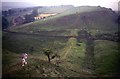
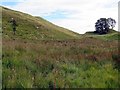
We were unable to find this holy well, despite having the GPS to guide us to the spot. However, we did see signs of reeds and tall grasses where the water might have pooled and flowed.
On the way up to the nick in the crags where the well is located, there is water emerging from the hillside at NY 68041 66551, which runs in a small stream down the slope, feeding two drinking troughs in the field below. We did visit after a period of prolonged dry weather, so wondered if the water emerges from higher up the hill after wet weather.
 (PID:199804)")
This holy well is marked on the OS maps of the area, and is recorded as Pastscape Monument No. 13922. In 1946 the well was "surrounded by masonry". By 1966, the entry had been updated to say: "the well is now covered with a cast iron lid set in concrete", and this was confirmed again in 1989.
J. Collingwood Bruce in his 1863 book "The Roman Wall" (page 155, 10th reprint 1947) says: "Close behind the Wall in the middle of the gap is a spring, surrounded by masonry, now much disordered, called the King's Well; the inhabitants name it King Arthur's Well. Other accounts are given of it. Hutchinson (History of Northumberland, volume 1, page 44) says: 'Travellers are shown a well among the cliffs, where it is said Paulinus baptized King Egbert; but it is more probably it was Edwin, King of Northumberland'. But Edwin was christened at York, and this story at least is untrue. The true story of the well, like its water, is now lost". (If the water was lost in Collingwood Bruce's time in 1863, I'm left wondering why the need for the cast iron cover - can anyone help??)
We went armed with our GPS and the modern OS map but could not find a cast iron well cover, only an area of reeds and taller, lusher grass, which expanded into an area that was only marginally boggy after a prolonged period of dry weather. We did find a spring emerging downslope at NY 68041 66551, which fed drinking troughs in the fields below.
In 2003, erosion caused by the feet of many walkers on the Hadrian's Wall path, necessitated an upgrade to the footpath, and an excavation took place. Photographs of these excavations at/around the well area can be found at Looking Down on King Arthur's Well 1 and Looking Down on King Arthur's Well 2. Photographs by Oliver Dixon and licensed for re-use under a Creative Commons. Oliver Dixon says: "The opportunity has been taken following the disturbance caused by path construction at this point to excavate the site. What has been found is evidence of a hitherto unknown Roman building - definitely pre-Arthurian and definitely not a well".
You may be viewing yesterday's version of this page. To see the most up to date information please register for a free account.
 (PID:199805)")
 (PID:199803)")
 (PID:199802)")
Do not use the above information on other web sites or publications without permission of the contributor.
Nearby Images from Geograph Britain and Ireland:
©2017(licence)
©2015(licence)
©2024(licence)
©2008(licence)

©2014(licence)
The above images may not be of the site on this page, they are loaded from Geograph.
Please Submit an Image of this site or go out and take one for us!
Click here to see more info for this site
Nearby sites
Key: Red: member's photo, Blue: 3rd party photo, Yellow: other image, Green: no photo - please go there and take one, Grey: site destroyed
Download sites to:
KML (Google Earth)
GPX (GPS waypoints)
CSV (Garmin/Navman)
CSV (Excel)
To unlock full downloads you need to sign up as a Contributory Member. Otherwise downloads are limited to 50 sites.
Turn off the page maps and other distractions
Nearby sites listing. In the following links * = Image available
101m NE 50° Hadrian's Wall (Turret 44b)* Misc. Earthwork (NY6813866704)
2.1km E 93° Aesica Vallum Round Barrow* Round Barrow(s) (NY70196650)
2.3km E 86° Aescia Roman Fort* Stone Fort or Dun (NY7036566800)
3.6km E 89° Cawfield Roman Fort Stone Fort or Dun (NY71666667)
4.0km ENE 64° Ventner's Hall Cairn (1)* Cairn (NY71696841)
4.3km ENE 65° Ventner's Hall Cairn (2)* Cairn (NY7198068434)
4.5km E 94° Mare and Foal* Standing Stones (NY72536633)
4.7km WNW 284° Gilsland Spa Well* Holy Well or Sacred Spring (NY6354067815)
4.7km W 264° Hadrian's Wall (Poltross Burn)* Stone Fort or Dun (NY6340166198)
4.7km WNW 283° Gilsland Spa Sulphur Spring Holy Well or Sacred Spring (NY63476776)
4.7km WNW 288° Popping Stone* Natural Stone / Erratic / Other Natural Feature (NY63556815)
4.9km SSE 155° Broomhouse (Haltwhistle)* Ancient Village or Settlement (NY70126222)
6.4km NNW 327° Standingstone Rigg Standing Stone (Cumbria) Standing Stone (Menhir) (NY6458271969)
6.8km SW 218° Hartleyburn Common 1c Rock Art (NY6387161326)
6.8km SW 218° Hartleyburn Common 1d Rock Art (NY6387361324)
6.8km SW 218° Hartleyburn Common 1a* Rock Art (NY6387261311)
6.8km SW 218° Hartleyburn Common 1b Rock Art (NY6384861302)
6.9km SW 218° Hartleyburn Common 1e* Rock Art (NY6377261261)
6.9km SW 218° The Curricks* Ancient Village or Settlement (NY63746122)
6.9km SW 216° Hartleyburn Common 5* Rock Art (NY6396961024)
7.0km SW 218° Hartleyburn Common 2 Rock Art (NY6370061200)
7.2km E 88° The Sill* Museum (NY7527566896)
7.2km SSW 213° Hartleyburn Common 3* Rock Art (NY6412160581)
7.3km SSW 211° Haining House (Lambley)* Cairn (NY64296042)
7.4km SSW 213° Hartleyburn Common 4 Rock Art (NY6398460470)
View more nearby sites and additional images


 We would like to know more about this location. Please feel free to add a brief description and any relevant information in your own language.
 Wir möchten mehr über diese Stätte erfahren. Bitte zögern Sie nicht, eine kurze Beschreibung und relevante Informationen in Deutsch hinzuzufügen.
 Nous aimerions en savoir encore un peu sur les lieux. S'il vous plaît n'hesitez pas à ajouter une courte description et tous les renseignements pertinents dans votre propre langue.
 Quisieramos informarnos un poco más de las lugares. No dude en añadir una breve descripción y otros datos relevantes en su propio idioma.