<< Our Photo Pages >> Grove Road - Stone Circle in England in Dorset
Submitted by TimPrevett on Wednesday, 20 April 2005 Page Views: 10251
Neolithic and Bronze AgeSite Name: Grove RoadCountry: England
NOTE: This site is 1.417 km away from the location you searched for.
County: Dorset Type: Stone Circle
Nearest Town: Easton
Map Ref: SY703723
Latitude: 50.549701N Longitude: 2.420563W
Condition:
| 5 | Perfect |
| 4 | Almost Perfect |
| 3 | Reasonable but with some damage |
| 2 | Ruined but still recognisable as an ancient site |
| 1 | Pretty much destroyed, possibly visible as crop marks |
| 0 | No data. |
| -1 | Completely destroyed |
| 5 | Superb |
| 4 | Good |
| 3 | Ordinary |
| 2 | Not Good |
| 1 | Awful |
| 0 | No data. |
| 5 | Can be driven to, probably with disabled access |
| 4 | Short walk on a footpath |
| 3 | Requiring a bit more of a walk |
| 2 | A long walk |
| 1 | In the middle of nowhere, a nightmare to find |
| 0 | No data. |
| 5 | co-ordinates taken by GPS or official recorded co-ordinates |
| 4 | co-ordinates scaled from a detailed map |
| 3 | co-ordinates scaled from a bad map |
| 2 | co-ordinates of the nearest village |
| 1 | co-ordinates of the nearest town |
| 0 | no data |
Internal Links:
External Links:
I have visited· I would like to visit
Ogham visited on 8th Mar 2003 - their rating: Cond: 1 Amb: 1 Access: 5
Phillwhite visited on 5th Mar 1986 - their rating: Cond: -1 Local knowledge indicates there were musltipul circle years ago.
TimPrevett have visited here
Average ratings for this site from all visit loggers: Condition: 0
")
These claims come from Susann Palmer who has spent 30 years plus investigating prehistoric Portland, and a knowledgeable local man, so we thought it might be worth a look.
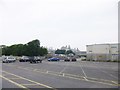
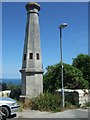
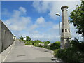
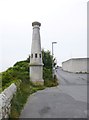
We took a look for something of the possible hengiform earthwork, but were unable to interpret any subtle clues; however the stones were easier to find. They are at the end of Grove Rd, next to the prison We were told they were once in the Governer's Garden, but being a 'Pagan Monument', were removed by prisoners under the instruction of the Governer, to form part of the wall above the cliff face.
The limestone is extremely gnarled and well weathered, and as described to us, unlike anything else on the Isle. Reminiscent of the appearance of the stones at the Rollrights or Arbor Low. There would have been a good number of stones, too, assuming most have not been broken up. The stones are along a large section of the road boundary, with other material having been built on top of, and around them.
If you ever go for a look in person, the security at the prison may take an interest in your activity. We had 4 cars pull up in our group, and spent 20 minutes looking at, discussing and photographing the stones. During this time we became aware of CCTV trained on us and security taking down registration numbers!
This remains an uncertain claim, but documented to give further opportunity to investigate it.
Susann Palmer said these sites would be included in her forthcoming book, "Portland Inventory of Archaeology, Sites & Finds", coming out in June-ish 2005.
Note: The possible remains of stone circle on Portland, Dorset tracked down by Tim and the rest of the Megalithic Meets team. What do you think?
You may be viewing yesterday's version of this page. To see the most up to date information please register for a free account.
")
")
Do not use the above information on other web sites or publications without permission of the contributor.
Andy B has found this location on Google Street View:
Nearby Images from Geograph Britain and Ireland:
©2014(licence)
©2010(licence)
©2021(licence)
©2014(licence)

©2017(licence)
The above images may not be of the site on this page, they are loaded from Geograph.
Please Submit an Image of this site or go out and take one for us!
Click here to see more info for this site
Nearby sites
Key: Red: member's photo, Blue: 3rd party photo, Yellow: other image, Green: no photo - please go there and take one, Grey: site destroyed
Download sites to:
KML (Google Earth)
GPX (GPS waypoints)
CSV (Garmin/Navman)
CSV (Excel)
To unlock full downloads you need to sign up as a Contributory Member. Otherwise downloads are limited to 50 sites.
Turn off the page maps and other distractions
Nearby sites listing. In the following links * = Image available
1.3km WNW 290° Kingbarrow Modern Stone Circle etc (SY6907772745)
1.7km WNW 289° Tout Quarry Sculpture Park Stone Circle* Modern Stone Circle etc (SY68747286)
1.8km WNW 287° Tout Quarry Sculpture Park Alignment* Modern Stone Circle etc (SY68577283)
1.9km W 275° Tout Quarry Sculpture Park - The Circle of Stones* Modern Stone Circle etc (SY68397248)
2.1km WNW 289° Jacob's Well (Portland)* Holy Well or Sacred Spring (SY683730)
3.5km SSW 211° Culverwell Mesolithic Site* Ancient Village or Settlement (SY685693)
4.9km SW 215° Pulpit Rock (Portland)* Rock Outcrop (SY675683)
6.4km NNW 334° Dripping Well (Weymouth) Holy Well or Sacred Spring (SY6750478079)
11.2km NNE 24° Southdown (Dorset)* Barrow Cemetery (SY749825)
11.5km N 356° Chalbury* Hillfort (SY695838)
12.0km NE 42° Chaldon Down* Barrow Cemetery (SY783812)
12.0km NNE 20° Poxwell Cairn* Cairn (SY74518357)
12.5km N 353° Bincombe Barrows* Barrow Cemetery (SY689847)
12.5km N 2° Northdown (Dorset)* Barrow Cemetery (SY708848)
12.8km NE 45° Wardstone Barrow* Round Barrow(s) (SY79338133)
13.0km N 359° Broadmayne Bank Barrow* Long Barrow (SY702853)
13.5km N 358° Whitcombe 1* Long Barrow (SY699858)
13.6km NNW 342° Upwey Wishing Well* Holy Well or Sacred Spring (SY661852)
13.6km N 350° Bincombe Down* Barrow Cemetery (SY679857)
13.8km NE 54° Hambury Tout Barrows* Barrow Cemetery (SY81588029)
13.8km NNW 347° Ridgeway Hill* Barrow Cemetery (SY672858)
13.9km N 350° Winterborne Came 18b (Bincombe) Cairn (SY680860)
14.1km NNE 32° Lord's Barrow* Round Barrow(s) (SY778842)
14.1km N 353° Came Down* Barrow Cemetery (SY687863)
14.6km NNW 335° Friar Waddon Hill Barrow Cemetery (SY641855)
View more nearby sites and additional images


 We would like to know more about this location. Please feel free to add a brief description and any relevant information in your own language.
 Wir möchten mehr über diese Stätte erfahren. Bitte zögern Sie nicht, eine kurze Beschreibung und relevante Informationen in Deutsch hinzuzufügen.
 Nous aimerions en savoir encore un peu sur les lieux. S'il vous plaît n'hesitez pas à ajouter une courte description et tous les renseignements pertinents dans votre propre langue.
 Quisieramos informarnos un poco más de las lugares. No dude en añadir una breve descripción y otros datos relevantes en su propio idioma.