<< Our Photo Pages >> Shad Well - Holy Well or Sacred Spring in England in Somerset
Submitted by KiwiBetsy on Friday, 08 September 2006 Page Views: 8226
Springs and Holy WellsSite Name: Shad WellCountry: England
NOTE: This site is 1.062 km away from the location you searched for.
County: Somerset Type: Holy Well or Sacred Spring
Nearest Town: Wincanton
Map Ref: ST711289
Latitude: 51.058706N Longitude: 2.413745W
Condition:
| 5 | Perfect |
| 4 | Almost Perfect |
| 3 | Reasonable but with some damage |
| 2 | Ruined but still recognisable as an ancient site |
| 1 | Pretty much destroyed, possibly visible as crop marks |
| 0 | No data. |
| -1 | Completely destroyed |
| 5 | Superb |
| 4 | Good |
| 3 | Ordinary |
| 2 | Not Good |
| 1 | Awful |
| 0 | No data. |
| 5 | Can be driven to, probably with disabled access |
| 4 | Short walk on a footpath |
| 3 | Requiring a bit more of a walk |
| 2 | A long walk |
| 1 | In the middle of nowhere, a nightmare to find |
| 0 | No data. |
| 5 | co-ordinates taken by GPS or official recorded co-ordinates |
| 4 | co-ordinates scaled from a detailed map |
| 3 | co-ordinates scaled from a bad map |
| 2 | co-ordinates of the nearest village |
| 1 | co-ordinates of the nearest town |
| 0 | no data |
Internal Links:
External Links:
I have visited· I would like to visit
SolarMegalith would like to visit
")
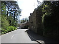
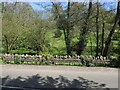
Shad Well sits on the left side (as you travel toward Bruton) of the B3081 on the edge of Wincanton and on the corner of Shadwell Lane, just opposite the River Cale.
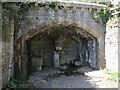
The structure housing the well consists of a two arches with a pillar between upon which is mounted a large iron tap. Under one arch is a stone tub or font and under the other the well drips from underneath a large mound of mosses into a small pool. On the pillar can just be made out a date, possibly 1865.
You may be viewing yesterday's version of this page. To see the most up to date information please register for a free account.
")
")
")
")
Do not use the above information on other web sites or publications without permission of the contributor.
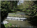
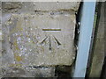
Nearby Images from Geograph Britain and Ireland:
©2024(licence)
©2024(licence)
©2024(licence)
©2024(licence)
©2024(licence)
The above images may not be of the site on this page, they are loaded from Geograph.
Please Submit an Image of this site or go out and take one for us!
Click here to see more info for this site
Nearby sites
Key: Red: member's photo, Blue: 3rd party photo, Yellow: other image, Green: no photo - please go there and take one, Grey: site destroyed
Download sites to:
KML (Google Earth)
GPX (GPS waypoints)
CSV (Garmin/Navman)
CSV (Excel)
To unlock full downloads you need to sign up as a Contributory Member. Otherwise downloads are limited to 50 sites.
Turn off the page maps and other distractions
Nearby sites listing. In the following links * = Image available
451m ESE 119° Wincanton and District Museum* Museum (ST7149528680)
2.0km ESE 120° Physic Well (Wincanton) Holy Well or Sacred Spring (ST728279)
4.7km ESE 108° St Barbara's Well* Holy Well or Sacred Spring
6.5km NNW 336° Patwell* Holy Well or Sacred Spring (ST6843434863)
6.7km ENE 70° Egbert's Stone Standing Stone (Menhir) (ST774312)
6.9km ENE 70° Bourton Monolith* Standing Stone (Menhir) (ST7757731221)
7.8km NE 42° Park Hill Camp* Hillfort (ST76383471)
8.2km NE 37° St. Peter's Pump* Holy Well or Sacred Spring (ST761354)
8.8km WSW 246° King Arthur's Well* Holy Well or Sacred Spring (ST630253)
9.0km WSW 247° Queen Anne's Well, Cadbury Castle* Holy Well or Sacred Spring (ST628254)
9.1km WSW 245° South Cadbury Castle* Hillfort (ST62812515)
9.8km ESE 103° Gillingham Vicarage (Dorset) Ancient Cross (ST80682656)
9.9km SW 230° St Andrew's Well (Corton Denham)* Holy Well or Sacred Spring (ST635225)
10.9km ENE 58° Whitesheet Castle* Hillfort (ST804346)
11.0km NE 55° Whitesheet Hill* Ancient Village or Settlement (ST80163518)
12.4km NNW 341° Evercreech 14-15 Bowl Barrows* Round Barrow(s) (ST67094063)
12.5km NNW 339° Small Down Barrows* Barrow Cemetery (ST666406)
12.6km NNW 339° Small Down Camp* Hillfort (ST666407)
13.0km NNE 13° Witham Friary I Round Barrow(s) (ST74014156)
13.0km ENE 59° Rodmead Barrow Cemetery Barrow Cemetery (ST823356)
13.0km ENE 57° Rodmead Hill Enclosure Ancient Village or Settlement (ST82123593)
13.5km NE 41° Town Well (Maiden Bradley) Holy Well or Sacred Spring (ST8010039028)
13.7km NNE 17° Witham Friary 2 Round Barrow(s) (ST75264194)
14.8km ENE 78° Puckwell* Holy Well or Sacred Spring (ST856319)
14.8km NNW 339° West Cranmore Round Barrows* Barrow Cemetery (ST65844274)
View more nearby sites and additional images


 We would like to know more about this location. Please feel free to add a brief description and any relevant information in your own language.
 Wir möchten mehr über diese Stätte erfahren. Bitte zögern Sie nicht, eine kurze Beschreibung und relevante Informationen in Deutsch hinzuzufügen.
 Nous aimerions en savoir encore un peu sur les lieux. S'il vous plaît n'hesitez pas à ajouter une courte description et tous les renseignements pertinents dans votre propre langue.
 Quisieramos informarnos un poco más de las lugares. No dude en añadir una breve descripción y otros datos relevantes en su propio idioma.