

<< Our Photo Pages >> Lady Godiva's Cross - Ancient Cross in England in West Midlands
Submitted by TimPrevett on Saturday, 19 May 2007 Page Views: 10149
Early Medieval (Dark Age)Site Name: Lady Godiva's Cross Alternative Name: St Bartholomew (Penn), Penn Parish ChurchCountry: England
NOTE: This site is 4.868 km away from the location you searched for.
County: West Midlands Type: Ancient Cross
Nearest Town: Penn
Map Ref: SO89439528
Latitude: 52.555256N Longitude: 2.157331W
Condition:
| 5 | Perfect |
| 4 | Almost Perfect |
| 3 | Reasonable but with some damage |
| 2 | Ruined but still recognisable as an ancient site |
| 1 | Pretty much destroyed, possibly visible as crop marks |
| 0 | No data. |
| -1 | Completely destroyed |
| 5 | Superb |
| 4 | Good |
| 3 | Ordinary |
| 2 | Not Good |
| 1 | Awful |
| 0 | No data. |
| 5 | Can be driven to, probably with disabled access |
| 4 | Short walk on a footpath |
| 3 | Requiring a bit more of a walk |
| 2 | A long walk |
| 1 | In the middle of nowhere, a nightmare to find |
| 0 | No data. |
| 5 | co-ordinates taken by GPS or official recorded co-ordinates |
| 4 | co-ordinates scaled from a detailed map |
| 3 | co-ordinates scaled from a bad map |
| 2 | co-ordinates of the nearest village |
| 1 | co-ordinates of the nearest town |
| 0 | no data |
Internal Links:
External Links:
I have visited· I would like to visit
NatEvans88 visited on 14th Oct 2023 - their rating: Cond: 3 Amb: 4 Access: 4
")
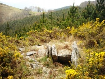
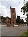
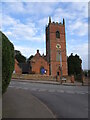
An early mediaeval stepped cross base, linked with Lady Godiva, in the south of the churchyard of St Bartholomew's, Penn. A later mediaeval cross, which was once on top of the earlier mount, is now reconstructed to the west of the church building.
You may be viewing yesterday's version of this page. To see the most up to date information please register for a free account.
")
")
Do not use the above information on other web sites or publications without permission of the contributor.
Nearby Images from Geograph Britain and Ireland:
©2015(licence)
©2015(licence)
©2021(licence)
©2021(licence)
©2021(licence)
The above images may not be of the site on this page, they are loaded from Geograph.
Please Submit an Image of this site or go out and take one for us!
Click here to see more info for this site
Nearby sites
Key: Red: member's photo, Blue: 3rd party photo, Yellow: other image, Green: no photo - please go there and take one, Grey: site destroyed
Download sites to:
KML (Google Earth)
GPX (GPS waypoints)
CSV (Garmin/Navman)
CSV (Excel)
To unlock full downloads you need to sign up as a Contributory Member. Otherwise downloads are limited to 50 sites.
Turn off the page maps and other distractions
Nearby sites listing. In the following links * = Image available
4.0km NNE 30° St Peter (Wolverhampton)* Ancient Cross (SO9141998765)
4.0km NNE 17° West Park (Wolverhampton)* Natural Stone / Erratic / Other Natural Feature (SO90609912)
4.1km NNE 27° The Bargain Stone* Holed Stone (SO913989)
5.4km NNE 17° Wulfruna's Well* Holy Well or Sacred Spring (SJ9102600470)
9.8km NNW 346° The Leper Well* Holy Well or Sacred Spring (SJ87030478)
10.8km W 277° Chesterton Walls* Hillfort (SO78679668)
12.6km NW 317° St Cuthbert's Well (Shropshire)* Holy Well or Sacred Spring (SJ8084404565)
12.9km SSW 205° The Giant's Well (Kinver)* Holy Well or Sacred Spring (SO839836)
13.3km SSW 211° Boltstone* Standing Stone (Menhir) (SO825839)
13.4km SSW 206° Kinver* Promontory Fort / Cliff Castle (SO835832)
13.6km W 272° St Peter's Well (Worfield)* Holy Well or Sacred Spring (SO758958)
13.6km ESE 107° St Augustine's Well (Sandwell)* Holy Well or Sacred Spring (SP0248391296)
13.7km S 169° Wychbury Camp* Hillfort (SO920818)
13.8km WSW 251° Burf Castle Hillfort (SO76279085)
14.0km NE 41° The Great Stones of Landywood* Stone Circle (SJ9872805826)
15.4km SSE 161° St Kenelm's Well* Holy Well or Sacred Spring (SO9444280755)
15.5km SSE 165° The Four Stones* Modern Stone Circle etc (SO9337180328)
15.5km WSW 243° Quatt Cross* Ancient Cross (SO7562988192)
15.9km S 180° Stakenbridge Lane* Round Barrow(s) (SO894794)
16.1km SSW 206° Drakelow Hillfort Hillfort (SO8219780879)
17.1km SW 236° Hampton Loade Cross* Ancient Cross (SO75258574)
17.2km SW 231° Alveley Cross* Ancient Cross (SO7595584525)
18.0km ESE 115° War Stone* Natural Stone / Erratic / Other Natural Feature (SP058877)
18.5km E 89° The King's Standing* Round Barrow(s) (SP080956)
18.8km SW 220° Upper Arley stone* Standing Stone (Menhir) (SO773809)
View more nearby sites and additional images


 We would like to know more about this location. Please feel free to add a brief description and any relevant information in your own language.
 Wir möchten mehr über diese Stätte erfahren. Bitte zögern Sie nicht, eine kurze Beschreibung und relevante Informationen in Deutsch hinzuzufügen.
 Nous aimerions en savoir encore un peu sur les lieux. S'il vous plaît n'hesitez pas à ajouter une courte description et tous les renseignements pertinents dans votre propre langue.
 Quisieramos informarnos un poco más de las lugares. No dude en añadir una breve descripción y otros datos relevantes en su propio idioma.