<< Our Photo Pages >> Shepherd's Cross - Standing Stone (Menhir) in England in Staffordshire
Submitted by TimPrevett on Thursday, 03 August 2006 Page Views: 11096
Neolithic and Bronze AgeSite Name: Shepherd's Cross Alternative Name: Butter CrossCountry: England
NOTE: This site is 2.228 km away from the location you searched for.
County: Staffordshire Type: Standing Stone (Menhir)
Nearest Town: Biddulph
Map Ref: SJ89626042
Latitude: 53.140826N Longitude: 2.156626W
Condition:
| 5 | Perfect |
| 4 | Almost Perfect |
| 3 | Reasonable but with some damage |
| 2 | Ruined but still recognisable as an ancient site |
| 1 | Pretty much destroyed, possibly visible as crop marks |
| 0 | No data. |
| -1 | Completely destroyed |
| 5 | Superb |
| 4 | Good |
| 3 | Ordinary |
| 2 | Not Good |
| 1 | Awful |
| 0 | No data. |
| 5 | Can be driven to, probably with disabled access |
| 4 | Short walk on a footpath |
| 3 | Requiring a bit more of a walk |
| 2 | A long walk |
| 1 | In the middle of nowhere, a nightmare to find |
| 0 | No data. |
| 5 | co-ordinates taken by GPS or official recorded co-ordinates |
| 4 | co-ordinates scaled from a detailed map |
| 3 | co-ordinates scaled from a bad map |
| 2 | co-ordinates of the nearest village |
| 1 | co-ordinates of the nearest town |
| 0 | no data |
Internal Links:
External Links:
I have visited· I would like to visit
GeorgieCollins visited on 25th Apr 2015 - their rating: Amb: 4 Access: 3 I'd advise visitors to park in the Talbot pub's carpark, it's a short walk (uphill, no footpath) from here to the site (which is recessed from the road). You can also park further down the hill in the Biddulph Country Park carpark (there's a path almost all the way to the pub from here).
I can recommend the Talbot for post-walk refreshments - good food, good ales, nice fire.
BrownEdger visited on 9th Jun 2011 - their rating: Cond: 3 Amb: 4
Average ratings for this site from all visit loggers: Ambience: 4
")
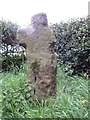
A photo on the NMR and an 1847 sepia picture on the Past Track website clearly identify this as the same monument.
A visit in person clearly lends credence that this could well have been a standing stone. It is a very crudely carved cross, sitting in an enclosure on the west side of the road from Biddulph Grange Garden (a National Trust property) in the direction of the Bridestones.
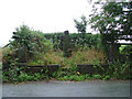
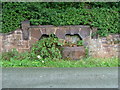
Opposite are two (dry) troughs, with a large raised enclosure behind them (now covered by undergrowth). Was there a well here, too?
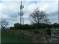
In the field to the east also stands a stone, but its nature is uncertain. Appears to be adjacent a hollow way, so perhaps serving as a waymarker for drove / livestock routes (in keeping with this monument's name), as well as nearby names such as "Fold Lane".
Parking is difficult - this is situated on a bend at the brough of a hill, so probably best to find somewhere else to park, and then carefully walk to visit this feature.
Note: This discovery of a likely Christianised standing stone comes during preparation for the Prehistoric Staffordshire talks in September.
You may be viewing yesterday's version of this page. To see the most up to date information please register for a free account.
")
")
")
")
Do not use the above information on other web sites or publications without permission of the contributor.
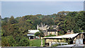
Nearby Images from Geograph Britain and Ireland:
©2019(licence)
©2006(licence)
©2006(licence)
©2011(licence)
©2010(licence)
The above images may not be of the site on this page, they are loaded from Geograph.
Please Submit an Image of this site or go out and take one for us!
Click here to see more info for this site
Nearby sites
Key: Red: member's photo, Blue: 3rd party photo, Yellow: other image, Green: no photo - please go there and take one, Grey: site destroyed
Download sites to:
KML (Google Earth)
GPX (GPS waypoints)
CSV (Garmin/Navman)
CSV (Excel)
To unlock full downloads you need to sign up as a Contributory Member. Otherwise downloads are limited to 50 sites.
Turn off the page maps and other distractions
Nearby sites listing. In the following links * = Image available
2.0km NNE 29° The Bridestones (Cheshire)* Chambered Tomb (SJ9058962190)
3.1km NNE 18° Bosley Cloud (2)* Standing Stone (Menhir) (SJ906634)
3.3km NNE 15° Bosley Cloud (1)* Standing Stone (Menhir) (SJ905636)
3.9km SSW 203° Red Cross* Ancient Cross (SJ881568)
4.1km ENE 66° Satan's Stone* Natural Stone / Erratic / Other Natural Feature (SJ93406206)
4.5km WNW 304° Congleton Museum* Museum (SJ859629)
4.8km ENE 68° St Helen's Well (Rushton Spencer)* Holy Well or Sacred Spring (SJ94076222)
4.9km S 178° Gawton's Well* Holy Well or Sacred Spring (SJ89825555)
5.0km S 178° Gawton's Stone* Modern Stone Circle etc (SJ898554)
5.0km WNW 282° St Marys (Astbury)* Ancient Cross (SJ847615)
5.2km WNW 283° Astbury Churchyard* Round Barrow(s) (SJ845616)
6.4km ENE 67° Heaton Low* Round Barrow(s) (SJ955629)
6.6km WSW 257° Little Moreton Hall* Round Barrow(s) (SJ832589)
6.9km NE 38° Bosley Minn 1* Standing Stone (Menhir) (SJ93886585)
7.1km NE 38° Bosley Minn 2 & 3* Standing Stones (SJ940660)
7.2km WNW 294° Loachbrook Farm* Long Barrow (SJ830634)
7.2km NE 37° Bosley Minn 4 & 5* Standing Stones (SJ940662)
7.3km E 84° Gun Hill Standing Stone* Standing Stone (Menhir) (SJ969612)
8.5km NE 52° Bartomley Farm* Long Barrow (SJ964656)
8.8km WSW 238° All Saints (Church Lawton)* Artificial Mound (SJ82165573)
8.9km E 101° Nine Pins* Stone Circle (SJ984587)
8.9km NE 38° Clulow Cross* Round Barrow(s) (SJ952674)
9.1km NE 40° Longgutter* Round Barrow(s) (SJ955674)
9.1km ESE 116° Cock Low (Leek)* Round Barrow(s) (SJ9783656426)
9.3km SSW 200° Tunstall Park* Natural Stone / Erratic / Other Natural Feature (SJ865517)
View more nearby sites and additional images


 We would like to know more about this location. Please feel free to add a brief description and any relevant information in your own language.
 Wir möchten mehr über diese Stätte erfahren. Bitte zögern Sie nicht, eine kurze Beschreibung und relevante Informationen in Deutsch hinzuzufügen.
 Nous aimerions en savoir encore un peu sur les lieux. S'il vous plaît n'hesitez pas à ajouter une courte description et tous les renseignements pertinents dans votre propre langue.
 Quisieramos informarnos un poco más de las lugares. No dude en añadir una breve descripción y otros datos relevantes en su propio idioma.