<< Our Photo Pages >> St Mary the Virgin (East Knoyle) - Ancient Cross in England in Wiltshire
Submitted by Sunny100 on Friday, 20 May 2011 Page Views: 4910
Early Medieval (Dark Age)Site Name: St Mary the Virgin (East Knoyle) Alternative Name: The East Knoyle CrossCountry: England County: Wiltshire Type: Ancient Cross
Nearest Town: Shaftesbury Nearest Village: East Knoyle
Map Ref: ST880305
Latitude: 51.073699N Longitude: 2.172658W
Condition:
| 5 | Perfect |
| 4 | Almost Perfect |
| 3 | Reasonable but with some damage |
| 2 | Ruined but still recognisable as an ancient site |
| 1 | Pretty much destroyed, possibly visible as crop marks |
| 0 | No data. |
| -1 | Completely destroyed |
| 5 | Superb |
| 4 | Good |
| 3 | Ordinary |
| 2 | Not Good |
| 1 | Awful |
| 0 | No data. |
| 5 | Can be driven to, probably with disabled access |
| 4 | Short walk on a footpath |
| 3 | Requiring a bit more of a walk |
| 2 | A long walk |
| 1 | In the middle of nowhere, a nightmare to find |
| 0 | No data. |
| 5 | co-ordinates taken by GPS or official recorded co-ordinates |
| 4 | co-ordinates scaled from a detailed map |
| 3 | co-ordinates scaled from a bad map |
| 2 | co-ordinates of the nearest village |
| 1 | co-ordinates of the nearest town |
| 0 | no data |
Internal Links:
External Links:
I have visited· I would like to visit
Jansold visited on 25th Feb 2016 - their rating: Cond: 2 Amb: 3 Access: 4
 (PID:145537)")
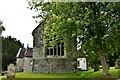
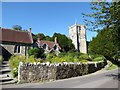
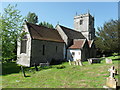
The church of St Mary the Virgin stands at the western side of the village and is located on Hindon Road (the Holloway road) 6 miles north of Shaftesbury. In the graveyard stands a weather-worn Anglo-Saxon cross.
At the west end of the churchyard stands an Anglo-Saxon cross dating from the 9th-11th century. It stands about 4 feet high but is now heavily worn. The cross-head is damaged and hardly recognisable. There are faint traces of carving on the shaft, but you need to get up close up to see it
You may be viewing yesterday's version of this page. To see the most up to date information please register for a free account.
Do not use the above information on other web sites or publications without permission of the contributor.
Nearby Images from Geograph Britain and Ireland:
©2022(licence)
©2016(licence)
©2010(licence)
©2016(licence)
©2016(licence)
The above images may not be of the site on this page, they are loaded from Geograph.
Please Submit an Image of this site or go out and take one for us!
Click here to see more info for this site
Nearby sites
Key: Red: member's photo, Blue: 3rd party photo, Yellow: other image, Green: no photo - please go there and take one, Grey: site destroyed
Download sites to:
KML (Google Earth)
GPX (GPS waypoints)
CSV (Garmin/Navman)
CSV (Excel)
To unlock full downloads you need to sign up as a Contributory Member. Otherwise downloads are limited to 50 sites.
Turn off the page maps and other distractions
Nearby sites listing. In the following links * = Image available
2.8km WNW 300° Puckwell* Holy Well or Sacred Spring (ST856319)
5.5km S 170° Castle Rings* Hillfort (ST889251)
6.9km N 353° Pertwood Down Long Barrow Long Barrow (ST872374)
7.1km E 95° Tisbury Circle* Stone Circle (ST951299)
7.6km NE 42° Grim's Ditch 3 (Wiltshire) Misc. Earthwork (ST931361)
7.6km NW 312° Rodmead Barrow Cemetery Barrow Cemetery (ST823356)
8.0km NW 313° Rodmead Hill Enclosure Ancient Village or Settlement (ST82123593)
8.3km WSW 242° Gillingham Vicarage (Dorset) Ancient Cross (ST80682656)
8.6km ESE 105° Castle Ditches (Wiltshire)* Hillfort (ST963283)
8.6km WNW 298° Whitesheet Castle* Hillfort (ST804346)
8.9km SSE 164° Chapel Well (Donhead St Mary) Holy Well or Sacred Spring (ST90372196)
8.9km SE 135° White Sheet Hill Long Barrow (ST94242419)
9.1km WNW 301° Whitesheet Hill* Ancient Village or Settlement (ST80163518)
9.9km SE 130° Gallows Hill, Wiltshire Round Barrow(s) (ST95542411)
10.4km W 274° Bourton Monolith* Standing Stone (Menhir) (ST7757731221)
10.6km W 274° Egbert's Stone Standing Stone (Menhir) (ST774312)
10.8km ENE 77° Spring Head Holy Well or Sacred Spring (ST9855732867)
11.0km ESE 109° Buxbury Hill* Round Barrow(s) (ST984269)
11.0km E 80° Teffont Magna - St. Edwards Church* Ancient Cross (ST98923237)
11.1km ESE 112° Sutton Down long barrow* Long Barrow (ST983264)
11.1km NNE 27° Corton Long Barrow Long Barrow (ST9307740336)
11.3km SE 140° Winklebury Camp (Wiltshire) Hillfort (ST952218)
11.5km N 3° Sutton Common Henge* Henge (ST88544194)
11.5km NNE 33° Golden Barrow Round Barrow(s) (ST944401)
11.6km NW 317° Town Well (Maiden Bradley) Holy Well or Sacred Spring (ST8010039028)
View more nearby sites and additional images


 We would like to know more about this location. Please feel free to add a brief description and any relevant information in your own language.
 Wir möchten mehr über diese Stätte erfahren. Bitte zögern Sie nicht, eine kurze Beschreibung und relevante Informationen in Deutsch hinzuzufügen.
 Nous aimerions en savoir encore un peu sur les lieux. S'il vous plaît n'hesitez pas à ajouter une courte description et tous les renseignements pertinents dans votre propre langue.
 Quisieramos informarnos un poco más de las lugares. No dude en añadir una breve descripción y otros datos relevantes en su propio idioma.