<< Our Photo Pages >> Harbottle - Modern Stone Circle etc in England in Northumberland
Submitted by Anne T on Saturday, 03 June 2017 Page Views: 2997
Modern SitesSite Name: HarbottleCountry: England
NOTE: This site is 0.429 km away from the location you searched for.
County: Northumberland Type: Modern Stone Circle etc
Nearest Town: Bellingham Nearest Village: Harbottle
Map Ref: NT9296304793
Latitude: 55.337130N Longitude: 2.112484W
Condition:
| 5 | Perfect |
| 4 | Almost Perfect |
| 3 | Reasonable but with some damage |
| 2 | Ruined but still recognisable as an ancient site |
| 1 | Pretty much destroyed, possibly visible as crop marks |
| 0 | No data. |
| -1 | Completely destroyed |
| 5 | Superb |
| 4 | Good |
| 3 | Ordinary |
| 2 | Not Good |
| 1 | Awful |
| 0 | No data. |
| 5 | Can be driven to, probably with disabled access |
| 4 | Short walk on a footpath |
| 3 | Requiring a bit more of a walk |
| 2 | A long walk |
| 1 | In the middle of nowhere, a nightmare to find |
| 0 | No data. |
| 5 | co-ordinates taken by GPS or official recorded co-ordinates |
| 4 | co-ordinates scaled from a detailed map |
| 3 | co-ordinates scaled from a bad map |
| 2 | co-ordinates of the nearest village |
| 1 | co-ordinates of the nearest town |
| 0 | no data |
Internal Links:
External Links:
I have visited· I would like to visit
Anne T visited on 28th May 2017 - their rating: Cond: 3 Amb: 5 Access: 4 Harbottle Modern Standing Stone/Castle: From Holystone, we passed through Harbottle to get back to the A68, so stopped to look at the castle. The site is lovely.
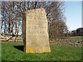
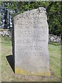
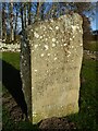
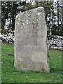
I spotted the modern standing stone to the west of the car park. The standing stone is inscribed with words:
The Sad Castle
Who Made me/Into a ruin/like an old city?
Was it the soldiers who rode out on horseback?
Was it my old enemy the Scots?
Or was it those Border Reivers?
Perhaps it was just the centuries passing.
Felicity Lance
Apparently there are supposed to be 2 poems, the above by Felicity Lance, another by Robert Corley from Harbottle School, carved into the stone by local stonemason David Edwick. I walked all around the stone, even photographing the other faces to see if anything came up on the camera, but only saw the one poem.
The Pastscape record says there could have been a pre-Conquest fortress on the site. The motte is very steep, and a walk around the moat/outer ditch was charming. Walking into the ruins from the eastern side, there are lots of lumps and bumps of the remains of walls and buildings. Very enigmatic. Really pleased to have been here.
")
Pastscape Monument No. 1855 gives much more detail about the history of Harbottle, which is largely regarded as 12th century, says "there as possibly a pre-Conquest fortress on the site" but gives no further information.
This modern standing stone is located on a grassy bank at the west of the small carpark for the castle. It is inscribed on its southern face with a poem by local schoolgirl Felicity Lane, called The Sad Castle, the words of which read:
Who Made me/Into a ruin/like an old city?
Was it the soldiers who rode out on horseback?
Was it my old enemy the Scots?
Or was it those Border Reivers?
Perhaps it was just the centuries passing.
Felicity Lance
It was carved into the stone by local stonemason David Edwick. There is apparently a second poem, but I didn't spot this. The castle is free to visit.
You may be viewing yesterday's version of this page. To see the most up to date information please register for a free account.
")
")
Do not use the above information on other web sites or publications without permission of the contributor.
Nearby Images from Geograph Britain and Ireland:

©2009(licence)
©2010(licence)
©2011(licence)
©2022(licence)
©2018(licence)
The above images may not be of the site on this page, they are loaded from Geograph.
Please Submit an Image of this site or go out and take one for us!
Click here to see more info for this site
Nearby sites
Key: Red: member's photo, Blue: 3rd party photo, Yellow: other image, Green: no photo - please go there and take one, Grey: site destroyed
Download sites to:
KML (Google Earth)
GPX (GPS waypoints)
CSV (Garmin/Navman)
CSV (Excel)
To unlock full downloads you need to sign up as a Contributory Member. Otherwise downloads are limited to 50 sites.
Turn off the page maps and other distractions
Nearby sites listing. In the following links * = Image available
1.3km E 94° Harbottle Peels Rock Art Rock Art (NT943047)
2.3km NNE 15° Alwinton/Newton/Clennell Cottages 3 Rock Art (NT9356207002)
2.3km NNE 15° Alwinton/Newton/Clennell Cottages 2* Rock Art (NT9356507004)
2.5km NNW 338° Gallow Law* Hillfort (NT92040709)
2.5km NNE 14° Alwinton/Newton/Clennell Cottages 4 Rock Art (NT9358007200)
2.5km NNE 14° Alwinton/Newton/Clennell Cottages 1 Rock Art (NT9359007200)
2.5km NNE 15° Alwinton/Newton/Clennell Cottages 5 Rock Art (NT9359307205)
2.9km SE 142° Campville Fort* Hillfort (NT94770250)
3.0km SE 129° Lady's Well (Holystone)* Holy Well or Sacred Spring (NT95270291)
3.1km N 352° Clennell Hill* Hillfort (NT92560784)
3.3km SE 133° St Mungo's Well (Northumberland)* Holy Well or Sacred Spring (NT954025)
3.6km NE 43° Biddlestone Stone Circle Stone Circle (NT954074)
3.6km SE 140° Five Barrows (Northumberland)* Barrow Cemetery (NT953020)
4.0km NNE 32° Biddlestone 1 Rock Art (NT9511508208)
4.0km NNE 32° Biddlestone N01 Rock Art (NT9514008211)
4.4km NE 39° Biddlestone* Ancient Cross (NT9574208230)
5.4km SSE 149° Five Kings* Stone Row / Alignment (NT9574000102)
5.8km WSW 241° Crow Stone (Otterburn)* Natural Stone / Erratic / Other Natural Feature (NT8783901967)
6.4km SE 141° Harehaugh Camp* Hillfort (NY96959980)
6.8km SE 142° Soldier's Fold* Hillfort (NY9716299453)
7.5km SE 136° Witchy Neuk* Hillfort (NY9817399358)
7.9km NE 39° Castle Hill (Northumberland)* Hillfort (NT98001094)
8.1km NE 55° Scrainwood 2 Rock Art (NT9963209442)
8.1km NE 53° Scrainwood 8 & 9 Rock Art (NT9946009720)
8.3km NE 54° Scrainwood 5 Rock Art (NT9967309664)
View more nearby sites and additional images


 We would like to know more about this location. Please feel free to add a brief description and any relevant information in your own language.
 Wir möchten mehr über diese Stätte erfahren. Bitte zögern Sie nicht, eine kurze Beschreibung und relevante Informationen in Deutsch hinzuzufügen.
 Nous aimerions en savoir encore un peu sur les lieux. S'il vous plaît n'hesitez pas à ajouter une courte description et tous les renseignements pertinents dans votre propre langue.
 Quisieramos informarnos un poco más de las lugares. No dude en añadir una breve descripción y otros datos relevantes en su propio idioma.