

<< Our Photo Pages >> Derry Hill Well - Holy Well or Sacred Spring in England in Wiltshire
Submitted by kernunos on Sunday, 24 April 2005 Page Views: 7460
Springs and Holy WellsSite Name: Derry Hill WellCountry: England
NOTE: This site is 7.792 km away from the location you searched for.
County: Wiltshire Type: Holy Well or Sacred Spring
Nearest Town: Derry Hill Nearest Village: Calne
Map Ref: ST9519570922
Latitude: 51.437274N Longitude: 2.070517W
Condition:
| 5 | Perfect |
| 4 | Almost Perfect |
| 3 | Reasonable but with some damage |
| 2 | Ruined but still recognisable as an ancient site |
| 1 | Pretty much destroyed, possibly visible as crop marks |
| 0 | No data. |
| -1 | Completely destroyed |
| 5 | Superb |
| 4 | Good |
| 3 | Ordinary |
| 2 | Not Good |
| 1 | Awful |
| 0 | No data. |
| 5 | Can be driven to, probably with disabled access |
| 4 | Short walk on a footpath |
| 3 | Requiring a bit more of a walk |
| 2 | A long walk |
| 1 | In the middle of nowhere, a nightmare to find |
| 0 | No data. |
| 5 | co-ordinates taken by GPS or official recorded co-ordinates |
| 4 | co-ordinates scaled from a detailed map |
| 3 | co-ordinates scaled from a bad map |
| 2 | co-ordinates of the nearest village |
| 1 | co-ordinates of the nearest town |
| 0 | no data |
Internal Links:
External Links:
")
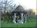
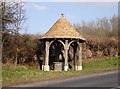
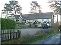
Now a rather quaint example of Victoriana, this drinking fountain is covered with a wood and slate conical roof. Written in gothic script around the roof lintel is a verse of rhyme (see below). Given it's location on the intersection of roads leading from (to?) Devizes, Chippenham and Calne this spring is likely to have been used for very many centuries.
The verse reads:
Here quench your thirst and make in me
An emblem of true charity,
Who why my Bounty bestow,
Am neither heard nor seen to flow.
Repaid by fresh supplies from Heaven,
For every cup of water give.
You may be viewing yesterday's version of this page. To see the most up to date information please register for a free account.
")
Do not use the above information on other web sites or publications without permission of the contributor.
Nearby Images from Geograph Britain and Ireland:
©2014(licence)
©2006(licence)
©2014(licence)
©2014(licence)
©2011(licence)
The above images may not be of the site on this page, they are loaded from Geograph.
Please Submit an Image of this site or go out and take one for us!
Click here to see more info for this site
Nearby sites
Key: Red: member's photo, Blue: 3rd party photo, Yellow: other image, Green: no photo - please go there and take one, Grey: site destroyed
Download sites to:
KML (Google Earth)
GPX (GPS waypoints)
CSV (Garmin/Navman)
CSV (Excel)
To unlock full downloads you need to sign up as a Contributory Member. Otherwise downloads are limited to 50 sites.
Turn off the page maps and other distractions
Nearby sites listing. In the following links * = Image available
3.3km SSW 206° Nun's Conduit* Holy Well or Sacred Spring (ST9376567982)
7.4km WNW 284° Holy Well (Biddestone)* Holy Well or Sacred Spring (ST8802772733)
7.6km SE 131° Heddington 1* Round Barrow(s) (SU00966600)
7.7km SE 130° King's Play Hill Long Barrow* Long Barrow (SU01066598)
7.9km SE 142° Oliver's Castle* Hillfort (SU00106468)
8.2km SE 145° Mother Anthony's Well* Holy Well or Sacred Spring (ST9994664221)
8.3km E 96° Cherhill cup marked stone* Rock Art (SU03476999)
8.4km WNW 297° Lanhill* Long Barrow (ST87737471)
8.5km E 88° Mount Wood Tumulus* Round Barrow(s) (SU03727119)
8.7km E 100° Oldbury Round Barrows Round Barrow(s) (SU03836939)
8.9km ESE 116° Morgans Hill Earthwork* Misc. Earthwork (SU0327067016)
9.3km SE 137° Devizes White Horse* Hill Figure or Geoglyph (SU01596414)
9.5km ESE 110° Bishops Cannings 6-10 Barrows* Round Barrow(s) (SU04136759)
9.6km E 100° Oldbury Hill Chambered Tomb (SU047693)
9.8km ESE 116° Old Shepherds Shore Barrow Group* Barrow Cemetery (SU0401466650)
9.8km E 99° Oldbury Castle* Hillfort (SU049693)
9.8km E 98° Cherhill White Horse* Hill Figure or Geoglyph (SU04986958)
9.9km E 97° Oldbury Earthwork Misc. Earthwork (SU05036964)
9.9km ESE 109° Bishops Cannings 11-14 Barrows* Round Barrow(s) (SU04606770)
9.9km ESE 119° Shepherd's Shore Chambered Tomb (SU039661)
10.0km E 101° Oldbury Barrow Round Barrow(s) (SU050690)
10.2km ESE 115° Baltic Farm Barrows* Round Barrow(s) (SU04486656)
10.3km ESE 114° Bishops Cannings 33 Bell Barrow* Round Barrow(s) (SU04596666)
10.4km ESE 110° North Down Bowl Barrow* Round Barrow(s) (SU04996740)
10.4km E 96° Whitehorse Plantation NE Barrow* Round Barrow(s) (SU0556669845)
View more nearby sites and additional images


 We would like to know more about this location. Please feel free to add a brief description and any relevant information in your own language.
 Wir möchten mehr über diese Stätte erfahren. Bitte zögern Sie nicht, eine kurze Beschreibung und relevante Informationen in Deutsch hinzuzufügen.
 Nous aimerions en savoir encore un peu sur les lieux. S'il vous plaît n'hesitez pas à ajouter une courte description et tous les renseignements pertinents dans votre propre langue.
 Quisieramos informarnos un poco más de las lugares. No dude en añadir una breve descripción y otros datos relevantes en su propio idioma.