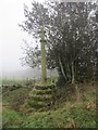
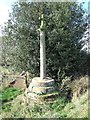
<< Our Photo Pages >> The Butter Cross (Cheddleton) - Ancient Cross in England in Staffordshire
Submitted by rogernorton on Wednesday, 29 October 2008 Page Views: 12718
Early Medieval (Dark Age)Site Name: The Butter Cross (Cheddleton)Country: England
NOTE: This site is 3.532 km away from the location you searched for.
County: Staffordshire Type: Ancient Cross
Nearest Town: Leek Nearest Village: Cheddleton
Map Ref: SJ989520
Latitude: 53.065241N Longitude: 2.017867W
Condition:
| 5 | Perfect |
| 4 | Almost Perfect |
| 3 | Reasonable but with some damage |
| 2 | Ruined but still recognisable as an ancient site |
| 1 | Pretty much destroyed, possibly visible as crop marks |
| 0 | No data. |
| -1 | Completely destroyed |
| 5 | Superb |
| 4 | Good |
| 3 | Ordinary |
| 2 | Not Good |
| 1 | Awful |
| 0 | No data. |
| 5 | Can be driven to, probably with disabled access |
| 4 | Short walk on a footpath |
| 3 | Requiring a bit more of a walk |
| 2 | A long walk |
| 1 | In the middle of nowhere, a nightmare to find |
| 0 | No data. |
| 5 | co-ordinates taken by GPS or official recorded co-ordinates |
| 4 | co-ordinates scaled from a detailed map |
| 3 | co-ordinates scaled from a bad map |
| 2 | co-ordinates of the nearest village |
| 1 | co-ordinates of the nearest town |
| 0 | no data |
Internal Links:
External Links:
I have visited· I would like to visit
KieKa would like to visit
ConnorBailey visited on 14th Jan 2024 - their rating: Cond: 4 Amb: 5 Access: 3
BrownEdger visited on 16th Feb 2014 - their rating: Cond: 4 Amb: 4 Access: 4 Never seen so many gnats in one place! Other than that a really good site and easy to access.
malboll have visited here
Average ratings for this site from all visit loggers: Condition: 4 Ambience: 4.5 Access: 3.5
 (PID:85114)")
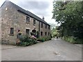
This cross is located at the junction of two public footpaths, one of which is the Staffordshire Moorlands Walk. It appears to be medieval and is in excellent condition but I have been unable to discover very much about it, other than I believe it is known as the Butter Cross and formed part of an estate belonging to a family called Challinor. Any further information would be much appreciated.
You may be viewing yesterday's version of this page. To see the most up to date information please register for a free account.
 (PID:268759)")
 (PID:85115)")
Do not use the above information on other web sites or publications without permission of the contributor.
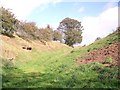
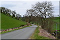
Nearby Images from Geograph Britain and Ireland:
©2011(licence)
©2020(licence)
©2011(licence)
©2014(licence)
©2023(licence)
The above images may not be of the site on this page, they are loaded from Geograph.
Please Submit an Image of this site or go out and take one for us!
Click here to see more info for this site
Nearby sites
Key: Red: member's photo, Blue: 3rd party photo, Yellow: other image, Green: no photo - please go there and take one, Grey: site destroyed
Download sites to:
KML (Google Earth)
GPX (GPS waypoints)
CSV (Garmin/Navman)
CSV (Excel)
To unlock full downloads you need to sign up as a Contributory Member. Otherwise downloads are limited to 50 sites.
Turn off the page maps and other distractions
Nearby sites listing. In the following links * = Image available
2.6km NE 39° Egg Well* Holy Well or Sacred Spring (SK00565403)
3.4km ESE 122° Ipstones tympanum* Early Christian Sculptured Stone (SK01785022)
3.9km N 357° Lady Well (Leek)* Holy Well or Sacred Spring (SJ9871455940)
4.5km NNW 346° Cock Low (Leek)* Round Barrow(s) (SJ9783656426)
4.6km N 355° Nicholson Museum and Art Gallery* Museum (SJ985566)
4.7km N 353° St Edward the Confessor* Ancient Cross (SJ9831956617)
5.2km ESE 115° Hopestone ; Ipstones/Foxt ; Staffordshire Natural Stone / Erratic / Other Natural Feature (SK0361049834)
6.2km E 81° The Morridge Stone Circle (SK0553)
6.7km N 356° Nine Pins* Stone Circle (SJ984587)
7.2km NNE 28° Thorncliffe Barrow Round Barrow(s) (SK023584)
7.2km ESE 113° Windywaycross* Early Christian Sculptured Stone (SK056492)
8.5km N 7° Leekfrith Stone* Standing Stone (Menhir) (SK000604)
8.5km N 9° Leekfrith Tumulus* Round Barrow(s) (SK003604)
8.8km ENE 69° Grindon Moor Barrow* Round Barrow(s) (SK071552)
8.8km ENE 68° Hurst Low* Round Barrow(s) (SK071553)
8.9km S 190° Cat Low* Round Barrow(s) (SJ97344320)
9.0km NE 44° Elkstone Barrow 2 Round Barrow(s) (SK052585)
9.0km NE 44° Elkstone Barrow 1* Round Barrow(s) (SK05155855)
9.1km E 87° Grub Low* Round Barrow(s) (SK08045255)
9.1km ESE 115° Hoften's Cross* Early Christian Sculptured Stone (SK072481)
9.4km NNW 348° Gun Hill Standing Stone* Standing Stone (Menhir) (SJ969612)
9.6km E 99° Stonesteads* Round Barrow(s) (SK08405052)
9.7km ESE 116° Cauldon Lowe Barrow Cemetery (SK076477)
9.7km E 88° Waterfall Low* Round Barrow(s) (SK08615231)
9.7km WNW 291° Gawton's Stone* Modern Stone Circle etc (SJ898554)
View more nearby sites and additional images


 We would like to know more about this location. Please feel free to add a brief description and any relevant information in your own language.
 Wir möchten mehr über diese Stätte erfahren. Bitte zögern Sie nicht, eine kurze Beschreibung und relevante Informationen in Deutsch hinzuzufügen.
 Nous aimerions en savoir encore un peu sur les lieux. S'il vous plaît n'hesitez pas à ajouter une courte description et tous les renseignements pertinents dans votre propre langue.
 Quisieramos informarnos un poco más de las lugares. No dude en añadir una breve descripción y otros datos relevantes en su propio idioma.