<< Our Photo Pages >> St Mary (Disley) - Ancient Cross in England in Cheshire
Submitted by TimPrevett on Thursday, 17 May 2007 Page Views: 5349
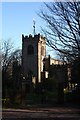
Early Medieval (Dark Age)Site Name: St Mary (Disley) Alternative Name: Disley Parish ChurchCountry: England County: Cheshire Type: Ancient Cross
Nearest Town: Disley
Map Ref: SJ97388444
Latitude: 53.356833N Longitude: 2.040827W
Condition:
| 5 | Perfect |
| 4 | Almost Perfect |
| 3 | Reasonable but with some damage |
| 2 | Ruined but still recognisable as an ancient site |
| 1 | Pretty much destroyed, possibly visible as crop marks |
| 0 | No data. |
| -1 | Completely destroyed |
| 5 | Superb |
| 4 | Good |
| 3 | Ordinary |
| 2 | Not Good |
| 1 | Awful |
| 0 | No data. |
| 5 | Can be driven to, probably with disabled access |
| 4 | Short walk on a footpath |
| 3 | Requiring a bit more of a walk |
| 2 | A long walk |
| 1 | In the middle of nowhere, a nightmare to find |
| 0 | No data. |
| 5 | co-ordinates taken by GPS or official recorded co-ordinates |
| 4 | co-ordinates scaled from a detailed map |
| 3 | co-ordinates scaled from a bad map |
| 2 | co-ordinates of the nearest village |
| 1 | co-ordinates of the nearest town |
| 0 | no data |
Internal Links:
External Links:
 (PID:30561)")
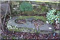
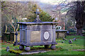
10th Century twin socket base for cross shafts in churchyard of St Mary, Disley. Other fragments at Lyme Park.
You may be viewing yesterday's version of this page. To see the most up to date information please register for a free account.
Do not use the above information on other web sites or publications without permission of the contributor.
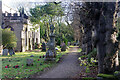
Nearby Images from Geograph Britain and Ireland:
©2012(licence)
©2012(licence)
©2024(licence)
©2024(licence)
©2012(licence)
The above images may not be of the site on this page, they are loaded from Geograph.
Please Submit an Image of this site or go out and take one for us!
Click here to see more info for this site
Nearby sites
Key: Red: member's photo, Blue: 3rd party photo, Yellow: other image, Green: no photo - please go there and take one, Grey: site destroyed
Download sites to:
KML (Google Earth)
GPX (GPS waypoints)
CSV (Garmin/Navman)
CSV (Excel)
To unlock full downloads you need to sign up as a Contributory Member. Otherwise downloads are limited to 50 sites.
Turn off the page maps and other distractions
Nearby sites listing. In the following links * = Image available
2.3km SSW 204° Lyme Park* Ancient Cross (SJ96458235)
2.9km SSW 198° Knightslow Wood W* Round Barrow(s) (SJ965817)
2.9km SSW 198° Knightslow Wood E Round Barrow(s) (SJ965817)
2.9km SSW 204° Knights Low NW Round Barrow(s) (SJ962818)
2.9km SSW 200° Knightslow Wood* Round Barrow(s) (SJ964817)
3.0km SSW 197° Knights Low W Round Barrow(s) (SJ965816)
3.0km SSW 199° Knights Low E* Round Barrow(s) (SJ964816)
3.1km NNE 25° Mellor Moor* Cairn (SJ9867187246)
3.1km S 180° Bowstones* Ancient Cross (SJ9739181309)
3.5km SE 142° The Dipping Stone* Ancient Cross (SJ99558171)
3.5km SSE 161° Stone near Higher Cornfield Farm* Standing Stone (Menhir) (SJ985811)
3.6km SE 133° Ringstone (Whaley Bridge) Stone Circle (SK000820)
3.8km SE 140° Hawkhurst Head* Standing Stone (Menhir) (SJ99838149)
4.2km S 185° Sponds Hill N* Round Barrow(s) (SJ970803)
4.3km S 185° Sponds Hill S Round Barrow(s) (SJ970802)
4.5km N 10° Mellor Hillfort* Hillfort (SJ982889)
4.6km S 175° Reed Hill* Round Barrow(s) (SJ978799)
5.3km S 182° Further Harrop* Round Barrow(s) (SJ972791)
5.3km SSW 196° Andrew's Knob Round Barrow(s) (SJ959793)
5.6km S 177° Charles Head* Round Barrow(s) (SJ977788)
6.1km NNE 32° Ringstones (Derbyshire)* Stone Circle (SK006896)
6.2km E 98° Chinley Churn Barrow Round Barrow(s) (SK035836)
6.4km SSW 213° Nab Wood Round Barrow(s) (SJ939791)
6.4km SE 138° The Shall Cross* Ancient Cross (SK0165579615)
6.5km SSE 161° Windgather Rocks Cup-Mark Stone Rock Art (SJ995783)
View more nearby sites and additional images


 We would like to know more about this location. Please feel free to add a brief description and any relevant information in your own language.
 Wir möchten mehr über diese Stätte erfahren. Bitte zögern Sie nicht, eine kurze Beschreibung und relevante Informationen in Deutsch hinzuzufügen.
 Nous aimerions en savoir encore un peu sur les lieux. S'il vous plaît n'hesitez pas à ajouter une courte description et tous les renseignements pertinents dans votre propre langue.
 Quisieramos informarnos un poco más de las lugares. No dude en añadir una breve descripción y otros datos relevantes en su propio idioma.