<< Our Photo Pages >> Mount Shasta - Natural Stone / Erratic / Other Natural Feature in United States in The West
Submitted by Andy B on Sunday, 17 January 2010 Page Views: 7056
Natural PlacesSite Name: Mount ShastaCountry: United States
NOTE: This site is 67.331 km away from the location you searched for.
Region: The West Type: Natural Stone / Erratic / Other Natural Feature
Latitude: 41.409197N Longitude: 122.194889W
Condition:
| 5 | Perfect |
| 4 | Almost Perfect |
| 3 | Reasonable but with some damage |
| 2 | Ruined but still recognisable as an ancient site |
| 1 | Pretty much destroyed, possibly visible as crop marks |
| 0 | No data. |
| -1 | Completely destroyed |
| 5 | Superb |
| 4 | Good |
| 3 | Ordinary |
| 2 | Not Good |
| 1 | Awful |
| 0 | No data. |
| 5 | Can be driven to, probably with disabled access |
| 4 | Short walk on a footpath |
| 3 | Requiring a bit more of a walk |
| 2 | A long walk |
| 1 | In the middle of nowhere, a nightmare to find |
| 0 | No data. |
| 5 | co-ordinates taken by GPS or official recorded co-ordinates |
| 4 | co-ordinates scaled from a detailed map |
| 3 | co-ordinates scaled from a bad map |
| 2 | co-ordinates of the nearest village |
| 1 | co-ordinates of the nearest town |
| 0 | no data |
Be the first person to rate this site - see the 'Contribute!' box in the right hand menu.
Internal Links:
External Links:
")
At the time of Euro-American contact in the 1820s, the Native American tribes who lived within view of Mount Shasta included the Shasta, Okwanuchu, Modoc, Achomawi, Atsugewi, Karuk, Klamath, Wintu, and Yana tribes.
The lore of some of the American Indians in the area held that Shasta is inhabited by the spirit chief Skell who descended from heaven to the mountain's summit.
A group of Native Americans from the McCloud River area practice rituals on the mountain. Other surrounding tribes also continue to use the mountain for spiritual practices.
Source: Wikipedia
You may be viewing yesterday's version of this page. To see the most up to date information please register for a free account.
")
")
")
")
Do not use the above information on other web sites or publications without permission of the contributor.
Nearby Images from Flickr
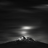
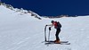
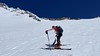
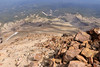
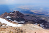
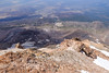
The above images may not be of the site on this page, but were taken nearby. They are loaded from Flickr so please click on them for image credits.
Click here to see more info for this site
Nearby sites
Click here to view sites on an interactive map of the areaKey: Red: member's photo, Blue: 3rd party photo, Yellow: other image, Green: no photo - please go there and take one, Grey: site destroyed
Download sites to:
KML (Google Earth)
GPX (GPS waypoints)
CSV (Garmin/Navman)
CSV (Excel)
To unlock full downloads you need to sign up as a Contributory Member. Otherwise downloads are limited to 50 sites.
Turn off the page maps and other distractions
Nearby sites listing. In the following links * = Image available
18.5km NNW 341° Pluto's Cave* Cave or Rock Shelter
177.9km WSW 249° Indian Island Shellmounds* Artificial Mound
202.5km NE 42° Paisley Caves* Cave or Rock Shelter
226.9km ENE 65° Lake County Rock art Rock Art
237.6km NNE 23° Fort Rock Cave Cave or Rock Shelter
245.5km ENE 57° Petroglyph Lake Rock Art
245.9km NNE 25° Cougar Mountain Cave Cave or Rock Shelter
272.7km SSW 210° Van Damme State Park Shellmounds* Artificial Mound
281.7km ESE 119° Winnemucca Lake Petroglyphs* Rock Art
291.3km ENE 68° Catlow Cave Cave or Rock Shelter
294.1km SSW 194° Cloverdale Stone Rock Art
307.8km SSE 164° Maidu Indian Interpretive Center* Ancient Village or Settlement
311.8km S 188° Knight's valley stone Rock Art
326.9km NNE 14° Redmond Lava Caves Cave or Rock Shelter
343.9km SSW 193° Duncans Landing Rockshelter* Cave or Rock Shelter
346.2km ESE 116° Lovelock Cave* Cave or Rock Shelter
351.4km SSW 192° Bodega Harbor Shellmound* Artificial Mound
353.1km SSW 192° Bodega Head Shellmound* Artificial Mound
368.1km SSE 151° Miwok Salt Basins Ancient Mine, Quarry or other Industry
374.8km SE 125° Grimes Point Arch. Area* Cave or Rock Shelter
385.3km NE 50° Stinkingwater Medicine Wheels* Stone Circle
389.8km S 184° Ring Mountain Carving
393.9km S 181° West Berkeley Shell Mound* Artificial Mound
394.6km SE 140° Pillars (Nevada)* Cairn
397.5km S 181° Emeryville Shellmound* Artificial Mound
View more nearby sites and additional images


 We would like to know more about this location. Please feel free to add a brief description and any relevant information in your own language.
 Wir möchten mehr über diese Stätte erfahren. Bitte zögern Sie nicht, eine kurze Beschreibung und relevante Informationen in Deutsch hinzuzufügen.
 Nous aimerions en savoir encore un peu sur les lieux. S'il vous plaît n'hesitez pas à ajouter une courte description et tous les renseignements pertinents dans votre propre langue.
 Quisieramos informarnos un poco más de las lugares. No dude en añadir una breve descripción y otros datos relevantes en su propio idioma.